- 1997–98 South-West Indian Ocean cyclone season
infobox hurricane season
Basin=SWI
Year=1998
Track=1997-1998 South-West Indian Ocean cyclone season summary.jpg
First storm formed=January 17 ,1997
Last storm dissipated=April 22 ,1998
Strongest storm name=Anacelle
Strongest storm pressure=950
Strongest storm winds=75
Average wind speed=10
Total depressions=
Total storms=6 official, 5 unofficial
Total hurricanes=1
Total intense=
Fatalities=
Da
Inflated=
five seasons=1995–96, 1996–97, 1997–98, 1998–99, 1999–00The 1997-98 South-West Indian Ocean cyclone season was an event in the annual cycle oftropical cyclone formation. It ran fromNovember 15 ,1997 toApril 30 ,1998 , except forMauritius and theSeychelles , where it ran untilMay 15 . These dates conventionally delimit the period of each year when most tropical cyclones form in the basin, which is west of 90°E and south of theEquator . Tropical cyclones in this basin are monitored by theRegional Specialised Meteorological Centre inRéunion .__TOC__
torms
Tropical Depression A1 (13S)
Infobox Hurricane Small
Basin=SWI.jpg)
Formed=January 17
Dissipated=January 23
10-min winds=32
1-min winds=35
Pressure=995The first advisory by theJoint Typhoon Warning Center was released onJanuary 18 , while the cyclone was inland overMozambique . [http://australiasevereweather.com/cyclones/1998/summ9801.htm#9813 Tropical Cyclone 13-S --- 18-23 January] ] Some ships reported gale-force winds from the center and was forecast to intensify. By 1200UTC January 18 , winds had decreased to 35 mph (55 km/h) and became a tropical low. The next day, the low moved southward and started to strengthen again to a 40 mph (60 km/h) minimal tropical storm. The low turned eastsouthward and scraped the Mozambique coastline and re-entered the channel. Even though the low was over open waters, the system did not strengthen and the JTWC discontinued warnings onJanuary 23 . Torrential rains poured in Mozambique and Malawi, which destroyed crops and flooded villages.Tropical Cyclone Anacelle
Infobox Hurricane Small
Basin=SWI
Track=Anacelle 1998 track.pngFebruary 6
Dissipated=February 13
10-min winds=75
1-min winds=115
Pressure=950Joint Typhoon Warning Center issued its first advisory on a cyclone convert|275|nmi|km northeast ofSt. Brandon Island . The storm intensified as it moved westward and turned south onFebruary 9 . AtFebruary 10 , passed very close to St. Brandon Island with maximum sustained winds of 105 mph (165 km/h). Cotinuing southward, Anacelle boosted itself up to 135 mph (205 km/h), its peak intensity, onFebruary 11 . Anacelle passed overMauritius and turned southwestward. Anacelle dropped below hurricane-force winds onFebruary 13 and became extatropical twenty-four hours later. No damage from Anacelle is available.Tropical Storm 21S
Infobox Hurricane Small
Basin=SWI.jpg)
Formed=February 1
Dissipated=February 10
1-min winds=35
Pressure=997A tropical disturbance drifted near the coast ofMozambique to the southern tip ofMadagascar in early February. [http://australiasevereweather.com/cyclones/1998/summ9802.htm Tropical Cyclone 21-S - 9-10 February] ] Early onFebruary 9 , scatterometer data indicated that a convert|40|mi/h|km/h|abbr=on area of winds within the center. The Joint Typhoon Warning Center issued its first warnings on that days as Tropical Cyclone 21S. The system was located convert|225|nmi|km south of Tulear. Tropical Cyclone 21S had formed in a high wind shear environment and was unable to strengthen further. The weak cyclone moved off to the south-southeast and weakened into a tropical depression the next day.Moderate Tropical Storm Beltane
Infobox Hurricane Small
Basin=SWI.jpg)
Track=Beltane 1998 track.pngFebruary 3
Dissipated=February 14
10-min winds=35
1-min winds=40
Pressure=992February 16 . Convection began to organize very quickly, turning the disturbance into a tropical cyclone named Beltrane. By 600UTC , Beltrane moved convert|150|nmi|km northwest ofTulear, Madagascar , with winds of convert|40|mi/h|km/h|abbr=on. Beltrane peaked at convert|45|mi/h|km/h|abbr=on winds onFebruary 16 at 1800UTC off the souhtern tip of Madagascar. By the morning ofFebruary 18 , all convection in Beltrane was sheared apart. The lastJoint Typhoon Warning Center advisory was released that evening, in the Mozambique Channel, convert|100|nmi|km from its point of origin. [http://australiasevereweather.com/cyclones/1998/summ9802.htm Tropical Cyclone Beltane (TC-23S) 17-18 February] ]Tropical Storm Victor-Cindy
Infobox Hurricane Small
Basin=SWI
Track=Victor-Cindy 1998 track.pngFebruary 16
Dissipated=February 18
1-min winds=35Tropical Depression D1 (24S)
Infobox Hurricane Small
Basin=SWI
Formed=February 16
Dissipated=February 18
10-min winds=30
1-min winds=45
Pressure=997The first advisory on Tropical Cyclone 24S was issued onFebruary 16 by theJoint Typhoon Warning Center , about convert|500|nmi|km east ofLa Reunion . [http://australiasevereweather.com/cyclones/1998/summ9802.htm Tropical Cyclone 24-S - 16-19 February] ] At that time, Tropical Cyclone 24S had winds of convert|40|mi/h|km/h|abbr=on. Tropical Cyclone 24S moved to the southeast onFebruary 17 , but moved eastward the next day. Wind shear and low temperatures made it impossible for 18th. The final warning on Tropical Cyclone 24S was released onFebruary 19 after being forecast to merge with cold front in the forecast period.Moderate Tropical Storm Donaline
Infobox Hurricane Small
Basin=SWI
Track=Donaline 1998 track.pngMarch 4
Dissipated=March 10
10-min winds=35
1-min winds=40
Pressure=988Joint Typhoon Warning Center onGuam issued their first bulletins on a developing depression in the west-central South Indian Ocean onMarch 6 . The depression became a storm onMarch 7 with winds of convert|45|mi/h|km/h|abbr=on. Donaline began by drifting generally to the east, but byMarch 8 , Donaline had started moving south. At this time, the storm had reached its peak intensity of 65 mph (100 km/h). Afterwards, Donaline began to weaken and accelerate to the south-southeast. Donaline's low-level circulation had becoming completely exposed to shear onMarch 9 and the final warning was released onMarch 10 , when it was downgraded to a depression. [http://www.australiasevereweather.com/cyclones/1998/summ9803.txt Donaline report] ]evere Tropical Storm Elsie
Infobox Hurricane Small
Basin=SWI
Track=Elsie 1998 track.pngMarch 8
Dissipated=March 18
10-min winds=55
1-min winds=90
Pressure=975Joint Typhoon Warning Center issued their first bulletin on a rapidly developing tropical system onMarch 12 . Elsie moved in a south-southwesterly direction for the next five days and reached its peak of 105 mph (165 km/h) onMarch 13 . The cyclone at this point was only convert|1000|nmi|km east ofRodrigues Island . Elsie had weakened as fast as it had intensified and byMarch 14 , the storm was encountering wind shear. The south-southwestern motion stopped onMarch 17 and the final warning was issue twelve hours later. The final warning indicated that Elsie was finish its extratropical transition within 24 hours.Tropical Depression Fiona
Infobox Hurricane Small
Basin=SWI
Track=Fiona 1998 track.pngMarch 15
Dissipated=March 20
10-min winds=30
1-min winds=35
Pressure=995Joint Typhoon Warning Center issued their first bulletin on Tropical Cyclone 28S onMarch 17 . [http://australiasevereweather.com/cyclones/1998/summ9803.htm#9828 Tropical Cyclone Fiona (TC-28S) --- 17-20 March] ] The initial warning indicated winds of 45 mph (70 km/h) and conditions were right for more strengthening. A passing shortwave inhibited future development and decreased the winds to convert|40|mi/h|km/h|abbr=on. During this time Fiona had drifted westward to an area about convert|215|nmi|km northeast ofMauritius . The weak Fiona moved to the southeast and curved back to the west later. After the trough lifted, Fiona gained some intensity but wind shear prohibited further development. The storm passed within convert|75|nmi|km east ofMauritius at around 1500UTC onMarch 19 . Continuing south, Fiona weakened and the final advisory was issued onMarch 20 . Winds of convert|44|mi/h|km/h|abbr=on were reported in the eastern section ofMauritius , but no rainfall or pressure measurements were recorded.Moderate Tropical Storm Gemma
Infobox Hurricane Small
Basin=SWI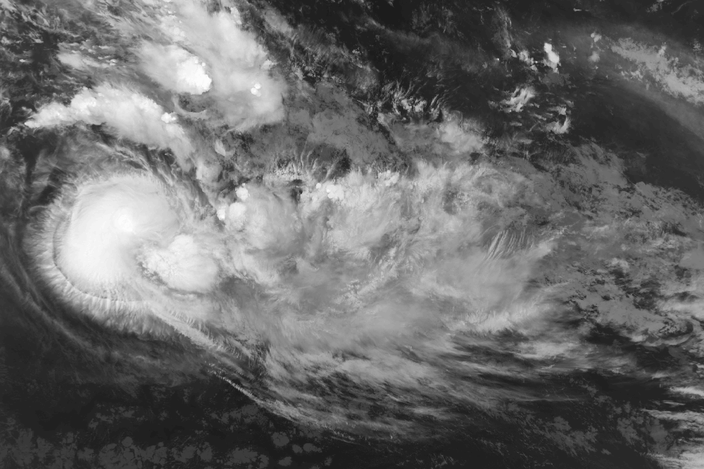
Track=Gemma 1998 track.pngApril 6
Dissipated=April 14
10-min winds=45
1-min winds=70
Pressure=985Joint Typhoon Warning Center issued their first bulletin about a developing tropical depression onApril 7 . The depression had maximum sustained winds of convert|35|mi/h|km/h|abbr=on. However, at the same time as Tropical Depression 32S foming, the JTWC issued a bulletin on the newly formed Tropical Depression 33S, which was located to the east-southeast. By 1200UTC onMarch 7 , the two systems had merged, resulting in a broad and weak wind field. Following the 32S-33S merger, the depression strengthened and was given the name Gemma onApril 9 . Gemma reached convert|65|mi/h|km/h|abbr=on winds and halted its westward motion, turning it into a south-southeasterly motion. OnApril 11 , Gemma reached its peak intensity of 80 mph (130 km/h). Afterwards, Gemma began to weaken due to wind shear separating the system.Microwave imagery on
April 12 indicated that low-level features were still intact, despite the wind shear. ByApril 13 , the weakening Gemma was down to convert|50|mi/h|km/h|abbr=on winds and the next day, Gemma was falling apart. TheJoint Typhoon Warning Center issued their final bulletin about Gemma onApril 15 , just convert|230|nmi|km east of its point of origin. [http://www.australiasevereweather.com/cyclones/1998/summ9804.txt Gemma report] ]Tropical Depression 33S
Infobox Hurricane Small
Basin=SWI
Formed=April 6
Dissipated=April 7
1-min winds=30
Pressure=1000TheJoint Typhoon Warning Center issued their first bulletin on the newly formed Tropical Depression 33S onApril 7 at 0000UTC . The depression was only convert|300|nmi|km southeast of Tropical Depression 32S (which later became Tropical Cyclone Gemma). Tropical Depression 33S moved northeastward while Tropical Depression 32S moved eastward. By 1200UTC April 7 , the center of TD-33S had pulled in closer to TD-32S. The depressions merged together the same day, ending the life of Tropical Depression 33S. Maximum sustained winds from Tropical Depression 33S were 35 mph. [http://www.australiasevereweather.com/cyclones/1998/summ9804.txt Tropical Depression 33S report] ]Tropical Storm 34S
Infobox Hurricane Small
Basin=SWI
Formed=April 17
Dissipated=April 22
1-min winds=40
Pressure=994The Joint Typhoon Warning Center began tracking the newly-formed Tropical Cyclone 34S onApril 19 nearDiego Garcia . [http://australiasevereweather.com/cyclones/1998/summ9804.htm#9834 Tropical Cyclone 34S --- 19-22 April] ] The cyclone was expected to reach hurricane-status, but it did not reach above gale intensity due to wind shear. Maximum sustained winds of convert|45|mi/h|km/h|abbr=on were recorded onApril 19 andApril 20 . A scatterometer pass on the next day found that the system was weakening and lessening in its circulation. The Joint Typhoon Warning Center quit tracking the storm onApril 22 , as the cyclone weakened into a depression.torm names
A tropical disturbance is named when it reaches moderate tropical storm strength. If a tropical disturbance reaches moderate tropical storm status west of 55°E, then the Sub-regional Tropical Cyclone Advisory Centre in
Madagascar assigns the appropriate name to the storm. If a tropical disturbance reaches moderate tropical storm status between 55°E and 90°E, then the Sub-regional Tropical Cyclone Advisory Centre inMauritius assigns the appropriate name to the storm. A new annual list is used every year so no names are retired.cite web|year=2003|title=Tropical Cyclone Operational Plan for the South Pacific and South-East Indian Ocean|accessdate=2008-08-15|publisher=World Meteorological Organization|url=http://ftp.wmo.int/pages/prog/www/TCP_vO/OperationPlans/TCP12-English2003.pdf]ee also
*
List of Southern Hemisphere cyclone seasons
*Atlantic hurricane seasons: 1997, 1998
*Pacific hurricane seasons: 1997, 1998
*Pacific typhoon seasons: 1997, 1998
*North Indian Ocean cyclone seasons: 1997, 1998References
External links
* [https://metocph.nmci.navy.mil/jtwc.html Joint Typhoon Warning Center (JTWC)]
* [http://www.meteo.fr/temps/domtom/La_Reunion/ Météo France (RSMC La Réunion)]
* [http://www.wmo.int/index-en.html World Meteorological Organization]
* [http://ftp.wmo.int/pages/prog/www/TCP_vO/Reports/RA1TCC14-Report.doc RA I Tropical Cyclone Committee Final Report]
* [http://metocph.nmci.navy.mil/jtwc/atcr/1998atcr/pdf.html Joint Typhoon Warning Center 1998 ATCR]
* [http://www.meteo.fr/temps/domtom/La_Reunion/base_cyclone/Saison/Saison_1998_1997.html 1997-98 Best Track Data from Météo France]
* [http://australiasevereweather.com/cyclones/tropical_cyclones_1998_summaries_and_track_data.htm September 1997 to June 1998 Tropical Cyclone Summaries and Operational Track Data]
Wikimedia Foundation. 2010.