- 1994 Atlantic hurricane season
Infobox hurricane season
first storm formed=June 30, 1994
last storm dissipated=November 21, 1994
strongest storm=Florence - 972mbar (28.70inHg ), 110mph (175km/h )
total storms=7
Total hurricanes=3
major storms=0
total daUSD ) $1.25 billion (2005 USD)
total fatalities=1,184
basin=Atlantic hurricane
five seasons=1992, 1993, 1994, 1995, 1996 The 1994 Atlantic hurricane season officially began on June 1, 1994, and lasted until November 30, 1994. These dates conventionally delimit the period of each year when mosttropical cyclone s form in theAtlantic basin . The season was very quiet, with only seven named storms, three hurricanes, and no major hurricanes; the low activity is the result of a strongEl Niño that lasted from 1991 to 1994. It was one of only 4 Atlantic hurricane seasons without major hurricanes; the others were 1968, 1972, and 1986, but records before 1944 remain incomplete.Tropical Storms Alberto and Beryl caused significant flood damage in the
Southeast United States . The worst storm of the season, however, was Hurricane Gordon, which killed 1,145 people, nearly all inHaiti .Storms
Tropical Storm Alberto
Infobox Hurricane Small
Basin=Atl.jpg)
Track=Alberto 1994 track.png
Dissipated=July 7
1-min winds=55
Pressure=993Yucatán Peninsula on July 2. Tropical Storm Alberto continued north, making landfall nearDestin, Florida on July 3 as a moderately strong tropical storm. The storm weakened quickly to a tropical depression, which then meandered over Georgia andAlabama until it dissipated on July 7.There were 30 deaths directly attributed to the effects of Tropical Storm Alberto, all from inland flooding. Some of the deaths were reported after the dissipation of the storm's circulation, as Alberto's remnants continued to produce heavy rain. Property damage was estimated at $500 million (1994
USD ), most in Georgia.Tropical Depression Two
Infobox Hurricane Small
Basin=Atl.jpg)
Track=Td21994rain.gif
Formed=July 20
Dissipated=July 21
1-min winds=30
Pressure=1015Tropical Depression #2 formed from a weather system of nontropical origin. A broad upper trough extended northeast from the Bahamas in mid-July. Thunderstorms increased within this trough to the north of the Bahamas on the 18th. A weak surface low gradually developed a couple hundred miles southeast of South Carolina by the 19th. That night, a tropical depression formed from this low. The depression hit it peak intensity of 1015 mbar and convert|35|mi/h|km/h|abbr=on on July 20th. The depression moved north making landfall inSouth Carolina and dissipated on July 23rd.Rainfall peaked at 6.84" in Hamlet, NC. [http://www.hpc.ncep.noaa.gov/tropical/rain/td2of1994.html]
* [http://www.nhc.noaa.gov/archive/storm_wallets/atlantic/atl1994/td2/prenhc Tropical Cyclone Report for Tropical Depression Two]Tropical Storm Beryl
Infobox Hurricane Small
Basin=Atl.jpg)
Track=Beryl 1994 track.png
Dissipated=August 19
1-min winds=50
Pressure=999Florida panhandle on August 15, just twelve hours before landfall nearPanama City, Florida . Beryl quickly strengthened before landfall and reached a peak intensity of convert|60|mi/h|km/h|abbr=on. Beryl caused inland flooding as it moved through Georgia, across theCarolinas , and all the way toConnecticut where it was absorbed by a frontal system.Tropical Storm Beryl was a weak system, and unlike Alberto, its rapid motion up the
Eastern Seaboard spread its heavy rainfall across a large area. Property damage was estimated at $73 million (1994USD ), most inSouth Carolina . Although there were no deaths caused by Beryl, a large number of people were injured by the 37 tornadoes Beryl produced as it weakened.Hurricane Chris
Infobox Hurricane Small
Basin=Atl.jpg)
Track=Chris 1994 track.png
Dissipated=August 23
1-min winds=70
Pressure=979Lesser Antilles andCape Verde on August 17, and reached hurricane strength the next day. It travelled generally northwest, then turned north and brushedBermuda as a minimal tropical storm on the 21st. Chris continued north, then turned northeast and merged with another system.Hurricane Chris caused no damage, and the only effect to Bermuda was 2.83 in (72 mm) of rain.
Tropical Depression Five
Infobox Hurricane Small
Basin=Atl.jpg)
Formed=August 29
Dissipated=August 31
1-min winds=30
Pressure=1005The wave that would become Tropical Depression Five was tracked beginning on August 17. The wave wouldn't get anymore convection until August 26. A reconnaissance airplane was released which found lower pressure and a well-defined mid-level circulation. The wave was upgraded into a depression on August 29 near the Yucatan Peninsula. The next day, Five hit its peak intensity of 1005 millibars. Five made landfall in Tampico on the 31st and dissipating the same day overMexico . Five dropped 2 to convert|4|in|mm of rain over Mexico but caused no damage.
* [http://www.nhc.noaa.gov/archive/storm_wallets/atlantic/atl1994/td5/prenhc/ Tropical Depression 5 Tropical Cyclone Report]Tropical Storm Debby
Infobox Hurricane Small
Basin=Atl.jpg)
Track=Debby 1994 track.png
Dissipated=September 11
1-min winds=60
Pressure=1006Puerto Rico the next day. Debby's remnants would continue to cause severe weather as they moved overHispaniola . Nine people were reported dead. Property damage estimates are not available, but flooding and landslides were severe in Saint Lucia.Tropical Storm Ernesto
Infobox Hurricane Small
Basin=Atl.jpg)
Track=Ernesto 1994 track.png
Dissipated=September 26
1-min winds=50
Pressure=1000Cape Verde and reached tropical storm strength on September 22. It moved north for two days, and by the 24th had weakened to a tropical depression. Ernesto dissipated on September 25 having never affected land.Tropical Depression Eight
Infobox Hurricane Small
Basin=Atl.jpg)
Formed=September 24
Dissipated=September 26
1-min winds=30
Pressure=1004The eighth depression of the season formed with little convection on September 19 in the southwesternCaribbean Sea . The area of convection lasted for several days moving from northwestern direction to the northeastern. The wave was estimated to have strengthened into Tropical Depression Eight on September 24 near the coast of Honduras. An Air Force aircraft found the depression with a poorly-organized circulation and a pressure of 1007 millibars.The depression moved west at six to nine knots on 25th. Just before landfall in
Mexico on the 25th, Eight hit its peak intensity of 35mph and 1004mbar . The depression made landfall in Mexico and dissipated the next day overGuatemala . Reports show that the remnants of Eight became Tropical Depression Ten.
* [http://www.nhc.noaa.gov/archive/storm_wallets/atlantic/atl1994/td8/prenhc Tropical Depression Eight Tropical Cyclone Report]Tropical Depression Nine
Infobox Hurricane Small
Basin=Atl.jpg)
Formed=September 27
Dissipated=September 29
1-min winds=30
Pressure=1007Tropical Depression Nine started out as a well-defined cloud circulation off of Africa on September 26. The circulation was upgraded to the ninth depression of the 1994 season, convert|150|nmi|km southeast from theCape Verde Islands the next day. The depression moved northward and lost its convention. The NHC declared Nine dissipated on September 29.Nine's peak intensity was 30 knots (35
mph ) and 1007 mbar.
* [http://www.nhc.noaa.gov/archive/storm_wallets/atlantic/atl1994/td9/prenhc/prelim01.gifTropical Depression Nine Tropical Cyclone Report]Tropical Depression Ten
Infobox Hurricane Small
Basin=Atl.jpg)
Formed=September 29
Dissipated=September 30
1-min winds=30
Pressure=1004An area of disturbed weather, related to Tropical Depression Eight, persisted for several days over the northwestCaribbean Sea and the Yucatan Peninsula. A tropical wave moved into the area, causing an increase in showers and cloudiness. Pressures began dropping and the NHC estimated that the wave became Tropical Depression Ten on September 29 about convert|150|nmi|km off the coast of Cuba. The system became better-organized and when the depression moved intoMexico , it was absorbed by a non-tropical system on 30th. Ten's peak intensity, acquired early on the 30th, was 1004 millibars with convert|30|kn|km/h|sing=on winds.The remnants of the depression dropped heavy rains in Florida, causing $5 million in damage (1994 USD). [http://www4.ncdc.noaa.gov/cgi-win/wwcgi.dll?wwevent~ShowEvent~200627]
* [http://www.nhc.noaa.gov/archive/storm_wallets/atlantic/atl1994/td10/prenhc Tropical Depression Ten Tropical Cyclone Report]ubtropical Storm One
Infobox Hurricane Small
Basin=Atl
Type=subtropical
Formed=October
Dissipated=OctoberIn addition to the seven named storms, the Hydrometeorological Prediction Center identified a subtropical storm in early October that moved acrossFlorida and the southeastern United States. The storm produced heavy rainfall along its path, peaking at over convert|10|in|mm in southernSouth Carolina . However, the storm was not confirmed by the National Hurricane Center. [http://www.hpc.ncep.noaa.gov/tropical/rain/suboct1994.html] The rainfall in South Carolina caused coastal flooding and flash flooding, with more than 147 houses, 6&nsbp;government buildings, 36 buildings, and at least 45&nsbp;cars were flooded. At least 37 roads were washed out or damaged, and more than 3,000 people were left without power after the rains. Damage from the storm exceeded $1 million (1994 USD). [http://www4.ncdc.noaa.gov/cgi-win/wwcgi.dll?wwevent~ShowEvent~237401]Hurricane Florence
Infobox Hurricane Small
Basin=Atl.jpg)
Track=Florence 1994 track.png
Dissipated=November 8
1-min winds=95
Pressure=979subtropical depression in the central Atlantic on November 2. As it moved generally northwest, it took on tropical characteristics and was classified as Tropical Storm Florence on the 4th. It reached hurricane strength, then turned sharply to the northeast and accelerated on November 6, as it was picked up by a strong trough. Florence was absorbed by a cold front on the 8th. There was no reported damage.Hurricane Gordon
Infobox Hurricane Small
Basin=Atl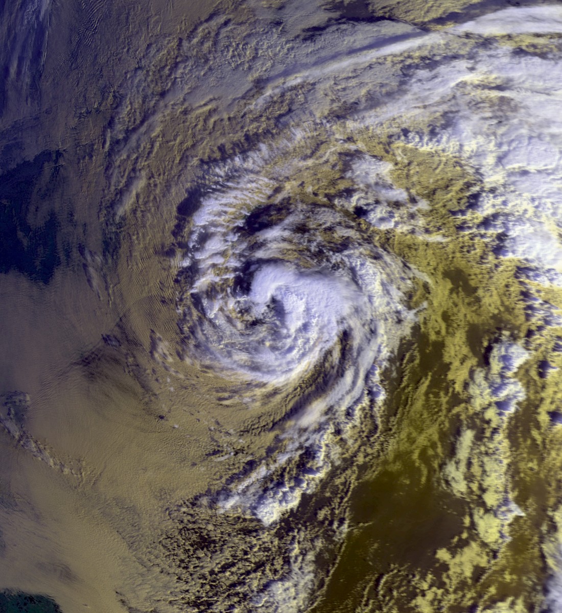
Track=Gordon 1994 track.png
Dissipated=November 21
1-min winds=75
Pressure=980Caribbean and intoFlorida . Although Gordon was only a tropical storm for most of its long existence, it caused enormous damage. AUnited Nations estimate of the death toll in Haiti was 1,122. There were six deaths reported inCosta Rica , five in theDominican Republic , two inJamaica , two inCuba , and eight inFlorida . Despite the death toll, theWorld Meteorological Organization did not retire the name, issuing an official statement crediting Jamaica and Cuba's warning infrastructure for the low loss of life there, and blaming Haiti's lack of such a system for the large number of deaths there.Property damage in the United States was estimated at $400 million (1994
US dollars ). Property damage statistics for other affected areas are not available, but were reportedly severe in both Haiti and Cuba.Nor'easter
Infobox Hurricane Small
Basin=Atl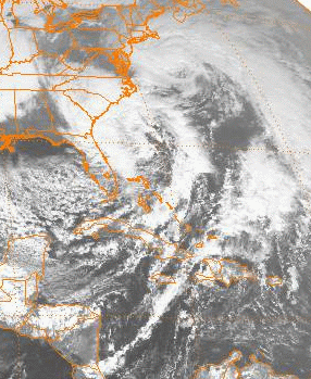
Formed=December 23
Dissipated=December 24
Pressure=1007
A powerful nor'easter with some subtropical characteristics struckNew England on December 23 and 24th. Although the storm was both intense and destructive, bringing hurricane force winds to the Southern New England shoreline, it was never officially classified as a tropical or subtropical system. This storm is sometimes referred to as the Great Christmas Eve Gale of 1994 by coastal Rhode Islanders. [http://www.nrcc.cornell.edu/climate/Impacts_12-94.html]Accumulated Cyclone Energy (ACE) Rating
The table on the right shows the ACE for each storm in the season. The ACE is, broadly speaking, a measure of the power of the hurricane multiplied by the length of time it existed for, so hurricanes that lasted a long time (such as Gordon), as well as particularly strong hurricanes, have higher ACEs.
Storm names
The following names were used for named storms that formed in the north Atlantic in 1994. No names were retired, so it was used again in the 2000 season. This is the same list used for the 1988 season except for Gordon and Joyce, which replaced Gilbert and Joan. A storm was named Gordon for the first time in 1994. Names that were not assigned are marked in tcname unused.
Retirement
The
World Meteorological Organization retired no names used in the 1994 season.ee also
*
List of Atlantic hurricanes
*List of Atlantic hurricane seasons
*1994 Pacific hurricane season
*1994 Pacific typhoon season
*1994 North Indian Ocean cyclone season
*Southern Hemisphere tropical cyclone seasons: 1993–94, 1994–95References
External links
* [http://www.aoml.noaa.gov/general/lib/lib1/nhclib/mwreviews/1994.pdf Monthly Weather Review]
* [ftp://ftp.nhc.noaa.gov/pub/storm_archives/atlantic/prelimat/atl1994 Detailed information on all storms from 1994]
* [http://www.wmo.ch/web/Press/warning.html WMO statement: "Early warning saves grief and money"]

Wikimedia Foundation. 2010.