- Cwmystwyth
-
Coordinates: 52°21′07″N 3°47′30″W / 52.35208°N 3.79177°W
Cwmystwyth Welsh: Cwmystwyth 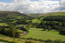
A view of Cwmystwyth looking across the only significant flat area of the cwm to be found before the river reaches maturity near Trawsgoed some 6 miles further west. Beyond, steep slopes rise to the Elenydd moors. Opposite is the cwm of the Nant Milwyn, at the head of which is the small but distinctive hill of Domen Milwyn.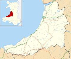
 Cwmystwyth
Cwmystwyth shown within CeredigionOS grid reference SN789740 - Cardiff 90 mi (140 km) SE Principal area Ceredigion Ceremonial county Dyfed Country Wales Sovereign state United Kingdom Post town ABERYSTWYTH Postcode district SY23 Dialling code 01974 Police Dyfed-Powys Fire Mid and West Wales Ambulance Welsh EU Parliament Wales UK Parliament Ceredigion Welsh Assembly Ceredigion List of places: UK • Wales • Ceredigion Cwmystwyth (also Cwm Ystwyth; English: "valley of the River Ystwyth") is a village located in Ceredigion, Wales near Devil's Bridge, and Pont-rhyd-y-groes.
The Ordnance Survey calculates Cwmystwyth to be the Centre point of Wales, (52°19′48.791″N 3°45′59.072″W / 52.33021972°N 3.76640889°W; grid reference SN7972871704) [1]
Contents
History
See Cwmystwyth Mines
Discovery of small, oval-shaped stone tools in the area points to the fact that it has been mined for lead since the time of ancient Britons and during Roman occupation. Documentation of mining activities occurred during the reign of Elizabeth I. She engaged the services of two German miners, then went on to sub-let to Mr. Hugh Myddleton.[2]
Community Archive Wales Project
Cofnodion Cwmystwyth is a recently established local history group based in Cwmystwyth. The group has 14 regular members of various ages drawn from the Communities First area of Tregaron Uplands, all with a passion for the history of the area. As well as including images, the archive includes transcriptions of census data, baptismal registers and log books as a means of interpreting the history of the village. In the long term, it is hoped that the project will act as a springboard for establishment of a Cwmystwyth History Society which would produce materials relating to the area and eventually to the creation of a heritage centre to showcase the history of the village. Cofnodion Cwmystwyth joined the Community Archives Wales project in 2007.
Climate
Cwmystwyth experiences an oceanic climate (Köppen climate classification Cfb) similar to almost all of Wales and the United Kingdom. This translates to a narrow range of temperatures, rainfall in all seasons and low sunshine levels, particularly at upland locations such as inland Wales.
The MetOffice maintains a weather station in the village, with online climate records dating back to 1959. Temperatures range from an absolute high of 32.3 °C (90.1 °F) recorded during July 2006,[3] down to an absolute low of −16.7 °C (1.9 °F), recorded during January 1963.[4] During an 'average' year, the warmest day will likely reach 26.1 °C (79.0 °F)[5] and the coldest night fall to −8 °C (17.6 °F).[6] In total just over 3 days[7] should record a temperature of 25.1 °C (77.2 °F) or above, and 59.3 nights[8] should report an air frost.
Rainfall, as one might expect for an elevated location in Wales, is high, at nearly 2000mm a year. At least 1mm will be observed on over 189 days[9] of the year, on average. All averages refer to the period 1971-2000.
Climate data for Cwmystwyth, elevation 301m, 1971-2000, extremes 1959- Month Jan Feb Mar Apr May Jun Jul Aug Sep Oct Nov Dec Year Record high °C (°F) 15.1
(59.2)16.5
(61.7)20.6
(69.1)23.8
(74.8)24.5
(76.1)29.6
(85.3)32.3
(90.1)30.4
(86.7)27.8
(82.0)23.8
(74.8)18.7
(65.7)13.3
(55.9)32.3
(90.1)Average high °C (°F) 5.8
(42.4)5.9
(42.6)7.9
(46.2)10.1
(50.2)13.7
(56.7)15.8
(60.4)18.0
(64.4)17.9
(64.2)15.4
(59.7)12.2
(54.0)8.6
(47.5)6.8
(44.2)11.51
(52.71)Average low °C (°F) 0.9
(33.6)0.6
(33.1)1.7
(35.1)2.6
(36.7)5.3
(41.5)8.0
(46.4)10.2
(50.4)10.1
(50.2)8.1
(46.6)5.9
(42.6)3.1
(37.6)1.7
(35.1)4.85
(40.73)Record low °C (°F) −16.7
(1.9)−13.3
(8.1)−13.9
(7.0)−6.6
(20.1)−3.5
(25.7)−2.2
(28.0)0.6
(33.1)0.5
(32.9)−3
(26.6)−3.9
(25.0)−7.8
(18.0)−11.1
(12.0)−16.7
(1.9)Precipitation mm (inches) 192.66
(7.585)139.31
(5.4846)158.19
(6.228)108.73
(4.2807)96.95
(3.8169)115.9
(4.563)115.69
(4.5547)134.64
(5.3008)150.98
(5.9441)187.66
(7.3882)205.77
(8.1012)213.49
(8.4051)1,819.97
(71.6524)Sunshine hours 31.9 53.4 74.3 126.4 165.5 138.9 153.6 142.6 109.7 81.5 44.4 25.4 1,147.6 Source no. 1: Royal Dutch Meteorological Institute[10] Source no. 2: MetOffice[11] References
- ^ "Saving the centre of Wales". BBC. 2002-10-24. http://news.bbc.co.uk/1/hi/wales/2271927.stm. Retrieved 2010-04-30.
- ^ Jenkinson, Henry Irwin (1878). Jenkinson's Practical Guide to North Wales. Oxford University.
- ^ "2006 Maximum". http://eca.knmi.nl/utils/monitordetail.php?seasonid=13&year=2006&indexid=TXx&stationid=1637. Retrieved 2011-09-24.
- ^ "1963 Minimum". http://eca.knmi.nl/utils/monitordetail.php?seasonid=7&year=1963&indexid=TNn&stationid=1637. Retrieved 2011-09-24.
- ^ "1971-2000 average warmest day". http://eca.knmi.nl/utils/calcdetail.php?seasonid=0&periodid=1971-2000&indexid=TXx&stationid=1637. Retrieved 2011-09-24.
- ^ "average coldest night". http://eca.knmi.nl/utils/calcdetail.php?seasonid=0&periodid=1971-2000&indexid=TNn&stationid=1637. Retrieved 2011-09-24.
- ^ "1971-2000 >25c days". http://eca.knmi.nl/utils/calcdetail.php?seasonid=0&periodid=1971-2000&indexid=SU&stationid=1637. Retrieved 2011-09-24.
- ^ "1971-2000 frosts". http://eca.knmi.nl/utils/calcdetail.php?seasonid=0&periodid=1971-2000&indexid=FD&stationid=1637. Retrieved 2011-09-24.
- ^ "1971-2000 wetdays". http://eca.knmi.nl/utils/calcdetail.php?seasonid=0&periodid=1971-2000&indexid=RR1&stationid=1637. Retrieved 2011-09-24.
- ^ "Climate Normals 1971–2000". KNMI. http://eca.knmi.nl/utils/calcdetail.php?seasonid=0&periodid=1971-2000&indexid=SS&stationid=1637. Retrieved 24 sep 2011.
- ^ "Long Term Data". Metoffice. http://www.metoffice.gov.uk/climate/uk/stationdata/cwmystwythdata.txt. Retrieved 24 sep 2011.
External links
 Media related to Cwmystwyth at Wikimedia Commons
- Jenkinson's Practical Guide to North Wales
- www.geograph.co.uk : Photos of Cwm Ystwyth and surrounding area
- Community Archives Wales
- Cwmystwyth Mining Community
Ceredigion Principal settlements 
Towns and villages Aberarth · Aberbanc · Aberffrwd · Aberlerry · Abermagwr · Aber-meurig · Aberporth · Alltyblacca · Betws Ifan · Beulah · Blaencelyn · Borth · Bow Street · Caemorgan · Caerwedros · Capel Bangor · Capel Dewi · Ciliau Aeron · Comins Coch · Cribyn · Cwmann · Cwmystwyth · Devil's Bridge · Dôl-y-bont · Eisteddfa Gurig · Eglwys Fach · Elerch · Ffostrasol · Furnace · Glandyfi · Gorsgoch · Gwbert · Llanarth · Llanbadarn Fawr · Llanddewi Brefi · Llandre (Llanfihangel Genau'r Glyn) · Llandyfriog · Llandygwydd · Llanfarian · Llanfihangel-y-Creuddyn · Llanfihangel Ystrad · Llangeitho · Llangoedmor · Llangrannog · Llangybi · Llangynfelyn · Llanilar · Llanon · Llanrhystud · Llansantffraed · Llanwenog · Llechryd · Lledrod · Lovesgrove · Melindwr · Mwnt · Oakford · Penbryn · Penparc · Penparcau · Penrhyn-coch · Penuwch · Peny-y-garn · Ponterwyd · Pontrhydfendigaid · Pontrhydygroes · Pont-Siân · Rhydowen · Rhydypennau · Salem · Silian · Talgarreg · Tal-y-bont · Tirymynach · Trefeurig · Tregaron · Tresaith · Tre-Taliesin · Tre'r Ddôl · Troed y Rhiw · Troedyraur · Upper Borth · Waunfawr · Y Faenor · Y Ferwig · Ynyslas · Ysbyty Ystwyth · Ystrad Aeron · Ystrad Meurig · Ystumtuen
Universities Rivers Castles Islands Categories:- Villages in Ceredigion
- Ceredigion geography stubs


Wikimedia Foundation. 2010.