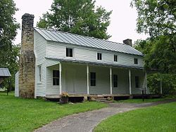
- Cunningham House and Outbuildings
-
Cunningham House and Outbuildings
 Cunningham House
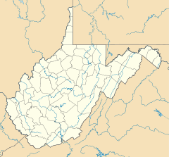

Location: Bulltown Historic Area at Burnsville Lake, near Napier, West Virginia Coordinates: 38°47′34″N 80°33′40″W / 38.79278°N 80.56111°WCoordinates: 38°47′34″N 80°33′40″W / 38.79278°N 80.56111°W Area: 0.7 acres (0.28 ha) Governing body: Army Corps of Engineers MPS: Bulltown MRA NRHP Reference#: 84003510
[1]Added to NRHP: March 21, 1984 Cunningham House and Outbuildings, also known as Cunningham Farm, is a historic home located near Napier, Braxton County, West Virginia. The house dates to the 1830s, and is a two story, log structure sided with white clapboards. Also located on the property is a food cellar and granary. The buildings are representative of traditional central West Virginia subsistence farming techniques.[2] The site was purchased by the Army Corps of Engineers during the development of Burnsville Lake, and is administered as part of the Bulltown Historic Area.
It was listed on the National Register of Historic Places in 1984.[1]
See also
- Union Civil War Fortification
References
- ^ a b "National Register Information System". National Register of Historic Places. National Park Service. 2009-03-13. http://nrhp.focus.nps.gov/natreg/docs/All_Data.html.
- ^ Robert F. Maslowski (October 1983). "National Register of Historic Places Inventory Nomination Form: Cunningham House and Outbuildings". State of West Virginia, West Virginia Division of Culture and History, Historic Preservation. http://www.wvculture.org/shpo/nr/pdf/braxton/84003510.pdf. Retrieved 2011-06-02.
U.S. National Register of Historic Places in West Virginia Lists by county Barbour • Berkeley • Boone • Braxton • Brooke • Cabell • Calhoun • Clay • Doddridge • Fayette • Gilmer • Grant • Greenbrier • Hampshire • Hancock • Hardy • Harrison • Jackson • Jefferson • Kanawha • Lewis • Lincoln • Logan • Marion • Marshall • Mason • McDowell • Mercer • Mineral • Mingo • Monongalia • Monroe • Morgan • Nicholas • Ohio • Pendleton • Pleasants • Pocahontas • Preston • Putnam • Raleigh • Randolph • Ritchie • Roane • Summers • Taylor • Tucker • Tyler • Upshur • Wayne • Webster • Wetzel • Wirt • Wood • Wyoming

Other lists Categories:- Historic house museums in West Virginia
- Farms on the National Register of Historic Places in West Virginia
- Houses on the National Register of Historic Places in West Virginia
- Houses completed in 1830
- Buildings and structures in Braxton County, West Virginia
- National Register of Historic Places listings in Braxton County, West Virginia
- Log house architecture in West Virginia
- Houses in Braxton County, West Virginia
- West Virginia Registered Historic Place stubs


Wikimedia Foundation. 2010.