- Crosspool
-
Coordinates: 53°22′47″N 1°31′10″W / 53.3796°N 1.5195°W
Crosspool 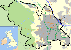
 Crosspool
Crosspool shown within SheffieldPopulation 7,070 [1] Metropolitan borough City of Sheffield Metropolitan county South Yorkshire Region Yorkshire and the Humber Country England Sovereign state United Kingdom Post town SHEFFIELD Postcode district S10 Dialling code 0114 Police South Yorkshire Fire South Yorkshire Ambulance Yorkshire EU Parliament Yorkshire and the Humber UK Parliament Sheffield Hallam List of places: UK • England • Yorkshire Crosspool is a suburb of the City of Sheffield, South Yorkshire, England, located 2.5 miles (4 km) west of the city centre. It is a Middle class residential area[2] in an elevated position above the Porter and Rivelin valleys and stands at around 200 metres above sea level. Crosspool is situated on the A57 road (Manchester Road) and is the last suburb on that highway before the City boundary and open countryside is reached.
Contents
History
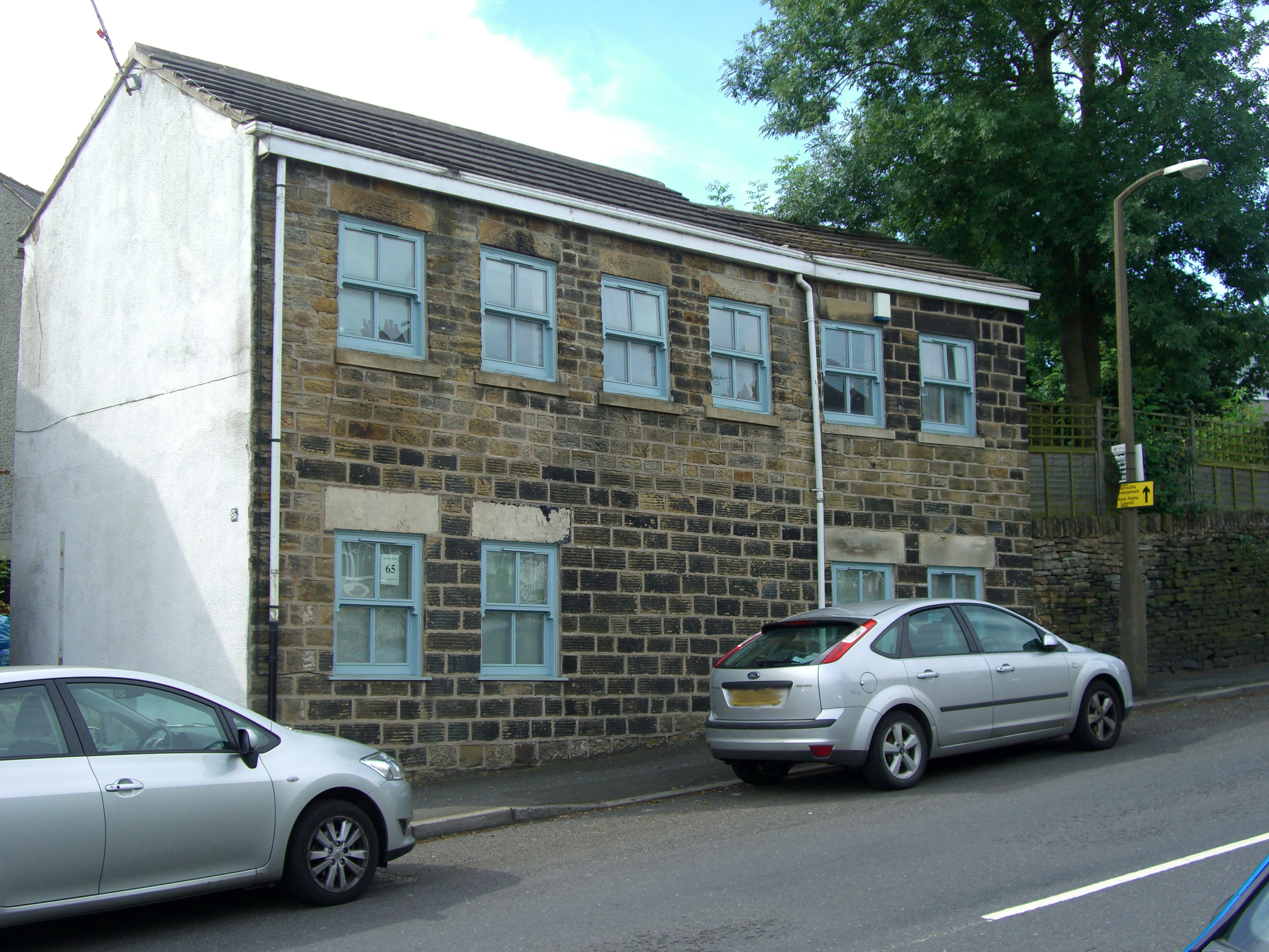
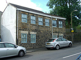 The oldest building in Crosspool. Situated at the junction of Sandygate Road and Ringstead Crescent, it was formerly a line of cottages and dates from the 1600s.
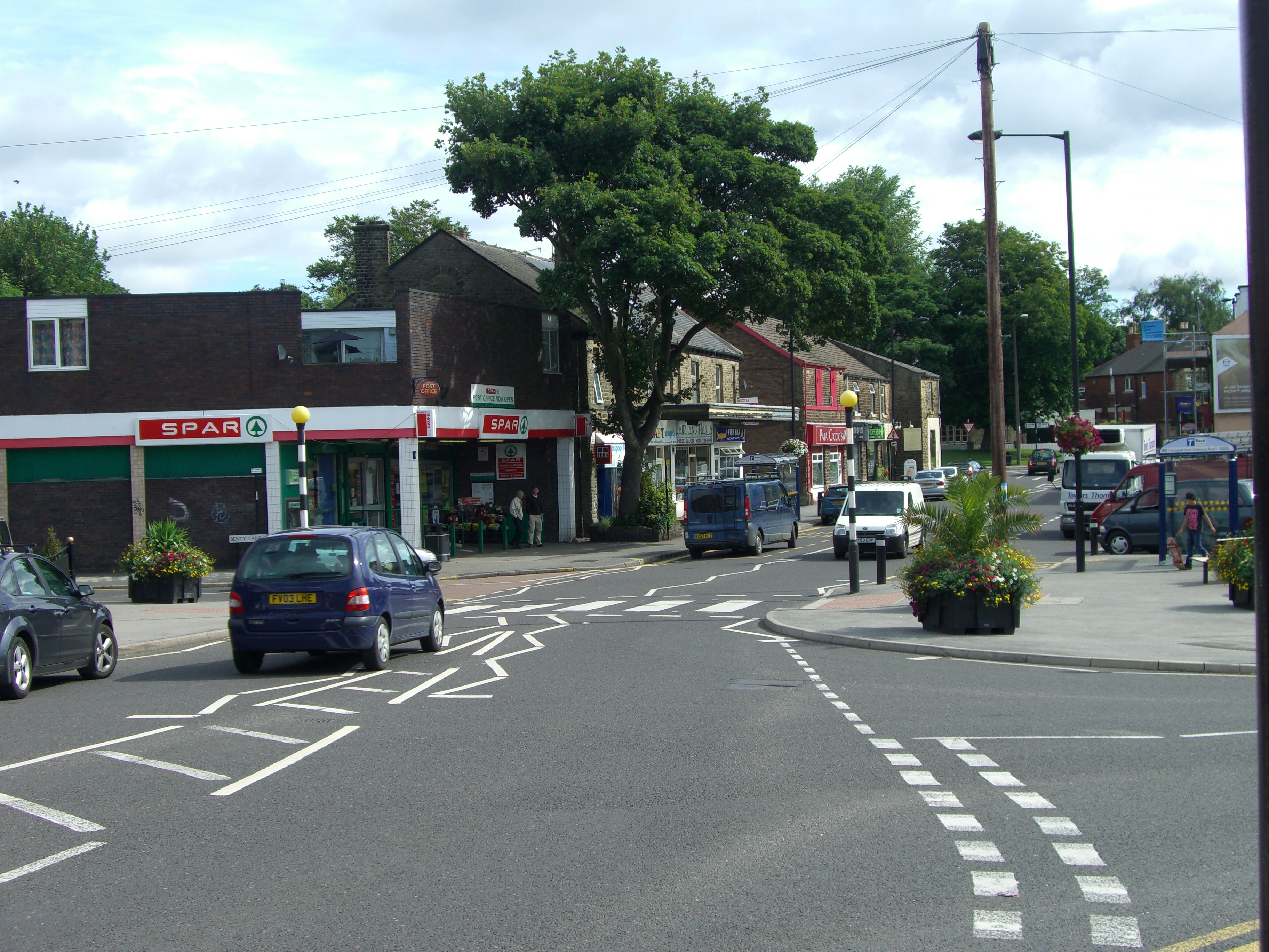
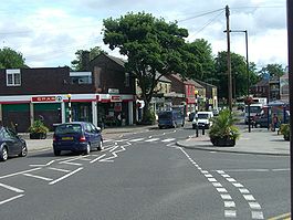 The shops at the junction of Sandygate Road and Manchester Road are regarded as the centre of Crosspool.
The area of Crosspool is a fairly recent creation, and unlike some Sheffield suburbs Crosspool does not have any ancient history as a village stretching back over the centuries. W. Fairbank’s “Map of the Parish of Sheffield in the County of York” published in 1795 shows it as a thinly populated unnamed area sprinkled with a few buildings. From the early centuries AD the Long Causeway ancient track passed through the area, this originated in Roman times as a highway connecting the forts at Templeborough and Buxton and continued in later centuries as a packhorse route.[3]
Throughout Medieval times the area was part of a deer hunting park known as Hallamshire Chase. This was an area of thousands of acres set aside for the Lords of Hallamshire after the Norman conquest of England.[3] Lydgate Hall was one the earliest substantial buildings in the area as it existed in the early 1700s although it was substantially altered and extended in the early 19th century. It was the home of the steel magnate Horation Bright (1827–1905) for the last 30 years of his life. The Hall was eventually demolished in the 1930s being replaced by housing on Lydgate Hall Crescent.
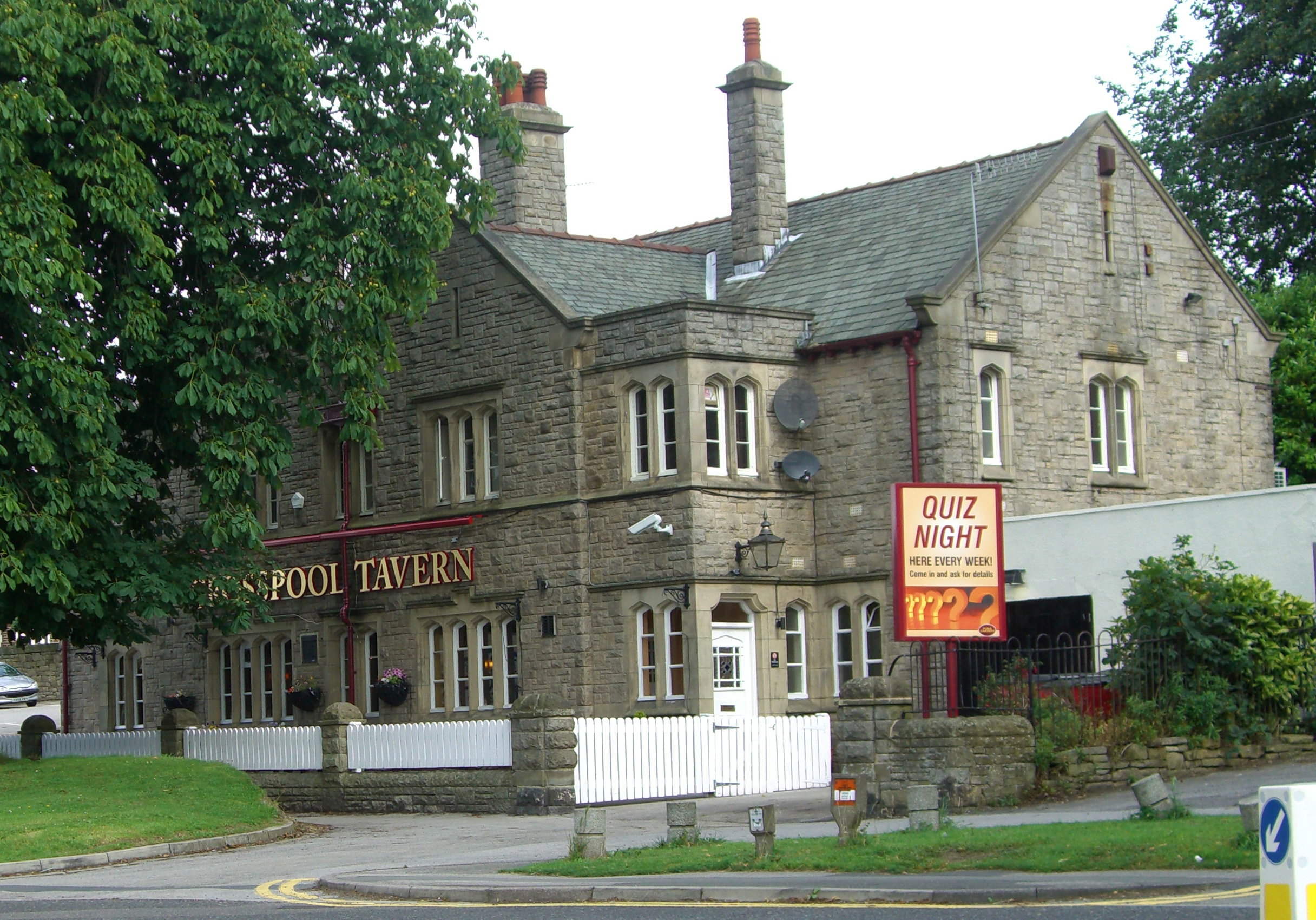
 The Crosspool Tavern, a pub on Manchester Road since 1824, the original building was replaced by this structure in 1930.
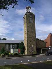 St. Columba church, Manchester Road dates from 1956.
Although there was never a Crosspool village, the area was strategically placed as two roads left Sheffield through the area and there was a toll gate as well as inns and a blacksmiths to serve the traveller. The main industry in the 18th and 19th century was farming although there was also extensive quarrying. The presence of several natural pools gave the area it’s name in the 1800s as travellers on the turnpike roads were said to have “crossed the pools” when they had passed through the neighbourhood and the name of Crosspool developed. The A57 road was built in 1820 and tolls were phased out in 1884 but housing development in the area was delayed because of Crosspool’s elevated position which developers thought would deter people from settling in the area.
Housing development eventually started in the 1880s but full scale building did not take place until after World War I. In 1913 Crosspool became the first area of Sheffield to receive a public transport service by bus as the Sheffield Tramway did not extend to the suburb. Crosspool suffered some bomb damage during World War II when bombs were dropped on Den Bank, Shore Lane, Sandygate Road and Ringstead Crescent.[4][5]
Demographics
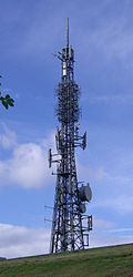 The Crosspool transmitter is a prominent landmark across Sheffield.
Crosspool is a suburb with vague boundaries and it merges with the adjacent neighbourhoods of Crookes, Fulwood and Ranmoor, and has sub-districts within it such as Tapton Hill, Sandygate and Hallam Head. It has a total population of 7,070 residents in a 2006/7 NHS Neighbourhood Profile, just 1.3% of the population of the City of Sheffield. Other statistics bear out Crosspool's status as a middle class area with almost 87% of residents being owner-occupiers of their houses compared to the Sheffield average of 60.2%. Almost 80% of Crosspool’s housing is either detached or semi-detached, again well above the average. 93.1% of Year 11 school pupils go on to further education compared to the Sheffield average of 86.8% while 38.5% of Crosspool’s adults have been educated to degree level in contrast to the Sheffield average of 18.8%.[6]
Buildings and landmarks
Present day Crosspool is centred on the area around the junction of Manchester Road, Sandygate Road and Lydgate Lane where there is a selection of shops, food take aways and a post office which since 2004 has been located inside a SPAR store. The Crosspool Tavern, a popular public house is also in this area. Other public houses in Crosspool are “The Sportsman” at Stephen Hill, “The Plough” at Sandygate and the "Hallamshire Hotel" on Lydgate Lane (currently closed, as of 2011). A new cafe opened on the Manchester Road in 2009. There are four schools in Crosspool for different age groups. Tapton School on Darwin Lane has over 1600 pupils between 11 and 18 years old and is a specialist college for science and the arts.[7] the Lower School of King Edward VII School is also located on Darwin Lane and was known as Crosspool Secondary Modern School until 1969. Lydgate Junior School is situated on Manchester Road and has around 480 pupils between the ages of 7 and 11.,[8] while Lydgate Infant School is on Lydgate Lane. Tapton Hall, a Grade II listed building is situated on Shore Lane, it was built in 1855 and has been the home of the industrialist Edward Vickers and the snuff mill owner George Wilson, today it is a conference and banqueting centre which is licensed to conduct weddings.[9]
The main churches in Crosspool are the Church of St. Colomba and Stephen Hill Methodist Church both of which are located on Manchester Road near the centre of the suburb. Because of the pressure from housing developers present day Crosspool has been left with very few open spaces for recreation with the small park/play area on the north side of Lydgate Lane being created on re-claimed land when an extensive quarry was filled in the first half of the 20th century. A prominent landmark, also on Lydgate Lane, is the Crosspool transmitter, officially known as the Tapton Hill transmitting station, which stands on the site of a covered reservoir and is well seen from many parts of Sheffield. The 57 metre high mast takes advantage of Crosspool’s elevated position to provide TV pictures and radio signals for Sheffield by the “line of sight” method.[10]
Sport
Hallam F.C., the second oldest football club in the world have their home ground in Crosspool at Sandygate Road, which is the oldest football ground in the world.[11] Crosspool hosts the start and finish of the Hallam Chase, a 3.25 miles (5.25 km) race starting at Hallam cricket ground and going on a very hilly route to Stannington church and then returning to the ground. The route has almost 250 metres of ascending and is run every year on Whit Tuesday. The race which is organised by the local athletics club the Hallamshire Harriers started in 1863.[12] Sebastian Coe the Olympic Games gold medal winning middle distance runner was brought up in Crosspool, attending Tapton School and being a member of Hallamshire Harriers.
Community
The community has a vibrant local community which co-ordinates itself through a community forum [13] which was established in 2003. Reports of open meeting minutes, together with items of local interest, letters, and adverts are published in the 'Crosspool Clarion' magazine, delivered to over 2500 local households, and also on the crosspool.info website. Many events and village activities are held in Crosspool. Every year since 2003 a summer fayre has been held in July, along with car boot sales in June and September.
The community tries to preserve and improve Crosspool’s access to the countryside, village atmosphere, and general character of the area.
References
- ^ Crosspool Neighbourhood Profile 2006/07, NHS
- ^ "Approach To Urban Sociology", Peter H. Mann, ISBN 0710034539 Page 91 Calls Crosspool a “Middle Class Residential Suburb”.
- ^ a b "Historic Hallamshire", David Hey, ISBN 1-84306-049-3 Gives details of Long Causeway and Hallamshire Chase.
- ^ "Cross pool (Images of England)", Judith Hanson, ISBN 0-7524-2821-7 Gives detailed history.
- ^ "Crookes Revisited", Crookes Local History Group, ISBN 0-9508064-1-2 Gives general history.
- ^ Crosspool Neighbourhood Profile 2006/7. Gives statistics.
- ^ Tapton School Website. Gives details of Tapton School.
- ^ Lydgate Junior School Profile. Gives details of Lydgate Junior School.
- ^ "Sheffield‘s Remarkable Houses", Roger Redfern, ISBN 0 9519148 3 9, page 20, Gives details of Tapton Hall.
- ^ www.aerialsandtv.com. Gives details of Crosspool transmitter.
- ^ www.theoldestfootballgroundintheworld.com. Gives details of Hallam F.C.
- ^ Hallamshire Harriers website. Gives details of Hallam Chase.
- ^ Crosspool Forum website. Details about the community, activities and events
Coordinates: 53°22′47″N 1°31′09″W / 53.3797°N 1.5193°W
Districts of Sheffield Abbeydale · Attercliffe · Batemoor · Beauchief · Beighton · Bradfield (High Bradfield · Low Bradfield) · Brightside · Burngreave · Carbrook · Chapeltown · Crookes · Crosspool · Darnall · Dore · Ecclesall · Ecclesfield · Fulwood · Gleadless · Greenhill · Grenoside · Halfway · Handsworth · Heeley · Hemsworth · Highfield · High Green · Hillsborough · Hyde Park · Longley · Lowfield · Loxley · Malin Bridge · Manor · Meersbrook · Middlewood · Millhouses · Mosborough · Neepsend · Nether Edge · Norton · Owlerton · Oughtibridge · Park Hill · Pitsmoor · Ranmoor · Ringinglow · Sharrow · Stocksbridge · Tinsley · Totley · Wadsley · Wadsley Bridge · Walkley · Wisewood · Woodseats · Woodhouse · Worrall
Categories:


Wikimedia Foundation. 2010.