- Malin Bridge
-
Coordinates: 53°24′01″N 1°30′39″W / 53.4003°N 1.5107°W
Malin Bridge
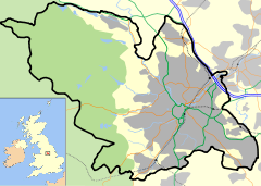
 Malin Bridge shown within Sheffield
OS grid reference SK325893 Metropolitan borough Sheffield Metropolitan county South Yorkshire Region Yorkshire and the Humber Country England Sovereign state United Kingdom Post town SHEFFIELD Postcode district S6 Dialling code 0114 Police South Yorkshire Fire South Yorkshire Ambulance Yorkshire EU Parliament Yorkshire and the Humber UK Parliament Sheffield Hillsborough List of places: UK • England • Yorkshire Malin Bridge is a suburb of the city of Sheffield, England. It is located at grid reference SK325893 and stands 2½ miles north-west of the city centre where the rivers Loxley and Rivelin meet. Malin Bridge is only a small district centred around the road bridge over the River Loxley which carries the B6076 road to Stannington, it is surrounded by the suburbs of Hillsborough, Wisewood, Walkley and Stannington.
Contents
History
The origin of the name Malin Bridge is obscure and several possible meanings have been put forward. The most probable is that the name derived from Malin Stacie, who was Lord of the Manor of Owlerton (which lies ¾ mile to the NE) between 1607 and 1652. It is possible that Stacie built the bridge or was responsible for its upkeep and it was therefore named after him. Another possibility is that the name derives from Milne Bridge, a common occurrence where a bridge is built near a mill. A third option is that it was named after “mellum” an old word that relates to stones in the bed of a river.
Origins
Malin Bridge came into existence because of the strategic importance of the bridge over the Loxley with a small population consisting of publican, wheelwright, blacksmith and saddler springing up in the immediate area to serve the travellers who used the bridge. In the first half of the 18th century grinding mills and water-powered forges started to be built in the area to harness the power of the rivers. The best known of these are the Malin Bridge Corn Mill which still stands today and the Mousehole Forge which dates from the 17th century and was a World famous anvil producer in its heyday.
The Great Sheffield Flood
In 1864 Malin Bridge was devastated by the Great Sheffield Flood with 102 people killed and 20 houses destroyed in the area . Whole families were wiped out with eleven people killed at the Stag Inn including eight members of the Armitage family as the inn was swept away. Seven members of the Bisby family were killed as the Cleakum Inn was inundated and swept away. The stone-built bridge was also carried off by the raging torrent and many of the industrial workshops were destroyed. Samuel Harrison wrote: “The populous village of Malin Bridge experienced the full fury of the flood, and suffered to an extent which is truly appalling…A bombardment with the newest and most powerful artillery could hardly have proved so destructive, and could not possibly have been nearly so fatal to human life.”[1][2]
Malin Bridge expanded with the building of Victorian terraced housing, it became a terminus for the Sheffield Tramway with a route from the city centre commencing on 19 May 1908. Buses could be then caught at Malin Bridge for travellers continuing to Bradfield and Stannington, at that time Malin Bridge was a busy shopping area and increasing traffic meant that the original narrow bridge over the Loxley to Stannington was replaced by a wider and stronger structure. The tram route from the city centre was taken over by buses in 1952.
Present day structures and developments
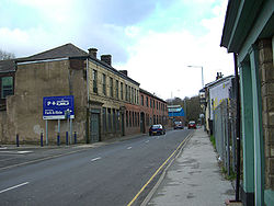
Present-day Malin Bridge is centred around a busy road junction which consists of a one-way traffic loop with various roads leading off. The A6101 (Rivelin Valley Road) leads off to the SW and after three miles connects to the A57 road which goes to Manchester. Other B class roads leave Malin Bridge for the suburbs of Stannington, Loxley and beyond. There are many small shops around the one-way system; the largest retail outlet in the area is Towsure, a sizeable outdoor equipment warehouse on Holme Lane. The Rivelin Valley fire station stands 200 yards along the Rivelin Valley Road.
Malin Bridge Corn Mill
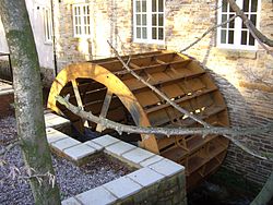
The grade two listed mill stands at the junction of Stannington Road and Holme Lane, the earliest written records for a mill on this site date from 1739, at that time it was used for grinding knives. It is one of the few remaining examples of an undershot water wheel in the country, it is six metres in diameter and 2.5 metres wide. The mill was completely destroyed in the flood of 1864 and was rebuilt by the Wilson family. Around 1915 it was converted to a corn mill by the Marsden family and operated until 1956. Since then it has been a Comet store, Chinese restaurant and a clothing store before becoming disused. In 2006 Sheffield City Council granted permission for 23 new apartments to be built on the site; the plans include strict controls to preserve the historic building and water wheel. The apartments and the restoration were completed in the second half of 2008.[3]
Mousehole Forge
The Mousehole Forge is situated on the River Rivelin just before it reaches Malin Bridge. It dates from the 1628, pre-dating the industrial revolution and is one of the few surviving water-powered forges in the country. It was famous for producing anvils that were exported all over the world, and it closed around 1933. The works also produced vices and various other engineering tools. Part of the site is a grade two listed building although much of the old machinery is open to the elements. It was a large concern; one of the buildings has now been converted to a private house although a lot of the site is ruined. From the 1930s to the 1950s a woodworking business, the Malin Bridge Construction Company, occupied one of the buildings. The importance of the site is emphasised by the fact that a book has been written about the forge by Richard A. Postman.[4][5][6]
Burgon & Ball
Burgon & Ball is an old Sheffield firm which originally made shears, scissors and knives. Its Sheffield origins date back to 1730; they moved to the La Plata Works on Holme Lane in Malin Bridge in 1873. The works were built on the site of a cutlery grinding wheel, which had existed since the 1690s, on land cleared after the 1864 flood. The works stand on the banks of the River Loxley and the river provided much of the power for the works throughout the 1900s. In the latter part of the 19th century the company patented a design for hand sheep shears and in one year sold over 300,000 pairs of shears. By 1920 the firm was producing more garden shears than sheep shears and it has continued to diversify into garden tools over the years. There is still a market for hand sheep shears and the company are now the only British manufacturer.[7]
St. Polycarp’s Church, Malin Bridge
Originally Malin Bridge was in the parish of Wadsley, however a separate parish was created in 1933 as the population of the area increased. A tin tabernacle had previously been used for worship as the area had no church and fundraising was commenced to build St. Polycarp’s at the junction of Loxley Road and Wisewood Lane. The foundation stone for the new church was laid by the Bishop of Sheffield and it was built by H.I. Potter of Fowler, Sandford & Potter in 1933-34, the former tin tabernacle remaining in use as the church hall until the 1960s when the new church hall was built adjacent to the church. The church is built of rustic brick with a pantile roof with no tower or spire; windows are grouped in threes. The interior consists of a four bay nave and a broad chancel with a tall arch. A small glazed porch was added in 1992 at the western end.[8][9]
Malin Bridge Supertram Terminus
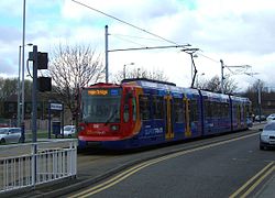
Malin Bridge was chosen as one of the termini of the Sheffield Supertram; it is the western limit of the blue line service which runs eastwards to the city centre and then onto Halfway. The terminus was first used on October 23, 1995 and is a single platform stop which is separated from the traffic on the A6101 (Holme Lane). In February 2006 work started on a Park and ride scheme adjacent to the terminus on the opposite side of Holme Lane. The unmanned scheme which cost £500,000 opened in November 2006 providing 104 parking spaces, as well as CCTV cameras and bicycle shelters. The park and ride has not been well used and price cuts have been introduced to encourage people to use the scheme.[10][11]
Preceding station Sheffield Supertram
Following station Hillsborough Interchange
towards HalfwayBlue Line Terminus Schools
There are two schools in the Malin Bridge area, Myers Grove School is a Comprehensive school on Wood Lane, it was built in 1960 and was one of the first purpose-built comprehensive schools in the country. In the early 1960s it had well over 2000 pupils and was the largest in the north of England. Sheffield City Council have proposed a merger with Wisewood School and it plans to close and demolish Myers Grove and build a new school on the same site which will open in September 2011. Malin Bridge Primary School is situated on Dykes Lane. Built by H.I. Potter, it was opened in 1905, enlarged in 1910 and has almost 500 pupils.[12]
Public houses
There are now four public houses in the area. The Yew Tree Inn is right in the centre of Malin Bridge; it was destroyed in the 1864 flood and a new building was constructed on the same site; the original structure was used as a makeshift mortuary after the flood. The Anvil on Stannington Road owes its name to the nearby Mousehole Forge which used to produce anvils. The present building dates from 1935 and replaced an inn of the same name whose history goes back to 1825. The Holly Bush is also in the general area, just along Rivelin Valley Road, although it is usually said to be in Rivelin Valley rather than Malin Bridge, it dates from 1841. The Malin Bridge Inn dates from 1831; it was completely destroyed in the 1864 flood when it was known as the Cleakum Inn and was rebuilt with its present name after the flood. The Stag Inn, just across the road, was never rebuilt after being turned into a ruin by the flood.
Flood management
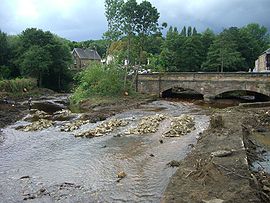
The Malin Bridge area suffered badly in the floods of June 2007. As a result of this the Environment Agency started work in August 2009 to remove trees and silt from the river beds at the confluence of the Loxley and Rivelin rivers at Malin Bridge. The work will alleviate flooding problems in the future but has had the added effect of opening up the views of the area with the confluence of the two rivers now clearly in view, something that has not been seen for many years.[13]
References
- ^ Mick Armitage‘s Sheffield Flood Site. Gives details of damage to Stag Inn and Malin Bridge Inn.
- ^ Mick Armitage‘s Sheffield Flood Site. Gives quote from “A Complete History of the Great Sheffield Flood“ by Samuel Harrison.
- ^ www.loxleyvalley.com. Gives some details of Corn Mill.
- ^ "The Complete Hillsborough By Her People", Mick Drewry (Editor), ISBN 1901 58747 9 Pages 134-140 Gives name origins and history.
- ^ Rivelin Valley Conservation Group. Gives details of Mousehole Forge.
- ^ www.anvilfire.com. Mousehole Forge book review and more details.
- ^ Burgon and Ball website. Gives history of firm.
- ^ Sheffield and District Family History Society. Parish created in 1933.
- ^ "Pevsner Architectural Guides - Sheffield", Ruth Harman & John Minnis, ISBN 0 30010585 1, Page 293 Gives architectural details for buildings.
- ^ South Yorkshire Passenger Transport Executive. Gives details of Park and Ride.
- ^ www.thetrams.co.uk. Gives some details of Supertram terminus.
- ^ Unofficial Myers Grove. Gives details of Myers Grove School.
- ^ Environment Agency Website. Gives details of flood management work.
Districts of Sheffield Abbeydale · Attercliffe · Batemoor · Beauchief · Beighton · Bradfield (High Bradfield · Low Bradfield) · Brightside · Burngreave · Carbrook · Chapeltown · Crookes · Crosspool · Darnall · Dore · Ecclesall · Ecclesfield · Fulwood · Gleadless · Greenhill · Grenoside · Halfway · Handsworth · Heeley · Hemsworth · Highfield · High Green · Hillsborough · Hyde Park · Longley · Lowfield · Loxley · Malin Bridge · Manor · Meersbrook · Middlewood · Millhouses · Mosborough · Neepsend · Nether Edge · Norton · Owlerton · Oughtibridge · Park Hill · Pitsmoor · Ranmoor · Ringinglow · Sharrow · Stocksbridge · Tinsley · Totley · Wadsley · Wadsley Bridge · Walkley · Wisewood · Woodseats · Woodhouse · Worrall
Stagecoach Sheffield Supertram
Operations OperatorsVehiclesSiemens-Duewag Supertram (fleet numbers 101-125)DepotsNunnery Square
Stations Purple LineHerdings Park · Herdings / Leighton Road · Gleadless Townend · Hollinsend · Manor Top / Elm Tree · Spring Lane · Arbourthorne Road · Park Grange · Park Grange Croft · Granville Road / The Sheffield College · Sheffield Station / Sheffield Hallam University · Fitzalan Square / Ponds Forge · Castle Square · Cathedral · Castle Square · Fitzalan Square / Ponds Forge · Hyde Park · Cricket Inn Road · Nunnery Square · Woodbourn Road · Attercliffe · Arena / Don Valley Stadium · Valley Centertainment · Carbrook · Meadowhall South / Tinsley · Meadowhall InterchangeBlue LineHalfway · Westfield · Waterthorpe · Beighton / Drake House Lane · Crystal Peaks · Moss Way · Donetsk Way · Hackenthorpe · Birley Moor Road · Birley Lane · White Lane · Gleadless Townend · Hollinsend · Manor Top / Elm Tree · Spring Lane · Arbourthorne Road · Park Grange · Park Grange Croft · Granville Road / The Sheffield College · Sheffield Station / Sheffield Hallam University · Fitzalan Square / Ponds Forge · Castle Square · Cathedral · City Hall · West Street · University of Sheffield · Netherthorpe Road · Shalesmoor · Infirmary Road · Langsett / Primrose View · Bamforth Street · Hillsborough · Malin BridgeYellow LineMiddlewood · Leppings Lane · Hillsborough Park · Hillsborough · Bamforth Street · Langsett / Primrose View · Infirmary Road · Shalesmoor · Netherthorpe Road · University of Sheffield · West Street · City Hall · Cathedral · Castle Square · Fitzalan Square / Ponds Forge · Hyde Park · Cricket Inn Road · Nunnery Square · Woodbourn Road · Attercliffe · Arena / Don Valley Stadium · Valley Centertainment · Carbrook · Meadowhall South / Tinsley · Meadowhall InterchangeProposed ExtensionsItalics indicate stations only stopped at during peak times.
Wikimedia Foundation. 2010.

