- County of Adelaide
-
Adelaide
South Australia
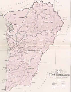
Map of Adelaide County in 1886 showing the hundredsEstablished: 2 June 1842 Area: 2955 km² Lands administrative divisions around Adelaide Gawler Light Eyre Gulf St. Vincent Adelaide Sturt Hindmarsh Hindmarsh Hindmarsh The County of Adelaide is one of the 49 counties of South Australia and contains the city of Adelaide. It was proclaimed on 2 June 1842 by Governor Grey. It is bounded by the Gawler River and North Para River in the north, the Mount Lofty Ranges in the east, Gulf St Vincent in the west, and goes as far south as near Willunga.
Hundreds
Like other counties in South Australia, it is divided into hundreds, the location, area and LGA (in the approximate area) of the hundreds is listed below:
Hundred LGA Coordinates Area Ref Adelaide City of Unley 34°56′52″S 138°37′30″E / 34.9477217°S 138.6250318°E 106 sq mi (270 km2) [1] Barossa Barossa Council 34°38′08″S 138°53′17″E / 34.6354813°S 138.8880437°E 98.5 sq mi (255 km2) [2] Kuitpo 124 sq mi (320 km2) [3] Munno Para City of Playford 34°41′44″S 138°38′35″E / 34.6956557°S 138.6431796°E 108 sq mi (280 km2) [4] Noarlunga 120 sq mi (310 km2) [5] Onkaparinga Adelaide Hills Council 34°56′03″S 138°51′59″E / 34.9341730°S 138.8662602°E [6] Para Wirra Adelaide Hills Council 34°47′21″S 138°49′34″E / 34.7892613°S 138.8260494°E 102.5 sq mi (265 km2) [7] Port Adelaide City of Playford 34°41′04″S 138°31′44″E / 34.6843747°S 138.5289062°E 68.5 sq mi (177 km2) [8] Talunga Adelaide Hills Council 34°49′05″S 138°55′26″E / 34.8179713°S 138.9239246°E 89 sq mi (230 km2) [9] Willunga 99 sq mi (260 km2) [10] Yatala City of Salisbury 34°49′50″S 138°37′42″E / 34.8305942°S 138.6284037°E 111 sq mi (290 km2) [11] References
Counties1 of Australian capital cities Categories:- Counties of South Australia
Wikimedia Foundation. 2010.
