County of Adelaide, South Australia
- County of Adelaide, South Australia
Infobox Australian cadastral
name = Adelaide
state = South Australia
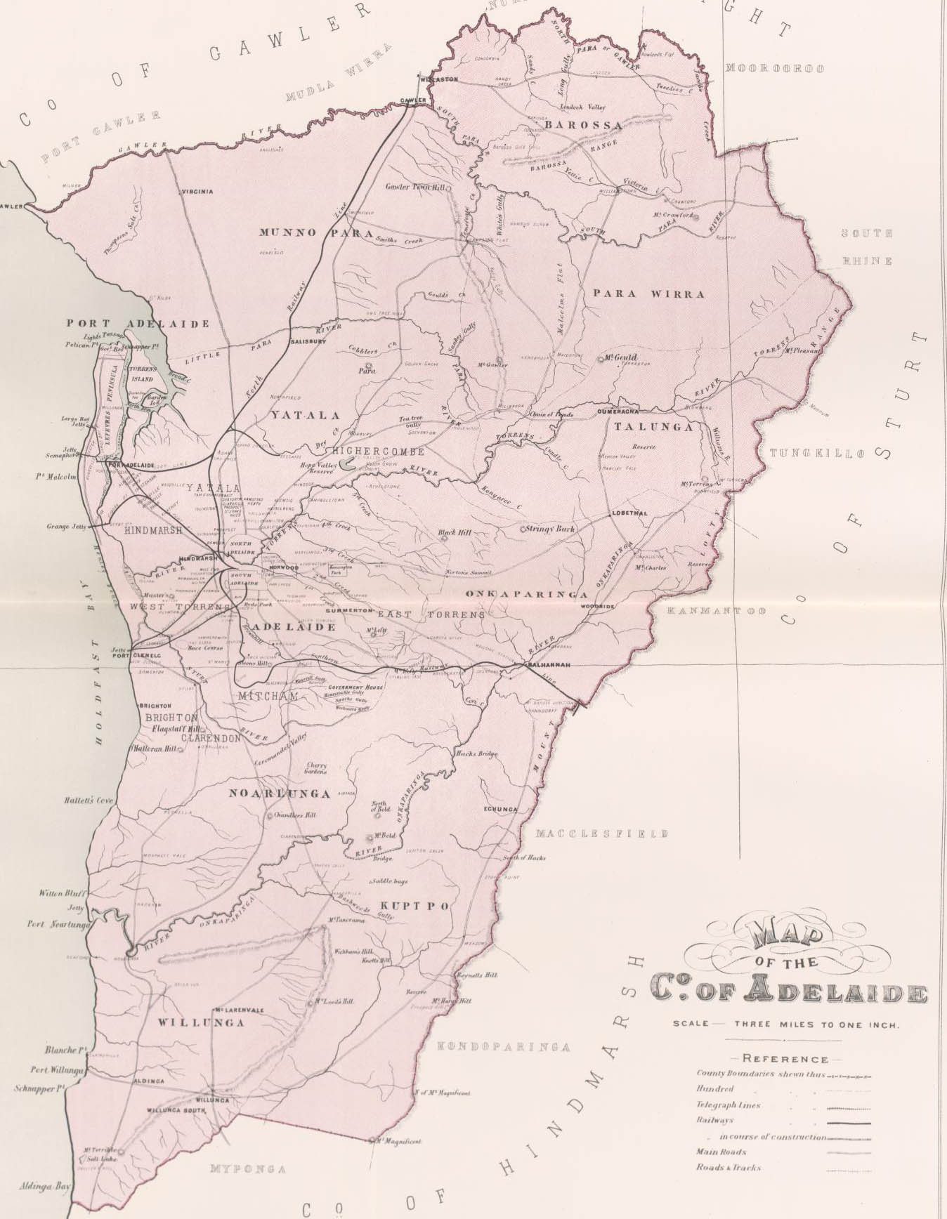
caption = Map of Adelaide County in 1886 showing the hundreds
est = 2 June 1842
area = 2955
near-nw = Gawler
near-n = Light
near-ne = Eyre
near-e = Sturt
near-se = Hindmarsh
near-s = Hindmarsh
near-sw = Hindmarsh
near-w = "Gulf St. Vincent"The County of Adelaide is one of the 49 counties of South Australia and contains the city of Adelaide. It was proclaimed on 2 June 1842 by Governor Grey. It is bounded by the Gawler River and North Para River in the north, the Mount Lofty Ranges in the east, Gulf St Vincent in the west, and goes as far south as near Willunga.
Hundreds
Like other counties in South Australia, it is divided into hundreds, the location, area and LGA (in the approximate area) of the hundreds is listed below:
References
* [http://www.placenames.sa.gov.au/pno/pnores.phtml?recno=SA0000278 Place Names SA, County of Adelaide]
Wikimedia Foundation.
2010.
Look at other dictionaries:
County of Adelaide — Adelaide South Australia Map of Adelaide County in 1886 showing the hundreds Established: 2 June 1842 Area: 2955 km² … Wikipedia
Croydon, South Australia — For other places with the same name, see Croydon (disambiguation). Croydon Adelaide, South Australia Population: 1,350 (2006 Census)[1] 1,352 … Wikipedia
Marino, South Australia — Marino Adelaide, South Australia Population: 1,986 (2006 Census)[1] Postcode: 5049 … Wikipedia
Toorak Gardens, South Australia — Infobox Australian Place | type = suburb name = Toorak Gardens city = Adelaide state = sa caption = lga = City of Burnside postcode = 5065 pop = 2,521 (2006 Census) [Census 2006 AUS|id=SSC42701|name=Toorak Gardens (State… … Wikipedia
Glandore, South Australia — Infobox Australian Place | type = suburb name = Glandore city = Adelaide state = sa caption = est = lga = City of Marion lga2 = City of West Torrens postcode = 5037 pop = 2,827 [Census 2006 AUS | id = SSC41596 | name = Glandore (State… … Wikipedia
Haslam, South Australia — Infobox Australian Place | type = town name = Haslam state = sa caption = lga = District Council of Streaky Bay postcode = 5680 est = 1893 pop = 50 elevation= 1 maxtemp = mintemp = rainfall = stategov = Flinders fedgov = Grey dist1 = 45 dir1 =… … Wikipedia
Cadastral divisions of South Australia — The Cadastral divisions of South Australia refers to the cadastral units of counties, and hundreds in South Australia. These form part of the Cadastral divisions of Australia. They are located in the south eastern part of the state and do not… … Wikipedia
Lands administrative divisions of South Australia — The 37 counties of South Australia in 1886; later 12 more were proclaimed … Wikipedia
Adelaide (disambiguation) — Adelaide is the English form of a Germanic given name, from Old High German Adalheidis nobility . The name Addie is a diminutive of Adelaide. French: Adélaïde or Adélaide ; the modern German form is Adelheid . Heidi, a nickname for Adelheid,… … Wikipedia
Cleve, South Australia — Cleve South Australia … Wikipedia