- Corpach
-
Coordinates: 56°50′35″N 5°07′23″W / 56.843°N 5.123°W
Corpach Scottish Gaelic: A' Chorpaich 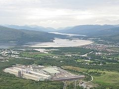
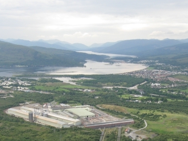
Corpach is on the right of this photo looking west up Loch Eil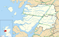
 Corpach
Corpach shown within the Lochaber areaOS grid reference NN095767 - Edinburgh 140 mi (230 km) SE - London 500 mi (800 km) SSE Council area Highland Lieutenancy area Inverness Country Scotland Sovereign state United Kingdom Post town FORT WILLIAM Postcode district PH33 Dialling code 01397 Police Northern Fire Highlands and Islands Ambulance Scottish EU Parliament Scotland UK Parliament Ross, Skye and Lochaber Scottish Parliament Inverness East, Nairn and Lochaber List of places: UK • Scotland • Corpach (Scottish Gaelic: A' Chorpaich) is a large village north of Fort William, in the Scottish Highlands. The canal lock at Corpach Basin on Loch Linnhe, east of the narrows leading to Loch Eil, is the western sea entrance of the Caledonian Canal. It is a natural harbour, unlike Fort William.
History
The name Corpach is reputedly based on the Gaelic for "field of corpses", so called because it was perhaps used as a resting place when taking coffins of chieftains on the way to burial on Iona.[1]
The Battle of Corpach in about 1470 saw Clan Cameron rout Clan MacLean.
During World War II, Corpach was the engineering base for HMS St Christopher which was a training base for Royal Navy Coastal Forces[2]. Some of the buildings are still in use. There was a large camp at Annat, now used as a caravan site. Prior to that in WWI, the US Navy had a base at Corpach as part of the laying of the Northern Barrage[3][4]. Mines were shipped into Corpach from the USA, and were then sent to the Inverness base along the Caledonian Canal, which joins Loch Linnhe at Corpach.
References
- ^ William Creech. The statistical account of Scotland: Drawn up from the communications of the ministers of the different parishes, Volume 8 (1793)
- ^ History of HMS St Christopher
- ^ The Yankee Mining Squadron or Laying the North Sea Mine Barrage, By Reginald Rowan Belknap, Published by the United States Naval Institute, 1920
- ^ The northern barrage and other mining activities, Washington, Government Printing Office 1920
External links
- Corpach on Undiscovered Scotland
- Killmallie Image Library
Settlements Ach' An Todhair • Achaphubuil • Acharacle • Achnaha • Achluachrach • Achriabhach • Ardechive • Ardshealach • Arisaig • Back of Keppoch • Ballachulish • Banavie • Blaich • Cleadale • Corpach • Corran • Druimarben • Fort William • Glenborrodale • Glencoe • Glenfinnan • Glenuig • Inverie • Kilchoan • Kilmory • Kinlochleven • Lochaline • Mallaig • Morar • Ockle • Onich • Portuairk • Roybridge • Sanna • Spean Bridge • StrontianGeography Landmarks Transport Categories:- Populated places in Lochaber

Wikimedia Foundation. 2010.