- Ockle
-
Coordinates: 56°45′40″N 6°00′07″W / 56.761°N 6.002°W
Ockle Scottish Gaelic: Ocal 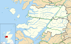
 Ockle
Ockle
Ockle shown within the Lochaber areaOS grid reference NM555705 Council area Highland Lieutenancy area Inverness Country Scotland Sovereign state United Kingdom Post town ACHARACLE Postcode district PH36 Dialling code 01972 Police Northern Fire Highlands and Islands Ambulance Scottish EU Parliament Scotland UK Parliament Ross, Skye and Lochaber Scottish Parliament Inverness East, Nairn and Lochaber List of places: UK • Scotland • Ockle (Scottish Gaelic: Ocal) is a remote hamlet, situated on the northcoast of the Ardnamurchan peninsula, Scottish Highlands and is in the Scottish council area of Highland.
Ockle lies 6 miles northeast of Kilchoan on the sourthern coast of the peninsula. It is worth norting that the public road ends in Ockle.
There is a 7.5 mile long footpath running between Ockle (NM555704) and the public road at Arivegaig(NM651677) ( 2.5 miles from Acharacle)
Settlements Ach' An Todhair • Achaphubuil • Acharacle • Achnaha • Achluachrach • Achriabhach • Ardechive • Ardshealach • Arisaig • Back of Keppoch • Ballachulish • Banavie • Blaich • Cleadale • Corpach • Corran • Druimarben • Fort William • Glenborrodale • Glencoe • Glenfinnan • Glenuig • Inverie • Kilchoan • Kilmory • Kinlochleven • Lochaline • Mallaig • Morar • Ockle • Onich • Portuairk • Roybridge • Sanna • Spean Bridge • StrontianGeography Landmarks Transport Categories:- Populated places in Lochaber
- Highland geography stubs

Wikimedia Foundation. 2010.