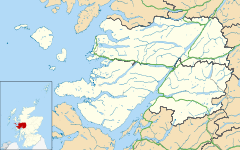
Corran, Lochaber

Corran, Lochaber

Coordinates: 56°43′24″N 5°14′57″W / 56.72347°N 5.24924°W / 56.72347; -5.24924

Corran
Scottish Gaelic: An Corran
Corran is located in Lochaber
Corran

 Corran shown within the Lochaber area
OS grid reference NN012638
Council area Highland
Lieutenancy area Inverness
Country Scotland
Sovereign state United Kingdom
Post town Fort William
Postcode district PH33 7
Police Northern
Fire Highlands and Islands
Ambulance Scottish
EU Parliament Scotland
UK Parliament Ross, Skye and Lochaber
Scottish Parliament Inverness East, Nairn & Lochaber
List of places: UK • Scotland •
The Corran landing at Ardgour

Corran (Scottish Gaelic: An Corran) is a former fishing village, situated on Corran Point, on the west side of the Corran Narrows of Loch Linnhe, in Lochaber, Highland, Scotland. There are three small settlements set apart from the main cluster of houses: North Corran, Clovullin and Sallachan.

The Highland Council Corran Ferry runs to Corran from eastern shore of the Narrows.


Wikimedia Foundation. 2010.

Игры ⚽ Нужен реферат?

Look at other dictionaries:

  • Corran — may refer to a number of places: Scotland Corran, Loch Hourn, a village in Lochalsh Corran, Lochaber, a village on Loch Linnhe Corran Ferry that plies across Loch Linnhe Corran Narrows, a narrow strait in Loch Linnhe Northern Ireland Corran,… …   Wikipedia

  • Corran Ferry — The Corran Ferry crosses Loch Linnhe at the Corran Narrows, south of Fort William, Scotland. The Corran landing at Ardgour Description Operated by Highland Council, the Corran Ferry is one of few remaining mainland vehicle ferries in Scotland …   Wikipedia

  • Nether Lochaber — Coordinates: 56°41′42″N 5°10′52″W / 56.695°N 5.181°W / 56.695; 5.181 Nether Lochaber in Lochaber …   Wikipedia

  • Morvern — Not to be confused with Morven Coordinates: 56°35′N 5°42′W / 56.59°N 5.7°W / 56.59; 5.7 …   Wikipedia

  • Kilchoan — Coordinates: 56°41′53″N 6°06′12″W / 56.698014°N 6.103306°W / 56.698014; 6.103306 …   Wikipedia

  • Kilmalie —    KILMALIE, a parish, partly in the district and county of Argyll, and partly in the county of Inverness; containing, with the village of Fort William, and the quoad sacra district of Ballichulish, 5397 inhabitants, of whom 2741 are in the… …   A Topographical dictionary of Scotland

  • Mallaig — This article is about Mallaig in Scotland. For the hamlet in Canada, see Mallaig, Alberta. Coordinates: 57°00′13″N 5°49′55″W / 57.00358°N 5.83198°W …   Wikipedia

  • Donald Cameron ('Taillear Dubh na Tuaighe') — Infobox Person name = Donald Cameron caption = birth date = 155? birth place = Scottish Highlands death date = death place = Scottish Highlands other names = Taillear Dubh na Tuaighe known for = Scottish chief of Taylor sept occupation =… …   Wikipedia

  • Taillear Dubh na Tuaighe — For other uses, see Donald Cameron. Donald Cameron Donald Cameron is alluded to in the supporters on the coat of arms of the chief of Clan Cameron Born about 1550 Other names Black Taylor of the Ax …   Wikipedia

  • Ardnamurchan — Coordinates: 56°44′N 5°59′W / 56.733°N 5.983°W / 56.733; 5.983 …   Wikipedia

Share the article and excerpts

Direct link
Do a right-click on the link above
and select “Copy Link”