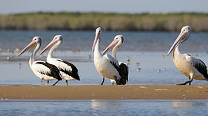
- Coongie Lakes
-
The Coongie Lakes form a complex and extensive freshwater wetland system in north-eastern South Australia which includes lakes, channels, billabongs, shallow floodplains, deltas, and interdune swamps. It lies on the floodplain of Cooper Creek, an ephemeral river flowing through a desert landscape in the Lake Eyre Basin which rarely, after occasional large floods, empties into Lake Eyre. The wetlands have been recognised as being of international importance by designation under the Ramsar Convention; the site was listed on 15 June 1987 as Ramsar site 376. It is also a World Heritage Site and, in part, an Important Bird Area (IBA) and a national park. It lies within the Innamincka Regional Reserve, about 100 km north-west of Innamincka and 1100 km north-east of Adelaide.[2][3]
Contents
Description
The Coongie Lakes Ramsar site has an area of 19,800 km2. The IBA is 593 km2, while a smaller area of 279 km2 was declared the Coongie Lakes National Park in June 2005. Land tenure is a mix of crown land, pastoral lease and national park. The surrounding region is arid and has a very low human population density; it is used mainly for cattle grazing, as well as for oil and gas production, and is becoming increasingly important for tourism. Some of the wetlands fill only on rare occasions; some contain water for a short time after periodic flooding, while others are permanent or almost permanent.[2] It lies within the traditional lands of the Yandruwandha, Yawarrawarrka, Ngamini and Dieri people.[3]
Flora and fauna
The banks and the periodically flooded areas of Cooper Creek and Coongie Lakes wetland system are vegetated by River Red Gums and Coolibahs, often with a dense understorey of Lignum thickets. The adjacent gibber plains are sparsely covered with Mitchell grass, while the dune country has species of Dodonaea, Sandhill Wattle and Sandhill Canegrass.[3]
Major floods, generally originating in heavy rainfall in western Queensland, initiate a period of rapid, opportunistic plant growth and an influx of wildlife, especially of large numbers of waterbirds such as ducks, cormorants, pelicans, ibises, spoonbills, herons and waders that aggregate to feed and breed before dispersing as the waters recede.[2] It was identified as an IBA because it supports, at times, more than 1% of the global populations of 12 species of waterbird and wader as well as significant numbers of Bourke's Parrots, Eyrean Grasswrens, Gibberbirds, Banded Whitefaces, Chirruping Wedgebills and Cinnamon Quail-thrushes.[1]
Mammals present in the area include Red Kangaroos, Dingos and, in the wetlands, Rakali. There are also a variety of frogs and reptiles, including the Inland Taipan.[3]
References
Notes
Sources
- "The Annotated Ramsar List: Australia". The Ramsar Convention on Wetlands. 2000-01-04. http://www.ramsar.org/cda/en/ramsar-pubs-annolist-annotated-ramsar-16713/main/ramsar/1-30-168%5E16713_4000_0__. Retrieved 2011-03-29.
- "Innamincka Regional Reserve and Coongie Lakes National Park". Parks brochure. Department for Environment and Heritage, South Australia. 2009-06-00. http://www.environment.sa.gov.au/files/e77987d8-c8f6-4cfc-8c9a-9e4f00b41c2d/Innamincka-Regional-Reserve-Coongie-Lakes-National-Park.pdf. Retrieved 2011-03-29.
External links
Protected areas of South Australia National Parks Belair · Canunda · Coffin Bay · Coongie Lakes · Coorong · Flinders Chase · Flinders Ranges · Gawler Ranges · Innes · Lake Eyre · Lake Gairdner · Lake Torrens · Lincoln · Mount Remarkable · Murray River · Naracoorte Caves · Nullarbor · Onkaparinga River · Vulkathunha-Gammon Ranges · Witjira
Conservation Parks Acraman Creek · Billiatt · Black Hill · Cape Gantheaume · Cleland · Cox Scrub · Danggali · Deep Creek · Fairview · Finniss · Fort Glanville · Gum Laqoon · Kelly Hill · Hacks Lagoon · Hallett Cove · Horsnell Gully · Kaiserstuhl · Lake Gilles · Mamungari · Marino · Monarto · Morialta · Mount Magnificent · Naracoorte Caves · Ngarkat · Peebinga · Piccaninnie Ponds · Scott Creek · Seal Bay · Simpson Desert · Spring Gully · Talisker
Recreation Parks Regional Reserves Innamincka · Lake Frome · Nullarbor · Simpson Desert · Strzelecki
Conservation Reserves Wilderness Protection Areas Game Reserves Coordinates: 27°09′00″S 140°11′00″E / 27.15°S 140.1833333°E
Categories:- Ramsar sites in Australia
- World Heritage Sites in Australia
- Lakes of South Australia
- Lake Eyre basin
- National parks of South Australia
- Important Bird Areas of Australia
- Far North (South Australia)
- South Australia protected area stubs
Wikimedia Foundation. 2010.

