- Brenner, South Tyrol
-
Brenner — Comune — Gemeinde Brenner
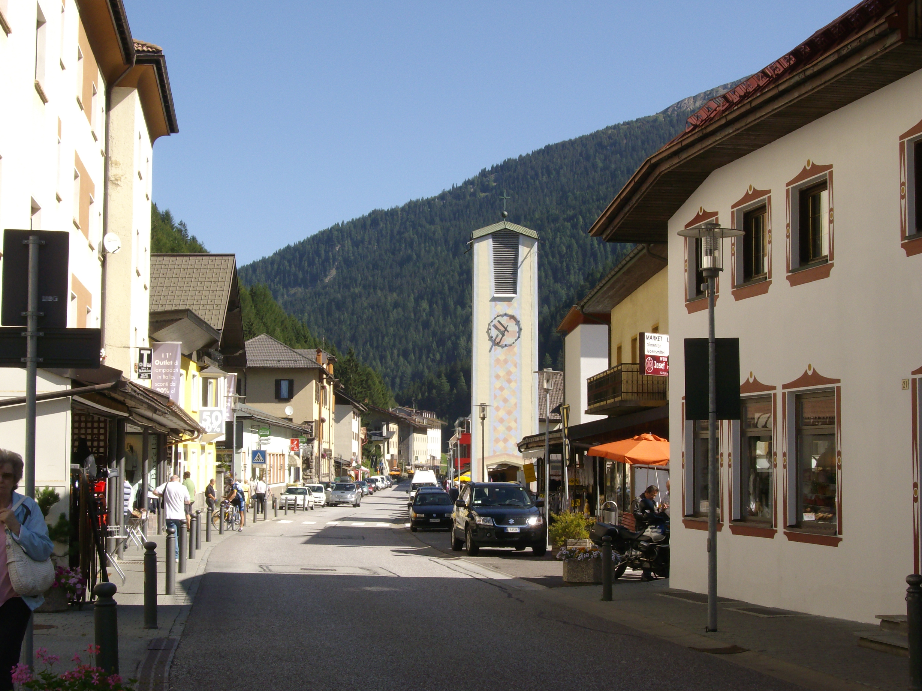
Comune di BrenneroThe main street
Coat of armsLocation of Brenner in Italy
 Brenner
Coordinates: 47°0′N 11°30′E / 47°N 11.5°ECoordinates: 47°0′N 11°30′E / 47°N 11.5°E Country Italy Region Trentino-Alto Adige/Südtirol Province South Tyrol (BZ) Frazioni Brennerbad (Terme di Brennero), Gossensaß (Colle Isarco), Pflersch (Fleres) and Pontigl (Ponticolo) Government – Mayor Franz Kompatscher Area – Total 114.1 km2 (44.1 sq mi) Population (Nov. 2010) – Total 2,085 – Density 18.3/km2 (47.3/sq mi) Time zone CET (UTC+1) – Summer (DST) CEST (UTC+2) Postal code 39041 Dialing code 0472 Website Official website Brenner (Italian: Brennero) is a comune in South Tyrol in the Trentino-Alto Adige/Südtirol region of northeast Italy.
Contents
Geography
Territory
Brenner lies about 110 km northeast of the city of Trento and about 60 km north of the city of Bolzano, on the border with Austria. The south end of the Brenner Pass is located in this municipality.
Brenner borders the following municipalities: Pfitsch, Ratschings, Sterzing, Gries am Brenner (Austria), Gschnitz (Austria), Neustift im Stubaital (Austria) and Obernberg am Brenner (Austria).
Frazioni
The municipality of Brenner contains the frazioni (parishes) of Brennerbad (Terme di Brennero ), Gossensaß (Colle Isarco), Pflersch (Fleres) and Pontigl (Ponticolo).
Gossensaß (Italian: Colle Isarco) is the main village of the municipality. It dates back 4000 years, reflecting its position as a place to prepare for the Brenner Pass. In the 15th and 16th century, Gossensaß prospered due to silver mining. Today Gossensaß benefits from the local tourism, especially during the winter when the ski resort in Ladurns is open.
History
Origin
The Breuni were a people who lived in the Eisacktal and in the Brenner region on both sides of the pass until the IX century. The place, after the Roman Conquest in 15 B.C., was called "Vallis Vipitena", and the only road was a track. The Romans built a military road in the II century, milestone of Marcus Aurelius, Septimus Severus and Caracalla period were found in the region and in the III century the Romans completed the Retica road.[1] In 565 Venantius Fortunatus mentioned in his writings the "Saint Valentine" temple that later became a church; in the Middle Ages it was restored in Romanesque style, in 1500 in Gothic than in Baroque. In the period of the barbaric migrations, approximately in 590 the region was invaded by Bavarii, the place declined but, 66 german Sovereigns of the Holy Roman Empire, from 960 to 1530 and among them, in 1154, Frederick I called Barbarossa passed through Brenner directed to the Pope in Rome.
Around in the 1000 a permanent village was settled with the name of "Oberers Mittewald" while "Prenner" is mentioned in 288.[2] During the XIV and XV centuries the village was busys with the traffic and the trade connected with the pass and a new carriage was built in 1314[3] while in 1414 the Count of Tyrol established a Customs in order to check the goods in transit. The two historic inhabited places of the village were the "Saint Valentine" church, the "Post Hotel" and few other houses on the south side, the "Kerschbaumer Hotel", "Griesberg" and "Venn" on the north, nowadays in Austria. The old carriage was enlarged and the tracing modified in 1740 in order to have a comfortable road; Goethe, on 8 September 1786, on his journey to Italy stopped in Brenner at "Post Hotel".[2]
The construction of the Brenner railway, between Innsbruck and Bozen through the Brenner Pass, began on 23 February 1864 at Bergisel (Innsbruck) and the building involved the village with hundreds of workers who lived there for three years. The railway transformed the planimetry of the village; some houses were destroyed to make room for a new area, 600 meters long, regarding the station and the other infrastructures connected with the railway itself. On 25 July 1867 at 8.05 the first train departed from Brenner station directed to Bozen though the official opening would be August 24; the railway opened a new era for the village with the arrival of travellers and tourism. At Brenner Bad (Thermal baths), few miles south of the village, a "Grand Hotel", with a train stop, was built and attracted a new class of tourists until the beginning of the first World War.
On 26 April 1915 the Treaty of London assigned to Italy the South Tyrol, from Trent to Brenner, and on 10 November 1918, at the end of the war, Italian troops arrived at Brenner. The Treaty of Saint-Germain-en-Laye was signed on 10 September 1919 and just at Brenner the new boundary line was traced.[4]
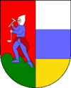
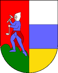
Coat-of-arms
The shield is party per pale: the first is a miner holding a hammer in his right hand and a lamp in his left, on a vert hill with a gules background; the second part is tierced per fess in argent, azure and or. The emblem was adopted in 1906.[5]
Society
Linguistic distribution
Language 1991 2001[6] German 70.49 % 79.39 % Italian 29.23 % 20.29 % Ladin 0.28 % 0.31 % Demographic evolution
Population over time :

Notes and references
- ^ Grande Dizionario Enciclopedico, Unione Tipografica - Editrice Torinese, 1962
- ^ a b Con-fine Brennero, Editrice Athesia, 2006, ISBN 88-8266-410-4
- ^ Guide d'Italia, Trentino Alto Adige, Editrice TCI, 1976
- ^ Con.fine Brennero, Editrice Athesia, 2006, ISBN 88-8266-410-4
- ^ Heraldry of the World: Brenner
- ^ Oscar Benvenuto (ed.): "South Tyrol in Figures 2008", Provincial Statistics Institute of the Autonomous Province of South Tyrol, Bozen/Bolzano 2007, p. 16, table 10
External links
- (German) (Italian) Homepage of the municipality
Categories:


Wikimedia Foundation. 2010.