- Unorganized North Cochrane District
-
Unorganized Cochrane North Part — Unorganized territory — Otter Rapids Generating Station on the Abitibi River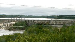

 Unorganized Cochrane North Part
Coordinates: 50°00′N 82°00′W / 50°N 82°WCoordinates: 50°00′N 82°00′W / 50°N 82°W Country  Canada
Province  Ontario
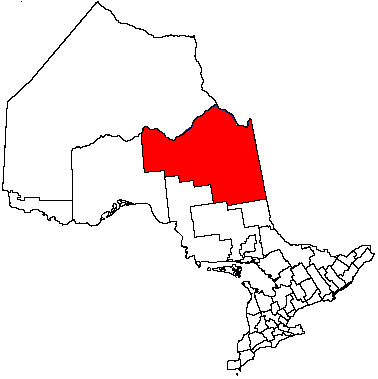
District Cochrane Settled Government – Federal riding Timmins—James Bay – Prov. riding Timmins—James Bay Area[1] – Land 131,706.99 km2 (50,852.4 sq mi) Population (2006)[1] – Total 2,447 – Density 0.0/km2 (0/sq mi) Time zone EST (UTC-5) – Summer (DST) EDT (UTC-4) Postal Code Area code(s) 705 Unorganized Cochrane North Part is an unorganized area in the District of Cochrane in northeastern Ontario, Canada. It comprises all parts of the district north of Timmins and Iroquois Falls which are not part of an incorporated municipality.
Communities
The territory includes the communities of Abitibi Canyon, Brower, Calstock, Coppell, Departure Lake, Driftwood, Eades, Fraserdale, Frederick, Gardiner, Ghost River, Hallebourg, Hunta, Jogues, Kitigan, Lac-Sainte-Thérèse, Low Bush River, Mead, Moose Factory (partial), Norembega, Pagwa River, Smoky Falls and Tunis.
Demographics
According to the Canada 2006 Census:[1]
- Population: 2,447 (2001 to 2006 population change: -24.4 %)
- Dwellings: 1,870
- Area (km².): 131,706.99
- Density (persons per km².): 0.0186
Population trend:[2]
- Population in 2006: 2447
- Population in 2001: 3237
- Population in 1996: 4187 (or 3702 when adjusted to 2001 boundaries)
- Population in 1991: 4020
Private dwellings, excluding seasonal cottages: 980 (total: 1870)
Mother tongue:[1]
- English as first language: 32.2 %
- French as first language: 64.3 %
- English and French as first language: 0.8 %
- Other as first language: 2.7 %
References
City 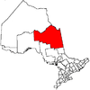
Towns Townships First Nations reserves Abitibi 70 • Constance Lake 92 • Factory Island 1 • Flying Post 73 • Fort Albany 67 • Moose Factory 68 • New Post 69 • New Post 69AUnorganized territories North Part • South East Part • South West PartSee also: Communities in Cochrane District • Census divisions of OntarioCategories:- Cochrane District, Ontario
- Unorganized areas in Ontario
- Ontario communities with large francophone populations
- Northern Ontario geography stubs


Wikimedia Foundation. 2010.