- All Saints Church, Shirburn
-
All Saints Church, Shirburn 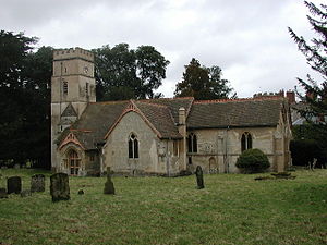
All Saints Church, Shirburn, from the southLocation in Oxfordshire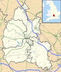
 All Saints Church, Shirburn
Coordinates: 51°39′28″N 0°59′41″W / 51.6577°N 0.9946°W OS grid reference SU 696 959 Location Shirburn, Oxfordshire Country England Denomination Anglican Website Churches Conservation Trust Architecture Functional status Redundant Heritage designation Grade II Designated 18 July 1963 Architect(s) T. H. Wyatt (1876 restoration) Architectural type Church Style Norman, Gothic, Georgian,
Gothic RevivalCompleted 1876 Specifications Materials Rendered chalk and flint
Brick north transept
Tiled roofsAll Saints Church, Shirburn, is a redundant Anglican church in the village of Shirburn, Oxfordshire, England. It has been designated by English Heritage as a Grade II listed building,[1] and is under the care of the Churches Conservation Trust.[2] The church stands at the west end of the village, immediately to the south of Shirburn Castle, the seat of the Earls of Macclesfield since 1715.[2][3] The north chapel of the church is the mausoleum of the Parker family, Earls of Macclesfield.[2]
Contents
History
The church dates from the late 11th or early 12th century. Additions and alterations were made in the 13th and 14th centuries.[1] Further alterations took place in the 18th century, when the top stage was added to the tower, and in the early part of the 19th century, when a north transept was added "as a family pew for the Earl of Macclesfield".[4] The church was restored and largely rebuilt in 1876 by T. H. Wyatt.[1] It was declared redundant in 1995 and vested in the Churches Conservation Trust.[5]
Architecture
Most of the church is constructed in rendered chalk and flint rubble, and the north transept is in brick. The roofs are tiled. Its plan is cruciform.[1] It consists of a nave with north and south aisles, north and south transepts, a south porch, a chancel with an organ chamber and a vestry to its north, and a west tower. To the south of the tower is a 19th-century circular staircase. On the north side of the tower is a two-light window which is probably Norman.[4] The top stage of the tower is Georgian in style.[1] Above the medieval west window in the bottom stage of the tower is a re-set Norman tympanum decorated with a figure-of-eight pattern. In the corresponding position inside the tower is a re-set Norman lintel, decorated with stars, beast heads and foliage. These were placed here in the 1876 restoration.[6] The dates of the windows around the church spread from the 12th to the 19th century.[1]
Inside the church are two 13th-century three-bay arcades between the nave and the aisles, and a two-bay arcade between the chancel and the north chapel. In the chancel and the transepts are memorials to the Chamberlain and Macclesfield families, and others. The south transept contains a 14th-century piscina, and in the nave is a 13th-century font with an 18th-century cover.[1] The stained glass in the east window is by Ward and Hughes.[4] The single-manual organ was made in the 1880s by Gray and Davison.[7]
See also
- List of churches preserved by the Churches Conservation Trust in South East England
References
- ^ a b c d e f g "Church of All Saints, Shirburn", The National Heritage List for England (English Heritage), 2011, http://list.english-heritage.org.uk/resultsingle.aspx?uid=1284215, retrieved 18 April 2011
- ^ a b c All Saints' Church, Shirburn, Oxfordshire, Churches Conservation Trust, http://www.visitchurches.org.uk/Ourchurches/Completelistofchurches/All-Saints-Church-Shirburn-Oxfordshire/, retrieved 27 March 2011
- ^ Shirburn, Streetmap, http://streetmap.co.uk/grid/469539_195965_120, retrieved 27 March 2011
- ^ a b c Lobel, Mary D., ed. (1964), "Parishes: Shirburn", A History of the County of Oxford, Victoria County History (University of London & History of Parliament Trust) 8: pp. 178–198, http://193.39.212.226/report.aspx?compid=63824#s7, retrieved 27 March 2011
- ^ All Saints Church, Shirburn, The Benefice of Icknield, http://www.icknield.info/allsaints.aspx, retrieved 27 March 2011
- ^ Blair, John and Sarah (2008), All Saints, Shirburn, Oxfordshire, London: Corpus of Romanesque Sculpture in Britain and Ireland, http://www.crsbi.ac.uk/search/county/site/ed-ox-shirb.html, retrieved 27 March 2011
- ^ Oxfordshire, Shirburn, All Saints (N00862), British Institute of Organ Studies, http://www.npor.org.uk/cgi-bin/Rsearch.cgi?Fn=Rsearch&rec_index=N00862#PhotoSection, retrieved 27 March 2011
External links
Categories:- Grade II listed buildings in Oxfordshire
- Grade II listed churches
- Church of England churches in Oxfordshire
- Norman architecture
- English Gothic architecture
- Georgian architecture
- Gothic Revival architecture in England
- Churches preserved by the Churches Conservation Trust
- Redundant churches


Wikimedia Foundation. 2010.