- Church of All Saints, Selworthy
-
Church of All Saints 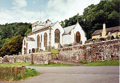
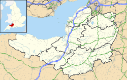
 Location within Somerset
General information Town or city Selworthy Country England Coordinates 51°12′37″N 3°32′51″W / 51.2102°N 3.5476°W Completed 15th century The Church of All Saints which sits on a hillside above Selworthy, Somerset, England is a whitewashed 15th-century Church, with a 14th-century tower. It has been designated by English Heritage as a Grade I listed building.[1]
The pulpit includes a 17th-century hourglass and the iron-bound parish chest dates from the same time.[2] Within the church is a copy of the Chained Book of 1609 by Bishop John Jewel, entitled Defense of the Apologie of the Church of England.[3]
In the churchyard is a medieval cross with three octagonal steps, a square socket, and an octagonal shaft. The head is missing.[4][5] The churchyard provides views across the valley to Dunkery Beacon.[6]
See also
- List of Grade I listed buildings in West Somerset
- List of towers in Somerset
References
- ^ "Church of All Saints". Images of England. http://www.imagesofengland.org.uk/details/default.aspx?id=265524. Retrieved 2008-01-26.
- ^ "Selworthy". Pictures of England. http://www.picturesofengland.com/England/Somerset/Selworthy_Green. Retrieved 2008-01-26.
- ^ "Selworthy". Everything Exmoor. http://www.everythingexmoor.org.uk/_S/Selworthy.php. Retrieved 2008-01-26.
- ^ Adkins, Lesley; Roy Adkins (1992). A Field Guide to Somerset Archaeology. Wimborne, Dorset: Dovecote Press. pp. 101. ISBN 0946159947.
- ^ "Remains of churchyard cross". Images of England. http://www.imagesofengland.org.uk/details/default.aspx?id=265525. Retrieved 2008-01-26.
- ^ Dunning, Robert (1980). Somerset and Avon. Edinburgh: John Bartholomew & Son. pp. 125. ISBN 0702883808.
Categories:- Church of England churches in Somerset
- 15th-century architecture
- Grade I listed churches
- Grade I listed buildings in Somerset
- West Somerset


Wikimedia Foundation. 2010.