- Church Cove
-
Coordinates: 49°58′11″N 5°11′37″W / 49.9696°N 5.1936°W
Church Cove
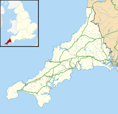
 Church Cove shown within Cornwall
OS grid reference SW711125 Unitary authority Cornwall Ceremonial county Cornwall Region South West Country England Sovereign state United Kingdom Post town HELSTON Postcode district TR12 Dialling code 01326 Police Devon and Cornwall Fire Cornwall Ambulance South Western EU Parliament South West England UK Parliament St Ives List of places: UK • England • Cornwall Church Cove is a hamlet in the civil parish of Landewednack in Cornwall, England. Its nearest town is Helston, which lies approximately 10.1 miles (16.3 km) north-west from the hamlet. The parish is notable for being the most southern point on British mainland.[1]
Parts of the hamlet lie within Caerthillian to Kennack SSSI (Site of Special Scientific Interest).[2]
References
- ^ Ordnance Survey: Explorer map sheet 103 The Lizard ISBN 9780319241172
- ^ "Caerthillian to Kennack map". Natural England. http://www.natureonthemap.naturalengland.org.uk/map.aspx?map=sssi&feature=1004373,sssi,HYPERLINK,LABEL. Retrieved 17 November 2011.
Geography of Cornwall Unitary authorities Major settlements Bodmin • Bude • Callington • Camborne • Camelford • Falmouth • Fowey • Hayle • Helston • Launceston • Liskeard • Looe • Lostwithiel • Marazion • Newlyn • Newquay • Padstow • Par • Penryn • Penzance • Porthleven • Redruth • Saltash • St Austell • St Blazey • St Columb Major • St Ives • St Just-in-Penwith • St Mawes • Stratton • Torpoint • Truro • Wadebridge
See also: Civil parishes in CornwallRivers Topics History • Status debate • Flag • Culture • Places • People • The Duchy • Diocese • Politics • Hundreds/shires • Places of interest • full list...Categories:- Hamlets in Cornwall
- Cornwall geography stubs
Wikimedia Foundation. 2010.

