- Kefalonia Prefecture
-
Kefallinia
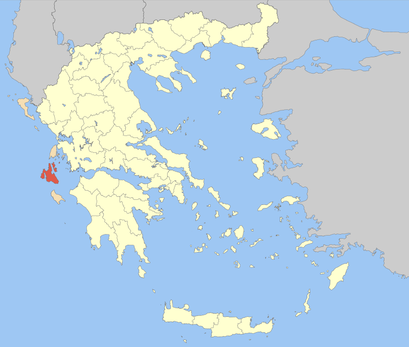
Νομός Κεφαλληνίας— Former prefecture — Location of Kefallinia in Greece Location of municipalities within Kefallinia Prefecture
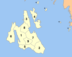
Country Greece Periphery Ionian Islands Capital Argostoli Subdivisions List- 3 provinces
- 8 municipalities
- 1 community
Area – Total 904 km2 (349 sq mi) Area rank 49th Population (2005) – Total 42,088 – Rank 50th – Density 46.6/km2 (120.6/sq mi) – Density rank 33rd Postal codes 28x xx Area codes 267x0 ISO 3166 code GR-23 Website www.kefalonia.eu The Cephalonia Prefecture (Greek: Νομός Κεφαλληνίας) was a prefecture in Greece, containing the Ionian islands of Cephalonia and Ithaca. In 2011 the prefectural self-government was abolished and the territory is now covered by the peripheral units of Cephalonia and Ithaca.
Provinces
It was previously divided into 3 eparchies (provinces), and one independent municipality, Ithaca:
- Krani Province - Argostoli
- Paliki Province - Lixouri
- Sami Province - Sami
Municipalities
The prefecture was divided into eight municipalities and one community:
All of the preceding are on on the Cephalonia island, except Ithaca, which is on its own island of the same name.
External links
Prefectures of Greece Achaea and Elis (1833) · Achaea (1899) · Adrianople (1920)‡ · Aetolia-Acarnania (1833) · Arcadia (1833) · Argolis and Corinthia (1833) · Argolis (1899) · Argyrokastron (1915)§ · Arta (1882) · Attica and Boeotia (1833) · Attica (1899) · Boeotia (1899) · Chalkidiki (1915) · Chania (1912) · Chios (1915) · Corfu (1864) · Corinthia (1899) · Cyclades (1833) · Dodecanese (1947) · Drama (1915) · Elis (1899) · Euboea (1833) · Evros (1920) · Evrytania (1899) · Florina (1915) · Grevena (1964) · Heraklion (1912) · Imathia (1947) · Ioannina (1915) · Kallipolis (1920)‡ · Karditsa (1899) · Kastoria (1941) · Kavala (1915) · Kefallinia (1864) · Kilkis (1934) · Korytsa (1915)§ · Kozani (1915) · Lacedaemon (1899) · Laconia (1833) · Lakoniki (1899) · Larissa (1882) · Lasithi (1912) · Lefkada (1864) · Lesbos (1915) · Magnesia (1899) · Messenia (1833) · Pella (1930) · Phocis and Locris (1833) · Phocis (1899) · Phthiotis and Phocis (1845) · Phthiotis (1899) · Pieria (1947) · Piraeus (1964) · Preveza (1915) · Rethymno (1912) · Rhaedestos (1920)‡ · Rhodope (1920) · Samos (1915) · Saranta Ekklisies (1920)‡ · Serres (1915) · Sfakia (1912) · Thesprotia (1937) · Thessaloniki (1914) · Trikala (1882) · Trifylia (1899) · Xanthi (1944) · Zakynthos (1864)
From 1971, Attica Prefecture consisted of four prefecture-level units: Athens, East Attica, Piraeus, West Attica
From 1994, the prefectures of Athens and Piraeus; Drama, Kavala and Xanthi; Rhodope and Evros; were grouped intro super-prefecturesdates of first establishment in parentheses
today outside Greece: § in Northern Epirus ‡ in Eastern ThraceCategories:- Prefectures of Greece
- 1864 establishments in Greece

Wikimedia Foundation. 2010.