- Temse
-
Temse 
Flag
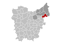
Coat of armsLocation in Belgium Coordinates: 51°07′N 04°12′E / 51.117°N 4.2°E Country Belgium Region Flemish Region Community Flemish Community Province East Flanders Arrondissement Sint-Niklaas Government - Mayor Luc De Ryck (CD&V) - Governing party/ies CD&V, VLD Area - Total 39.92 km2 (15.4 sq mi) Population (1 January 2010)[1] - Total 28,147 - Density 705.1/km2 (1,826.2/sq mi) Demographics - Foreigners 3.22% (7 January 2005) Postal codes 9140 Area codes 03 Website www.temse.be Temse is a municipality located in Flanders, one of the three regions of Belgium, and in the Flemish province of East Flanders. The municipality comprises the towns of Elversele, Steendorp, Temse proper and Tielrode. On January 1, 2006 Temse had a total population of 26,287. The total area is 39.92 km² which gives a population density of 659 inhabitants per km². The name Temse is derived from the Gallo-Roman/Gaul 'Tamisiacum' or 'Tamasiacum'. This is also reflected by the French name for the town 'Tamise', used until early in the 20th century.
References
- ^ Population per municipality on 1 January 2010 (XLS; 221 KB)
External links
- Official website - Only available in Dutch
Municipalities in the Province of East Flanders, Flanders, Belgium Aalst Aalst · Denderleeuw · Erpe-Mere · Geraardsbergen · Haaltert · Herzele · Lede · Ninove · Sint-Lievens-Houtem · Zottegem
Dendermonde Berlare · Buggenhout · Dendermonde · Hamme · Laarne · Lebbeke · Waasmunster · Wetteren · Wichelen · ZeleEeklo Ghent Aalter · Deinze · De Pinte · Destelbergen · Evergem · Gavere · Ghent · Knesselare · Lochristi · Lovendegem · Melle · Merelbeke · Moerbeke · Nazareth · Nevele · Oosterzele · Sint-Martens-Latem · Waarschoot · Wachtebeke · Zomergem · ZulteOudenaarde Brakel · Horebeke · Kluisbergen · Kruishoutem · Lierde · Maarkedal · Oudenaarde · Ronse · Wortegem-Petegem · Zingem · ZwalmSint-Niklaas Categories:- Municipalities of East Flanders
- East Flanders geography stubs
Wikimedia Foundation. 2010.


