- Denderleeuw
-
Denderleeuw 
Flag
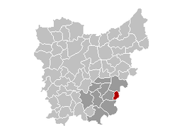
Coat of armsLocation in Belgium Coordinates: 50°53′N 04°04′E / 50.883°N 4.067°E Country Belgium Region Flemish Region Community Flemish Community Province East Flanders Arrondissement Aalst Government - Mayor Georges Couck (sp.a) - Governing party/ies sp.a, CD&V Area - Total 13.77 km2 (5.3 sq mi) Population (1 January 2010)[1] - Total 18,485 - Density 1,342.4/km2 (3,476.8/sq mi) Postal codes 9470, 9472, 9473 Area codes 053 Website www.denderleeuw.be Denderleeuw is a municipality located in the Belgian province of East Flanders in the Denderstreek. The municipality comprises the towns of Denderleeuw proper, Iddergem and Welle. On January 1, 2006 Denderleeuw had a total population of 17,357. The total area is 13.77 km² which gives a population density of 1260 inhabitants per km². The current mayor of Denderleeuw is Jo Fonck, from the SP-A (Social-Democratic) party.
References
- ^ Population per municipality on 1 January 2010 (XLS; 221 KB)
External links
- Official website (Dutch)
Municipalities in the Province of East Flanders, Flanders, Belgium Aalst Aalst · Denderleeuw · Erpe-Mere · Geraardsbergen · Haaltert · Herzele · Lede · Ninove · Sint-Lievens-Houtem · Zottegem
Dendermonde Berlare · Buggenhout · Dendermonde · Hamme · Laarne · Lebbeke · Waasmunster · Wetteren · Wichelen · ZeleEeklo Ghent Aalter · Deinze · De Pinte · Destelbergen · Evergem · Gavere · Ghent · Knesselare · Lochristi · Lovendegem · Melle · Merelbeke · Moerbeke · Nazareth · Nevele · Oosterzele · Sint-Martens-Latem · Waarschoot · Wachtebeke · Zomergem · ZulteOudenaarde Brakel · Horebeke · Kluisbergen · Kruishoutem · Lierde · Maarkedal · Oudenaarde · Ronse · Wortegem-Petegem · Zingem · ZwalmSint-Niklaas Categories:- Municipalities of East Flanders
- East Flanders geography stubs
Wikimedia Foundation. 2010.


