- Davenport Skybridge
-
Davenport Skybridge 
Carries Pedestrians Crosses River Drive (Highway 67) Locale Davenport, Iowa Design Cable-Stayed Total length 575 feet Height 50 feet Construction cost $7 million 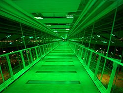 Inside the skybridge, lit up at night.
The Davenport Skybridge is a pedestrian cable-stayed bridge[1] that spans River Drive (Highway 67) in downtown Davenport, Iowa. It connects LeClaire Park and Rhythm City Casino to a courtyard and parking ramp on 2nd Street, located right next to the River Music Experience. The bridge is 50 feet tall and 575 feet long, and was completed in 2005. It was designed by Holabird & Root and Neumann Monson, P.C.
At the south end, facing the river, is an observation deck with a view of the Mississippi River, LeClaire Park Bandshell, the Centennial Bridge, and the Davenport Levee, where many festivals take place throughout the warmer months.
The inside of the Skybridge contains kaleidoscope lighting. The lighting consists of 228 LED fixtures and 8,036 individual lights. The LEDs are capable of displaying various patterns. The lighting color and patterns can be adjusted for events occurring in the area, such as a red, white, and blue color scheme for the 4th of July; red and green for Christmas; and various other patterns.
The Skybridge was a component of the Riverfront/Downtown Davenport improvement program, River Renaissance. The total cost of the structure was $7 million. Iowa taxpayers provided $3.5 million in the form of a Vision Iowa grant, Rhythm City Casino paid $2 million, and the City of Davenport taxpayers spent $500,000 for its initial construction. The Riverboat Development Authority, the agency responsible for distributing some of the taxes collected from Rhythm City, allocated $1.3 million. The bridge's stated purpose is to serve as a tourism attraction with a unique vantage point of the Mississippi River, while also functioning as a safe way to cross the highway.
References
External links
- Construction Photos of the Davenport Skybridge
- Quad-City Times articles about the Davenport Skybridge
Coordinates: 41°31′12″N 90°34′30″W / 41.52°N 90.575°W
Quad Cities and surrounding metropolitan area of Iowa and Illinois Iowa Illinois - Henry County
- Mercer County
- Rock Island County
- Rock Island
- Moline
- East Moline
- Aledo
- Annawan
- Andalusia
- Barstow
- Bishop Hill
- Buffalo Prairie
- Cambridge
- Carbon Cliff
- Cleveland
- Coal Valley
- Colona
- Coyne Center
- Dayton
- Edgington
- Galva
- Geneseo
- Green River
- Hampton
- Hillsdale
- Hooppole
- Kewanee
- Illinois City
- Milan
- Nekoma
- Oak Grove
- Orion
- Ophiem
- Osco
- Port Byron
- Reylonds
- Swedona
- Silvis
- Woodhull
Attractions - Davenport Skybridge
- Figge Art Museum
- i wireless Center
- Jumer's Casino & Hotel
- Modern Woodmen Park
- Niabi Zoo
- NorthPark Mall
- Isle of Capri Casinos
- Putnam Museum and IMAX Theater
- River Music Experience
- SouthPark Mall
- TPC at Deere Run
Colleges Historical Places Davenport, Iowa City and Government History | Neighborhoods | National Register of Historic Places: Downtown, East, West | City Hall | Scott County Court House | U.S. Court House
Landmarks Education Transportation Neighborhoods College Square | Cork Hill | Crescent Warehouse | Hamburg | McClellan Heights | Prospect Park | Riverview Terrace | Vander Veer Park | West Third Street
Other Bix 7 | Credit Island | Lock and Dam No. 15 | Vander Veer Park | African Americans
Categories:- Cable-stayed bridges in the United States
- Pedestrian bridges in Iowa
- Visitor attractions in Davenport, Iowa
- Transportation in Davenport, Iowa
- Bridges completed in 2005
- Buildings and structures in Davenport, Iowa

Wikimedia Foundation. 2010.