- Cumings, Texas
-
Cumings, Texas — CDP — 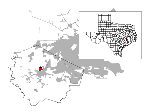
Coordinates: 29°34′25″N 95°48′12″W / 29.57361°N 95.80333°WCoordinates: 29°34′25″N 95°48′12″W / 29.57361°N 95.80333°W Country United States State Texas County Fort Bend Area - Total 3.1 sq mi (8.0 km2) - Land 3.0 sq mi (7.8 km2) - Water 0.1 sq mi (0.2 km2) Elevation 85 ft (26 m) Population (2000) - Total 683 - Density 225.6/sq mi (87.1/km2) Time zone Central (CST) (UTC-6) - Summer (DST) CDT (UTC-5) FIPS code 48-18134[1] GNIS feature ID 1852696[2] Cumings is a census-designated place (CDP) in Fort Bend County, Texas, United States. The population was 683 at the 2000 census.
Contents
Geography
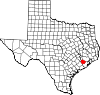
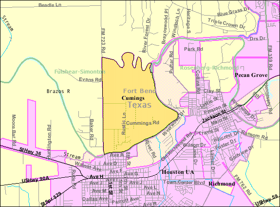
 Map of Cumings
Cumings is located at 29°34′25″N 95°48′12″W / 29.57361°N 95.80333°W (29.573483, -95.803286)[3].
According to the United States Census Bureau, the CDP has a total area of 3.1 square miles (8.0 km2), of which, 3.0 square miles (7.8 km2) of it is land and 0.1 square miles (0.26 km2) of it (2.26%) is water.
Demographics
As of the census[1] of 2000, there were 683 people, 172 households, and 156 families residing in the CDP. The population density was 225.6 people per square mile (87.0/km²). There were 186 housing units at an average density of 61.4 per square mile (23.7/km²). The racial makeup of the CDP was 60.76% White, 0.29% Asian, 35.43% from other races, and 3.51% from two or more races. Hispanic or Latino of any race were 91.65% of the population.
There were 172 households out of which 50.6% had children under the age of 18 living with them, 70.9% were married couples living together, 13.4% had a female householder with no husband present, and 9.3% were non-families. 8.1% of all households were made up of individuals and 2.9% had someone living alone who was 65 years of age or older. The average household size was 3.97 and the average family size was 4.16.
In the CDP the population was spread out with 34.8% under the age of 18, 13.0% from 18 to 24, 29.6% from 25 to 44, 16.7% from 45 to 64, and 5.9% who were 65 years of age or older. The median age was 27 years. For every 100 females there were 98.5 males. For every 100 females age 18 and over, there were 99.6 males.
The median income for a household in the CDP was $36,316, and the median income for a family was $36,776. Males had a median income of $25,847 versus $16,641 for females. The per capita income for the CDP was $10,399. About 24.0% of families and 20.5% of the population were below the poverty line, including 14.7% of those under age 18 and 56.8% of those age 65 or over.
Education
Cumings is within the Lamar Consolidated Independent School District.
Zoned schools include:[4]
- Jackson Elementary School
- Briscoe Junior High School
- Foster High School
References
- ^ a b "American FactFinder". United States Census Bureau. http://factfinder.census.gov. Retrieved 2008-01-31.
- ^ "US Board on Geographic Names". United States Geological Survey. 2007-10-25. http://geonames.usgs.gov. Retrieved 2008-01-31.
- ^ "US Gazetteer files: 2010, 2000, and 1990". United States Census Bureau. 2011-02-12. http://www.census.gov/geo/www/gazetteer/gazette.html. Retrieved 2011-04-23.
- ^ "Maps of LCISD." Lamar Consolidated Independent School District.
External links
Municipalities and communities of Fort Bend County, Texas Cities Arcola | Beasley | Fulshear | Houston‡ | Katy‡ | Kendleton | Meadows Place | Missouri City‡ | Needville | Orchard | Pearland‡ | Richmond | Rosenberg | Simonton | Stafford‡ | Sugar Land | Weston Lakes
Town Villages CDPs Cinco Ranch‡ | Cumings | Fifth Street | Four Corners | Fresno | Greatwood | Mission Bend‡ | New Territory | Pecan Grove | Sienna Plantation
Unincorporated
communitiesBooth | Crabb | Clodine | Foster | Guy | Juliff | Long Point | Pittsville | Powell Point | Tavener
Footnotes ‡This populated place also has portions in an adjacent county or counties
Categories:- Cities in Texas
- Populated places in Fort Bend County, Texas
- Census-designated places in Texas
- Populated places in Texas with Hispanic majority populations
- Greater Houston


Wikimedia Foundation. 2010.