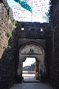
- Naldurg
-
Naldurg — city — Coordinates 17°49′N 76°18′E / 17.82°N 76.3°ECoordinates: 17°49′N 76°18′E / 17.82°N 76.3°E Country India State Maharashtra District(s) Osmanabad Population
• Density
15,993 (2001[update])
• 7,550 /km2 (19,554 /sq mi)
Sex ratio 52%/48% ♂/♀ Time zone IST (UTC+05:30) Area
7,550 square kilometres (2,920 sq mi)
• 566 metres (1,857 ft)
Naldurg is a city and a municipal council in Osmanabad district in the Indian state of Maharashtra.
As of 2001[update] India census[1], Naldurg had a population of 15,993. Males constitute 52% of the population and females 48%. Naldurg has an average literacy rate of 64%, higher than the national average of 59.5%: male literacy is 71%, and female literacy is 57%. In Naldurg, 16% of the population is under 6 years of age.
Contents
Geography
Naldurg is located at 17°49′N 76°18′E / 17.82°N 76.3°E[2]. It has an average elevation of 566 metres (1856 feet). The town has one main airport, one railway station and ST buses.
- Area: 7550 km²
- Sub-divisions: 2 (Osmanabad, Bhum)
- Talukas: 8 (Osmanabad, Tuljapur,Lohara, Umarga, Kalamb, Bhum, Paranda, Vashi)
- Distance from Mumbai: 438 km
History
The Naldurg fort is one of the important ground forts in the Marathawada region. It represents a fine example of the medieval architectural style.
It is believed that the fort was built by Nalaraja (The King Nala). The fort and the city is named after him. The fort was built in the period of the Chalukya kings of Kalyani. Later, from 1351 to 1480, in the period of the Bahamani kings and in 1558, the Adil Shahi rulers constructed the massive fortification wall of the fort. In 1613, Ibrahim Adilshah II built the weir on the river Bori and constructed Pani Mahal.
The main entrance gate of the fort is known as Hulmukh Darwaza. The protective walls have 115 massive bastions. The chief bastions are named Paranda, Upli, Sangram and Nav Buruj. Upli Burug is the highest place in the fort. Cannons are placed on these bastions to this day.
These cannons have figures of elephants and crocodiles and are therefore called Hathi Thop and Magar Thop. There are some old buildings still standing in good condition.
Agriculture
- Area under irrigation: 1186.76 km²
- Medium projects: 17
- Minor projects: 120
- Imp. Projects: 1 (Lower Terna)
- Area under horticulture: 14.6 km²
Main crops are jowar, bajra, and tur.
Weather
Temperature
- Max. - 43.1 °C
- Min. - 10.1 °C
Rainfall
760 mm (average)
Languages/dialects
Marathi/urdu/Hindi/Kannad
Folk arts
Bhajan, Kirtan, Jogwa, Gondhal
Infrastructure
Heath
- PHCs - 1
- Rural Hospitals - 12
- District Hospitals - 42
Industry
- Big - 6
- Medium - 4
- Small - 902
Educational institutions
- Colleges - 302
- Primary Schools - 1055
- Secondary Schools - 303
Cultural highlights
Tulja Bhavani, revered deity of Maharashtra, at whose feet Chhatrapati Shivaji Maharaj received inspiration to establish Hindvi Swaraj, is at Tuljapur and is in this district in which Shree Sant Goroba was born. Naldurg fort is an architectural marvel and its palace below the water attracts tourists and researchers alike, even after five centuries. The Osmanabad goat is a tough breed, always in demand by farmers across the country. Umarga and Sastoor were uprooted in the massive earthquake of 1993. They have risen again from the ruins, just like the Phoenix, highlighting the courage of the people of the district.
Temples
- Khandoba Mandir
- Shree 1008 Bhagwan Adhinath Mandir
- Ambabai Mandir
- Rokdya Maruti Mandir
- Ganesh Mandir
- Vithal Rukumini Mandir
- Mahadev Mandir
- Dargah Hajrat Sayyed Sadik Shah Wali(R.A)
- Dargah Hajrat Sayyeda Nanima sarkar(R.A)
- Dargah Hajrat Sayyed Burhan Shah Wali(R.A)
Tourist places
- Tuljapur
- Naldurg fort
- Akkalkot
References
- ^ "Census of India 2001: Data from the 2001 Census, including cities, villages and towns (Provisional)". Census Commission of India. Archived from the original on 2004-06-16. http://web.archive.org/web/20040616075334/http://www.censusindia.net/results/town.php?stad=A&state5=999. Retrieved 2008-11-01.
- ^ Falling Rain Genomics, Inc - Naldurg
Categories:- Forts in Maharashtra
- Cities and towns in Osmanabad district
Wikimedia Foundation. 2010.


