Oyster Bay, Eastern Cape

Oyster Bay, Eastern Cape
Oyster Bay
—  Town  —
The eastern side of the bay
Oyster Bay is located in Eastern Cape
Oyster Bay
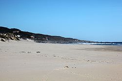
Location of Oyster Bay
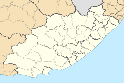
Coordinates: 34°10′10″S 24°39′15″E / 34.16944°S 24.65417°E / -34.16944; 24.65417Coordinates: 34°10′10″S 24°39′15″E / 34.16944°S 24.65417°E / -34.16944; 24.65417
Country South Africa
Province Eastern Cape
District Municipality Cacadu
Local Municipality Kouga
Time zone SAST (UTC+2)

Oyster Bay (Afrikaans Oesterbaai) is a small coastal hamlet and resort located about 14 km west of St Francis Bay on the Eastern Cape Coast of South Africa. It forms part of the Kouga Local Municipality of the Cacadu District in the Eastern Cape.


Wikimedia Foundation. 2010.

Игры ⚽ Нужна курсовая?

Look at other dictionaries:

  • Oyster Bay — may refer to: Place names In Australia Oyster Bay, New South Wales, a suburb of Sydney, Australia Great Oyster Bay, a bay on the east coast of Tasmania, Australia In South Africa Oyster Bay, Eastern Cape, South Africa, a small coastal hamlet and… …   Wikipedia

  • List of cities and towns in the Eastern Cape — This is a list of cities and towns in the Eastern Cape province of South Africa.The Amatola Region* Adelaide * Alice * Balfour * Berlin * Bhisho, (previously Bisho) * Braunschweig * Cathcart * Dohne * Dordrecht * East London(eMonti) * Elliot *… …   Wikipedia

  • Eastern oyster — Oyster bed on Cockspur Island, Georgia, USA Scientific classification Kingdom …   Wikipedia

  • Oyster, Virginia — Sign at Oyster docks Oyster is a small unincorporated community on the Atlantic Coast of the Eastern Shore of the U.S. state of Virginia in Northampton County. It is at an elevation of 3 feet (1 m) above sea level. Coordinates …   Wikipedia

  • Oyster — For other uses, see Oyster (disambiguation). Crassostrea gigas from the Marennes Oléron basin in France The word oyster is used as a common name for a number of distinct groups of bivalve molluscs which live in marine or brackish habitats. The… …   Wikipedia

  • Chesapeake Bay — Coordinates: 36°59′45″N 75°57′34″W / 36.99583°N 75.95944°W / 36.99583; 75.95944 …   Wikipedia

  • Chesapeake Bay National Estuarine Research Reserve (Virginia) — Coordinates: 37°26′3″N 76°43′15″W / 37.43417°N 76.72083°W / 37.43417; 76.72083 …   Wikipedia

  • Aboriginal Tasmanians — This article is about the indigenous people of the island state of Van Diemen s Land (Tasmania). For other indigenous people see Indigenous peoples (disambiguation) Parlevar (Eng:Palawa) (Tasmanian Aborigines) Regions with significant populations …   Wikipedia

  • Lighthouses in the United States — This United States has hundreds of lights as well as light towers, range lights, and pier head lights. Michigan has the most lights of any state with over 130. See also: Lightvessels in the United States, lightvessel, List of lighthouses and… …   Wikipedia

  • Geology of Tasmania — Tasmania has a varied geological history, with the world s biggest exposure of diabase, or dolerite. Rocks from the Neoproterozoic, Paleozoic and Mesozoic time periods appear. It is one of the few southern hemisphere areas glaciated during the… …   Wikipedia

Share the article and excerpts

Direct link
Do a right-click on the link above
and select “Copy Link”