Crostwick

Crostwick

Coordinates: 52°41′50″N 1°20′24″E / 52.69724°N 1.34011°E / 52.69724; 1.34011

Crostwick
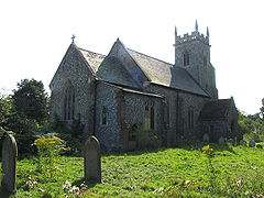
St Peter, Crostwick, Norfolk - geograph.org.uk - 318943.jpg
St Peter's Church, Crostwick
Crostwick is located in Norfolk
Crostwick

 Crostwick shown within Norfolk
Area  2.82 km2 (1.09 sq mi)
Population 97 (2001 census[1])
    - Density  34 /km2 (88 /sq mi)
OS grid reference TG257162
Parish Crostwick
District Broadland
Shire county Norfolk
Region East
Country England
Sovereign state United Kingdom
Post town NORWICH
Postcode district NR12
Police Norfolk
Fire Norfolk
Ambulance East of England
EU Parliament East of England
List of places: UK • England • Norfolk

Crostwick is a village and civil parish in the district of Broadland, Norfolk, England.

Notes

  1. ^ Census population and household counts for unparished urban areas and all parishes. Office for National Statistics & Norfolk County Council (2001). Retrieved 20 June 2009.

External links

Media related to Crostwick at Wikimedia Commons


Wikimedia Foundation. 2010.

Игры ⚽ Нужна курсовая?

Look at other dictionaries:

  • Crostwight — Coordinates: 52°48′54″N 1°28′23″E / 52.815006°N 1.473069°E / 52.815006; 1.473069 …   Wikipedia

  • Coltishall — Coordinates: 52°43′41″N 1°21′43″E / 52.7281°N 1.36189°E / 52.7281; 1.36189 …   Wikipedia

  • Belaugh — Coordinates: 52°42′58″N 1°23′14″E / 52.716019°N 1.387196°E / 52.716019; 1.387196 …   Wikipedia

  • Acle — Coordinates: 52°38′17″N 1°33′18″E / 52.638°N 1.555°E / 52.638; 1.555 …   Wikipedia

  • Broadland — is a local government district in Norfolk, England, named after the Norfolk Broads. Its council is based in Thorpe St Andrew, which is a suburb of the City of Norwich.HistoryThe district was formed on April 1, 1974 by the merger of St. Faiths and …   Wikipedia

  • Taverham — Coordinates: 52°41′N 1°12′E / 52.68°N 1.20°E / 52.68; 1.20 …   Wikipedia

  • Old Catton — Coordinates: 52°39′40″N 1°18′08″E / 52.6611°N 1.3023°E / 52.6611; 1.3023 …   Wikipedia

  • List of places in Norfolk — This is a list of cities, towns and villages in the ceremonial and shire county of Norfolk, England. See the list of places in England for places in other counties. Contents Top 0–9 A B C D E F G H I J K L M N O P Q R S T U V W X Y Z NOTOC A*Acle …   Wikipedia

  • List of civil parishes in Norfolk — This is a list of civil parishes in the county of Norfolk, England. It is broken down by the seven local authority districts that make up the county.BrecklandBreckland is entirely parished, and comprises the following parishes:*Ashill… …   Wikipedia

  • Lingwood and Burlingham — Coordinates: 52°37′30″N 1°29′28″E / 52.625°N 1.491°E / 52.625; 1.491 …   Wikipedia

Share the article and excerpts

Direct link
Do a right-click on the link above
and select “Copy Link”