- Hemblington
-
Coordinates: 52°39′01″N 1°28′38″E / 52.6503°N 1.4772°E
Hemblington 
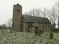
Hemblington All Saints in the snow
 Hemblington shown within Norfolk
Area 3.03 km2 (1.17 sq mi) Population 316 - Density 104 /km2 (270 /sq mi) OS grid reference TG353115 Parish Hemblington District Broadland Shire county Norfolk Region East Country England Sovereign state United Kingdom Post town NORWICH Postcode district NR13 Police Norfolk Fire Norfolk Ambulance East of England EU Parliament East of England List of places: UK • England • Norfolk Hemblington is a civil parish in the English county of Norfolk, about 8 miles (13 km) miles east of Norwich. It covers an area of 3.03 km2 (1.17 sq mi) and had a population of 316 in 134 households as of the 2001 census.[1] For the purposes of local government, it falls within the district of Broadland.
Church of All Saints
Its church, the 15th-century 'All Saints', is in the deanery of Blofield and is one of 124 existing round-tower churches in Norfolk. A famous painting of St Christopher can be seen inside the church, which was restored in 1936. It is a Grade I listed building.[2]
Hemblington was known as 'Hemelingetun' in the Domesday Book.
Notes
- ^ Census population and household counts for unparished urban areas and all parishes. Office for National Statistics & Norfolk County Council (2001). Retrieved 20 June 2009.
- ^ "Images of England". English Heritage. http://www.imagesofengland.org.uk/details/default.aspx?id=228492. Retrieved 22 June 2009.
External links
- Official website of Hemblington Church
- Website with photos of Hemblington All Saints
- Norfolk: Hemblington
- area information
Categories:- Broadland
- Villages in Norfolk
- Churches in Norfolk
- Civil parishes in Norfolk
- United Kingdom church stubs
- Norfolk geography stubs
Wikimedia Foundation. 2010.

