- Clatskanie, Oregon
-
Clatskanie, Oregon — City — 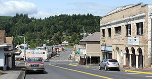 Location in Oregon
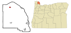
Coordinates: 46°6′11″N 123°12′13″W / 46.10306°N 123.20361°WCoordinates: 46°6′11″N 123°12′13″W / 46.10306°N 123.20361°W Country United States State Oregon County Columbia Incorporated 1891 Government - Mayor Diane Pohl Area - Total 1.2 sq mi (3.1 km2) - Land 1.2 sq mi (3.1 km2) - Water 0 sq mi (0 km2) Elevation 59 ft (17.98 m) Population (2007) - Total 1,710 - Density 1,274.1/sq mi (491.6/km2) Time zone Pacific (UTC-8) - Summer (DST) Pacific (UTC-7) ZIP code 97016 Area code(s) 503 and 971 FIPS code 41-13750[1] GNIS feature ID 1118980[2] Website www.cityofclatskanie.com Clatskanie (
 /ˈklætskɨnaɪ/) is a city in Columbia County, Oregon, United States. It was named for the Clatskanie River, which empties into the Columbia River within the city limits. The population was 1,528 at the 2000 census. The 2007 estimate is 1,710 residents.[3]
Contents
History
According to some reports, the original name of this town when it was platted in 1884 was Bryantville. However, the post office in this location is shown as Clatskanie as early as December, 1871.[who?]
Clatskanie comes from a Native American word, Tlatskani. According to the Clatsop County pioneer Silas B. Smith, Tlatskani was a point in the Nehalem River that was reached from the Columbia River by way of the Youngs River or by way of the Clatskanie River. The native inhabitants, who were not in the habit of naming streams, did not use the word Tlatskani for the streams they would follow in order to get to that point, but the white men who settled here later did apply the name to the streams.[citation needed]
Clatskanie is also the name of a Native American people, whose numbers dwindled from smallpox, intermittent fever, warfare, and intermarriage until they numbered only three people in a 1910 census.[citation needed]
Many of Clatskanie's inhabitants are of Scandinavian heritage, specifically Finnish, Swedish, and Norwegian.[4]
Geography
According to the United States Census Bureau, the city has a total area of 1.2 square miles (3.1 km2), all of it land.
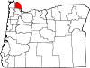
Clatskanie is surrounded by many small unincorporated communities, including Alston, Delena, Clatskanie Heights, Inglis, Kerry, Marshland, Mayger, Quincy, and Woodson.
Demographics
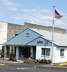 City Hall
As of the census[1] of 2000, there were 1,528 people, 608 households, and 406 families residing in the city. The population density was 1,274.1 people per square mile (491.6/km²). There were 659 housing units at an average density of 549.5 per square mile (212.0/km²). The racial makeup of the city was 93.91% White, 0.07% African American, 1.24% Native American, 0.65% Asian, 0.26% Pacific Islander, 1.05% from other races, and 2.81% from two or more races. Hispanic or Latino of any race were 3.34% of the population. 22.6% were of German, 10.3% Norwegian, 9.4% Finnish, 9.1% Irish, 8.2% English and 6.8% American ancestry according to Census 2000. 94.0% spoke English, 4.1% Spanish and 1.6% Finnish as their first language.
There were 608 households out of which 35.0% had children under the age of 18 living with them, 51.6% were married couples living together, 12.7% had a female householder with no husband present, and 33.1% were non-families. 27.8% of all households were made up of individuals and 15.3% had someone living alone who was 65 years of age or older. The average household size was 2.47 and the average family size was 3.07.
In the city the population was spread out with 29.6% under the age of 18, 7.3% from 18 to 24, 26.0% from 25 to 44, 21.0% from 45 to 64, and 16.0% who were 65 years of age or older. The median age was 36 years. For every 100 females there were 90.5 males. For every 100 females age 18 and over, there were 81.3 males.
The median income for a household in the city was $35,833, and the median income for a family was $48,056. Males had a median income of $41,550 versus $24,286 for females. The per capita income for the city was $16,717. About 11.1% of families and 11.5% of the population were below the poverty line, including 11.4% of those under age 18 and 12.1% of those age 65 or over.
Education
Clatskanie is served by the two public schools of Clatskanie School District, namely the combined Clatskanie Middle/High School, and Clatskanie Elementary School, as well as Piercing Arrow Private School.
Notable people
- Raymond Carver (1938–1988), short story writer and poet
References
- ^ a b "American FactFinder". United States Census Bureau. http://factfinder.census.gov. Retrieved 2008-01-31.
- ^ "US Board on Geographic Names". United States Geological Survey. 2007-10-25. http://geonames.usgs.gov. Retrieved 2008-01-31.
- ^ PSU:Population Research Center
- ^ "The City of Clatskanie". Clatskanie School District. http://www.csd.k12.or.us/?q=node/9.
External links
- City of Clatskanie, Oregon (official website)
Municipalities and communities of Columbia County, Oregon County seat: St. Helens Cities Clatskanie | Columbia City | Prescott | Rainier | St. Helens | Scappoose | Vernonia
Unincorporated
communitiesCategories:- Cities in Oregon
- Populated places in Columbia County, Oregon


Wikimedia Foundation. 2010.