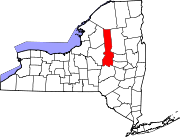
- Mohawk, Herkimer County, New York
-
- Another Mohawk is a town in Montgomery County, New York.
Mohawk, New York — Village — Location within the state of New York Coordinates: 43°0′37″N 75°0′18″W / 43.01028°N 75.005°WCoordinates: 43°0′37″N 75°0′18″W / 43.01028°N 75.005°W Country United States State New York County Herkimer Area – Total 0.9 sq mi (2.4 km2) – Land 0.9 sq mi (2.3 km2) – Water 0.0 sq mi (0.1 km2) Elevation 410 ft (125 m) Population (2000) – Total 2,660 – Density 3,009.8/sq mi (1,162.1/km2) Time zone Eastern (EST) (UTC-5) – Summer (DST) EDT (UTC-4) ZIP code 13407 Area code(s) 315 FIPS code 36-47823 GNIS feature ID 0957470
Mohawk is a village in Herkimer County, New York, United States. The population was 2,660 at the 2000 census. The village was named after the adjacent river.
The Village of Mohawk is at the north border of the Town of German Flatts and adjacent to the Erie Canal. Mohawk is southeast of Utica.
The sports teams of the Mohawk school district call themselves the "Mohicans" although this is somewhat of a misnomer as the Mohican tribe was located near the Hudson River Valley. The Mohawk Nation occupied the Mohawk Valley. Aside from being the incorrect indigenous people, "Mohican" is an incorrect derivative of the word "Mohawk."
Contents
History
Mohawk was originally settled by Palatine Germans after 1722.
In 1725, the Queen of England and Governor Burnet granted Mohawk to the Palatine Germans in what was known as the Burnetsfield Patent.
George Washington was known to stop in Mohawk to have lunch at the Shoemaker Tavern on his way to and from Fort Stanwix in Rome, NY.
Mohawk became known as Bennetts Corners after a hotel stand that was located here in 1826.
In 1838, the village officially became known as Mohawk.
The village was incorporated on April 16, 1844. The first President of the Village, Frederick Bellinger came into office on May 4 of that same year.
The first Mayor of Mohawk was James V. Casey, was elected in 1960.[1] The current mayor is Irene Dibble.
Mohawk is one of only twelve villages in New York still incorporated under a charter, the other villages having incorporated or re-incorporated under the provisions of Village Law.[2]
Geography
Mohawk is located at 43°0′37″N 75°0′18″W / 43.01028°N 75.005°W (43.010194, -75.005022)[3].
According to the United States Census Bureau, the village has a total area of 0.9 square miles (2.4 km²), of which, 0.9 square miles (2.3 km²) of it is land and 0.04 square miles (0.1 km²) of it (3.30%) is water.
The village is on the south bank of the Mohawk River.
Mohawk is east of the Village of Ilion and on the opposite shore of the Mohawk River from the Village of Herkimer.
New York State Route 5S, an east-west highway, lies between the village and the Mohawk River. New York State Route 28 is a north-south highway.
Demographics
As of the census[4] of 2000, there were 2,660 people, 1,146 households, and 708 families residing in the village. The population density was 3,009.8 people per square mile (1,167.1/km²). There were 1,233 housing units at an average density of 1,395.1 per square mile (541.0/km²). The racial makeup of the village was 98.42% White, 0.49% African American, 0.15% Native American, 0.15% Asian, 0.23% from other races, and 0.56% from two or more races. Hispanic or Latino of any race were 1.88% of the population.
There were 1,146 households out of which 27.0% had children under the age of 18 living with them, 47.0% were married couples living together, 10.4% had a female householder with no husband present, and 38.2% were non-families. 30.7% of all households were made up of individuals and 14.8% had someone living alone who was 65 years of age or older. The average household size was 2.29 and the average family size was 2.86.
In the village the population was spread out with 21.7% under the age of 18, 9.4% from 18 to 24, 25.9% from 25 to 44, 24.4% from 45 to 64, and 18.7% who were 65 years of age or older. The median age was 40 years. For every 100 females there were 92.9 males. For every 100 females age 18 and over, there were 85.9 males.
The median income for a household in the village was $32,439, and the median income for a family was $39,185. Males had a median income of $29,915 versus $20,918 for females. The per capita income for the village was $16,469. About 5.5% of families and 8.5% of the population were below the poverty line, including 5.0% of those under age 18 and 6.1% of those age 65 or over.
References
- ^ [1]
- ^ "Local Government Handbook - Village Government: Historical Development" (PDF). New York State Department of State. 2008, 5th edition. pp. PDF page 72. http://www.dos.state.ny.us/lgss/pdfs/Handbook.pdf#page=72. Retrieved 2009-06-26.
- ^ "US Gazetteer files: 2010, 2000, and 1990". United States Census Bureau. 2011-02-12. http://www.census.gov/geo/www/gazetteer/gazette.html. Retrieved 2011-04-23.
- ^ "American FactFinder". United States Census Bureau. http://factfinder.census.gov. Retrieved 2008-01-31.
External links
Municipalities and communities of Herkimer County, New York City Towns Villages Cold Brook | Dolgeville‡ | Frankfort | Herkimer | Ilion | Middleville | Mohawk | Newport | Poland | West Winfield
Hamlets Footnotes ‡This populated place also has portions in an adjacent county or counties
Categories:- Villages in New York
- Utica–Rome metropolitan area
- Populated places in Herkimer County, New York
Wikimedia Foundation. 2010.


