- Dolgeville, New York
-
Dolgeville, New York — Village — Location within the state of New York
 Dolgeville, New York
Coordinates: 43°6′8″N 74°46′20″W / 43.10222°N 74.77222°WCoordinates: 43°6′8″N 74°46′20″W / 43.10222°N 74.77222°W Country United States State New York Counties Herkimer, Fulton Area – Total 1.9 sq mi (4.8 km2) – Land 1.8 sq mi (4.7 km2) – Water 0.0 sq mi (0.1 km2) Elevation 791 ft (241 m) Population (2000) – Total 2,166 – Density 1,182.4/sq mi (456.5/km2) Time zone Eastern (EST) (UTC-5) – Summer (DST) EDT (UTC-4) ZIP code 13329 Area code(s) 315 FIPS code 36-20731 GNIS feature ID 0948550 Dolgeville is a village in Herkimer County, New York, United States. The population was 2,166 at the 2000 census. The village is named after Alfred Dolge (1848–1922), industrialist.
The Village of Dolgeville is mostly in the eastern part of the Town of Manheim, but is partly in the western edge of the Town of Oppenheim in Fulton County, New York. Dolgeville is east of Utica.
Contents
History
The village was founded in 1794 by Samuel Low with the construction of two mills. A grist mill and later a saw mill were built by Captain John Favill on Ransom Creek about 1795. Soon a little settlement sprang up as other settlers moved in; with a blacksmith shop, tannery and school house. Families by the names of Ayers, Spencer, Ransom, Spofford, Lamberson, Brockett and Randall soon followed and settled the adjoining lands which they cleared for farms.
The Village of Dolgeville was incorporated in 1881. The area was at first called "Green's Bridge" in 1805, as a settler named Green built a bridge over East creek. In 1826 the area received its first post office, with Zephi Brockett as postmaster, and the area was renamed "Brockett’s Bridge" in his honor. In 1887 the citizens unanimously petitioned the authorities at Washington to change the name of the place from Brockett’s Bridge to Dolgeville.[1]
The village changed it name to Dolgeville because of the economic growth promoted by Alfred Dolge (1848–1922), a pioneering and benevolent industrialist. In addition to factories, Dolge built a railroad, laid out the village, built two schools, installed an electric system, a water system, sewage, a fire department, a free library, a concert hall, a gymnasium, public parks, a newspaper and pioneered in a pension and profit sharing system for employees.[1]
Dolgeville encountered an economic downturn in 1999 when the Daniel Green shoe company shut down their Dolgeville factory, which was the largest source of employment in the village.
Dolgeville is currently experiencing an economic recovery with the opening of a crafts, antiques, and furniture mall, Dolgeville Mill, in the old Daniel Green factory, which in turn has encouraged some other businesses to open in Dolgeville.
The village still has a number of factories, including Rawlings, which makes a large percentage of the baseball bats used by Major League Baseball, Adirondack brand bats, as well as other wood products; North Hudson Woodcraft Corp. which had manufactured piano parts for Steinway since the 1800s until about 2005, now manufactures other wood products such as kitchen cabinets and caskets; Tricot, which manufactures textile products; Tumbleforms and Bergeron By Design, which both manufacture therapy products.
Lyndon Lyon greenhouse is world famous for African Violets and orchids.
Geography
Dolgeville is located at 43°06′08″N 74°46′20″W / 43.102233°N 74.772294°W (43.102233, -74.772294).[2]
According to the United States Census Bureau, the village has a total area of 1.9 square miles (4.8 km2), of which, 1.8 square miles (4.7 km2) of it is land and 0.04 square miles (0.1 km2) of it (1.60%) is water.
Festivals include the Violet Festival in June, Oktoberfest in autumn, Covered Bridge Days in nearby Salisbury, celebrating a very old and well-preserved specimen of one of only 12 or 13 covered bridges left in New York State.
The village is divided by the East Canada Creek.
New York State Route 29 and New York State Route 169 intersect in Dolgeville. The village is also served by County Roads 83 and 99.
Demographics
As of the census[3] of 2000, there were 2,166 people, 915 households, and 592 families residing in the village. The population density was 1,182.4 people per square mile (457.0/km2). There were 1,018 housing units at an average density of 555.7 per square mile (214.8/km2). The racial makeup of the village was 97.41% White, 0.23% African American, 0.69% Native American, 0.42% Asian, 0.05% Pacific Islander, 0.09% from other races, and 1.11% from two or more races. Hispanic or Latino of any race were 0.97% of the population.
There were 915 households out of which 29.8% had children under the age of 18 living with them, 46.7% were married couples living together, 12.8% had a female householder with no husband present, and 35.2% were non-families. 31.5% of all households were made up of individuals and 17.6% had someone living alone who was 65 years of age or older. The average household size was 2.35 and the average family size was 2.91.
In the village the population was spread out with 24.3% under the age of 18, 7.8% from 18 to 24, 23.9% from 25 to 44, 25.8% from 45 to 64, and 18.3% who were 65 years of age or older. The median age was 41 years. For every 100 females there were 87.4 males. For every 100 females age 18 and over, there were 85.1 males.
The median income for a household in the village was $30,863, and the median income for a family was $38,646. Males had a median income of $29,667 versus $17,500 for females. The per capita income for the village was $14,787. About 7.4% of families and 10.9% of the population were below the poverty line, including 12.3% of those under age 18 and 10.9% of those age 65 or over.
References
- ^ a b Doris Manley and Eleanor Franz (undated). "National Register of Historic Places Registration: Dolge Company Factory Complex". New York State Office of Parks, Recreation and Historic Preservation. http://www.oprhp.state.ny.us/hpimaging/hp_view.asp?GroupView=2717. Retrieved 2010-07-21.
- ^ "US Gazetteer files: 2010, 2000, and 1990". United States Census Bureau. 2011-02-12. http://www.census.gov/geo/www/gazetteer/gazette.html. Retrieved 2011-04-23.
- ^ "American FactFinder". United States Census Bureau. http://factfinder.census.gov. Retrieved 2008-01-31.
External links
- Village of Dolgeville, NY
- Dolgeville-Manheim Public Library
- Dolgeville Christian Fellowship, a local church website
- Keekaroo, a local manufacture website
- Adaptivemall, a local manufacture website
Municipalities and communities of Fulton County, New York Cities 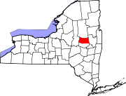
Towns Bleecker | Broadalbin | Caroga | Ephratah | Johnstown | Mayfield | Northampton | Oppenheim | Perth | Stratford
Villages Broadalbin | Dolgeville‡ | Mayfield | Northville
Footnotes ‡This populated place also has portions in an adjacent county or counties
Municipalities and communities of Herkimer County, New York City 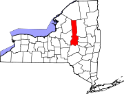
Towns Villages Cold Brook | Dolgeville‡ | Frankfort | Herkimer | Ilion | Middleville | Mohawk | Newport | Poland | West Winfield
Hamlets Footnotes ‡This populated place also has portions in an adjacent county or counties
Categories:- Villages in New York
- Utica–Rome metropolitan area
- Populated places in Herkimer County, New York
- Populated places in Fulton County, New York


Wikimedia Foundation. 2010.