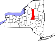
- Danube, New York
-
Danube, New York — Town — Location within the state of New York Coordinates: 42°59′17″N 74°48′9″W / 42.98806°N 74.8025°WCoordinates: 42°59′17″N 74°48′9″W / 42.98806°N 74.8025°W Country United States State New York County Herkimer Government – Type Town Council – Town Supervisor Charles M. Welden (R) – Town Council Members' ListArea – Total 29.6 sq mi (76.8 km2) – Land 29.4 sq mi (76.1 km2) – Water 0.3 sq mi (0.7 km2) Elevation 443 ft (135 m) Population (2000) – Total 1,098 – Density 37.4/sq mi (14.4/km2) Time zone Eastern (EST) (UTC-5) – Summer (DST) EDT (UTC-4) FIPS code 36-19686 GNIS feature ID 0978885 Danube is a town in Herkimer County, New York, United States. The population was 1,098 at the 2000 census. Early Palatine German immigrants in the eighteenth century named the town after the Danube River in Europe.
The Town of Danube is in southeastern Herkimer County, southeast of the City of Little Falls.
Contents
History
The town was first settled around 1730 on the territories of Lindsey's (1730) and Van Horne's (1731) patents. The town was within the territory of the Mohawk tribe, who in coordination with colonial government had constructed one or more fortified settlements. The Town of Danube was formed in 1817 from the Town of Minden (in Montgomery County). Part of Danube was taken off in 1828 to form the Town of Stark.
Notable residents
- King Hendrick[disambiguation needed
 ], Mohawk leader, lived in Indian Castle.
 - Nicholas Herkimer- New York state militia general, who died due to wounds after the Battle of Oriskany.
- John Herkimer, his nephew, judge, soldier & New York State Congressman
- William Sickles, Medal of Honor, Civil War
Geography
According to the United States Census Bureau, the town has a total area of 29.6 square miles (77 km2), of which, 29.4 square miles (76 km2) of it is land and 0.3 square miles (0.78 km2) of it (0.91%) is water.
The east town line is the border of Montgomery County. The north town line is marked by the Mohawk River and the Erie Canal.
The New York State Thruway (Interstate 90) passes across the north part of the town. New York State Route 5S is an east-west highway that parallels the Thruway. New York State Route 169 intersects NY-5S and the Thruway in the northwest part of Danube.
Demographics
As of the census[1] of 2000, there were 1,098 people, 398 households, and 280 families residing in the town. The population density was 37.4 people per square mile (14.4/km²). There were 442 housing units at an average density of 15.0 per square mile (5.8/km²). The racial makeup of the town was 96.90% White, 0.82% African American, 0.36% Native American, 0.91% Asian, 0.09% from other races, and 0.91% from two or more races. Hispanic or Latino of any race were 0.91% of the population.
There were 398 households out of which 35.9% had children under the age of 18 living with them, 52.8% were married couples living together, 9.3% had a female householder with no husband present, and 29.6% were non-families. 23.6% of all households were made up of individuals and 9.8% had someone living alone who was 65 years of age or older. The average household size was 2.76 and the average family size was 3.22.
In the town the population was spread out with 31.1% under the age of 18, 6.6% from 18 to 24, 28.8% from 25 to 44, 22.8% from 45 to 64, and 10.8% who were 65 years of age or older. The median age was 35 years. For every 100 females there were 111.6 males. For every 100 females age 18 and over, there were 112.0 males.
The median income for a household in the town was $31,815, and the median income for a family was $32,500. Males had a median income of $28,661 versus $20,000 for females. The per capita income for the town was $13,572. About 15.5% of families and 18.4% of the population were below the poverty line, including 27.8% of those under age 18 and 6.2% of those age 65 or over.
Communities
- Danube – A location in the north part of the town on NY-5S.
- Davys Corners – A location in the northeast corner of the town.
- Fink Basin – A hamlet near the Mohawk River by NY-169
- Herkimer Home State Historic Site – The home of Nicholas Herkimer is near Fink Basin and the Mohawk River.
- Indian Castle – A hamlet in the northeast part of the town, east of Danube village.
- Newville-- A hamlet in the southwest part of the town on County Road 32.
References
- ^ "American FactFinder". United States Census Bureau. http://factfinder.census.gov. Retrieved 2008-01-31.
External links
- Danube official website
- Town government website
- Early history of Danube, NY
- Historical information: Danube, NY
- Danube Town Court
Municipalities and communities of Herkimer County, New York City Towns Villages Cold Brook | Dolgeville‡ | Frankfort | Herkimer | Ilion | Middleville | Mohawk | Newport | Poland | West Winfield
Hamlets Footnotes ‡This populated place also has portions in an adjacent county or counties
Categories:- Towns in New York
- Utica–Rome metropolitan area
- Populated places in Herkimer County, New York
- King Hendrick[disambiguation needed
Wikimedia Foundation. 2010.


