- Denbury
-
Coordinates: 50°30′28″N 3°39′38″W / 50.50775°N 3.66051°W
Denbury
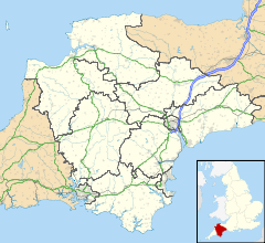
 Denbury shown within Devon
OS grid reference SX823688 Parish Denbury and Torbryan District Teignbridge Shire county Devon Region South West Country England Sovereign state United Kingdom Post town NEWTON ABBOT Postcode district TQ12 Dialling code 01803 Police Devon and Cornwall Fire Devon and Somerset Ambulance South Western EU Parliament South West England UK Parliament Teignbridge List of places: UK • England • Devon Denbury is a village in Teignbridge district of Devon, England. The village is situated between Totnes and Newton Abbot, approximately ten miles from Torquay.
Denbury Hill is an Iron Age Hill fort which is located to the south west of the village. The area has a long history of human habitation, with Denbury Manor being owned by Ealdred, Archbishop of York, before the Norman conquest of England in 1066. The Parish Church of St Mary the Virgin in the village dates from 12th century.[1]
The United States Army built a camp and shooting range in the village in the run up to the invasion of Europe in 1944. The site was taken over by the Royal Corps of Signals junior training Regiment, until the 1970s, when Channings Wood Prison was constructed on most of the site.[2] Today, Channings Wood is a Category C prison for men from all over South Western England, and is the biggest employer in Denbury. The other part of the former military base is now the Denbury Range, home of the Torbay Fullbore Club.[3]
The village today comprises 300 households including farms in the surrounding area. The village forms part of the Denbury and Torbryan civil parish.
References
External links
 Media related to Denbury at Wikimedia CommonsCategories:
- Villages in Devon
- Devon geography stubs
Wikimedia Foundation. 2010.

