- Mantorville, Minnesota
-
Mantorville, Minnesota — City — Dodge County Courthouse in Mantorville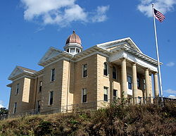 Location of Mantorville, Minnesota
Coordinates: 44°4′2″N 92°45′27″W / 44.06722°N 92.7575°WCoordinates: 44°4′2″N 92°45′27″W / 44.06722°N 92.7575°W Country United States State Minnesota County Dodge Incorporated 1854 Area – Total 1.4 sq mi (3.7 km2) – Land 1.4 sq mi (3.7 km2) – Water 0.0 sq mi (0.0 km2) Elevation 1,178 ft (359 m) Population (2010)[1] – Total 1,197 – Density 741.3/sq mi (286.2/km2) Time zone Central (CST) (UTC-6) – Summer (DST) CDT (UTC-5) ZIP code 55955 Area code(s) 507 FIPS code 27-39986[2] GNIS feature ID 0647454[3] Mantorville is a city in Dodge County, Minnesota, United States. The population was 1,197 at the 2010 census.[1] It is the county seat of Dodge County[4]. Founded in 1854, the city is one of the oldest in Minnesota. It is known as the source of Mantorville limestone, which found its way into buildings across the United States. Mantorville shares a school system with nearby Kasson, Minnesota (the "K-M Komets"). The K-M school system is a member of the Zumbro Education school district (ZED).
Minnesota State Highway 57 serves as a main arterial route in the city.
The limestone quarried in the area was soft and easily carved when first extracted, but became harder as it endured the elements, making it a long-lasting building material. The historic Hubbell House used the stone in 1856, and it was likewise used in 1865 for the Dodge County Courthouse, designed by E. Townsend Mix and now the oldest working courthouse in Minnesota.
Mantorville is named for Peter and Riley Mantor, brothers who came to the settlement in 1853. The city was added as a district to the National Register of Historic Places in 1974.
Contents
Geography
Mantorville is located along the South Branch of the Middle Fork of the Zumbro River, west of Rochester, Minnesota. According to the United States Census Bureau, the city has a total area of 1.4 square miles (3.6 km2), all of it land.
Demographics
Historical populations Census Pop. %± 1870 622 — 1880 477 −23.3% 1890 460 −3.6% 1900 602 30.9% 1910 410 −31.9% 1920 381 −7.1% 1930 387 1.6% 1940 486 25.6% 1950 477 −1.9% 1960 498 4.4% 1970 479 −3.8% 1980 705 47.2% 1990 874 24.0% 2000 1,054 20.6% 2010 1,197 13.6% U.S. Decennial Census As of the census[2] of 2000, there were 1,054 people, 371 households, and 286 families residing in the city. The population density was 741.3 people per square mile (286.6/km²). There were 378 housing units at an average density of 265.8 per square mile (102.8/km²). The racial makeup of the city was 98.48% White, 0.57% Native American, 0.19% Asian, 0.09% from other races, and 0.66% from two or more races. Hispanic or Latino of any race were 0.76% of the population.
There were 371 households out of which 45.3% had children under the age of 18 living with them, 68.5% were married couples living together, 5.7% had a female householder with no husband present, and 22.9% were non-families. 18.6% of all households were made up of individuals and 8.6% had someone living alone who was 65 years of age or older. The average household size was 2.84 and the average family size was 3.26.
In the city the population was spread out with 32.3% under the age of 18, 5.6% from 18 to 24, 34.5% from 25 to 44, 19.9% from 45 to 64, and 7.7% who were 65 years of age or older. The median age was 33 years. For every 100 females there were 99.6 males. For every 100 females age 18 and over, there were 99.4 males.
The median income for a household in the city was $55,735, and the median income for a family was $62,625. Males had a median income of $39,167 versus $29,464 for females. The per capita income for the city was $20,853. About 6.2% of families and 6.4% of the population were below the poverty line, including 6.6% of those under age 18 and 15.3% of those age 65 or over.
Notable people
- Edwin Osgood Grover, educator and publisher
References
- ^ a b "2010 Census Redistricting Data (Public Law 94-171) Summary File". American FactFinder. United States Census Bureau. http://factfinder2.census.gov/faces/tableservices/jsf/pages/productview.xhtml?pid=DEC_10_PL_GCTPL2.ST13&prodType=table. Retrieved 27 April 2011.
- ^ a b "American FactFinder". United States Census Bureau. http://factfinder.census.gov. Retrieved 2008-01-31.
- ^ "US Board on Geographic Names". United States Geological Survey. 2007-10-25. http://geonames.usgs.gov. Retrieved 2008-01-31.
- ^ "Find a County". National Association of Counties. http://www.naco.org/Counties/Pages/FindACounty.aspx. Retrieved 2011-06-07.
External links
- Mantorville, Minnesota
- Mantorville Walking Tour, with profiles of historic buildings
Municipalities and communities of Dodge County, Minnesota Cities Blooming Prairie‡ | Claremont | Dodge Center | Hayfield | Kasson | Mantorville | West Concord

Townships Unincorporated
communitiesBerne
Ghost town Rice Lake‡
Footnotes ‡This populated place also has portions in an adjacent county or counties
Over 100,000 Incorporated
Places(over 5,000) (under 5,000) Byron · Dodge Center · Plainview · Elgin · Millville · Wabasha · Eyota · Pine Island‡ · Blooming Prairie‡ · Dover · Chatfield‡ · Mazeppa · Minneiska‡ · Hammond · Kellogg · Zumbro Falls · Bellechester‡ · Oronoco · West Concord · ClaremontCounties ‡ indicates that it is partially in the metropolitan area.Categories:- Cities in Minnesota
- Populated places in Dodge County, Minnesota
- National Register of Historic Places in Minnesota
- Zumbro River
- County seats in Minnesota
- Rochester, Minnesota metropolitan area


Wikimedia Foundation. 2010.