- Climate of Salt Lake City
-
Salt Lake City Climate chart (explanation) J F M A M J J A S O N D 1.437211.343261.95333261392.171470.882560.791630.889621.378521.664411.449301.23822Average max. and min. temperatures in °F Precipitation totals in inches Source: NOAA[1] Metric conversion J F M A M J J A S O N D 353-6346-449121511645321820281318331719321734251140185369-1313-5Average max. and min. temperatures in °C Precipitation totals in mm The climate of Salt Lake City is widely variable. The city lies in a semi-arid region in the Salt Lake Valley, surrounded by mountains and the Great Salt Lake, and receives little precipitation. Under the Koppen climate classification, Salt Lake City has a semi-arid climate (Köppen climate classification BSk). The city has four distinct seasons, with a cold, snowy winter, a hot, dry summer, and comfortable, relatively wet transition periods. The Pacific Ocean is the primary influence on the weather, contributing storms from about October to May, with spring being the wettest season. Snow falls frequently during the winter, contributed largely by the lake-effect from the Great Salt Lake. The only source of precipitation in the summer is monsoon moisture moving north from the Gulf of California. Summers are hot, frequently reaching above 100°F (38°C), while winters are cold and snowy. However, winters are warmer than one would expect at this elevation and latitude, due to the Rocky Mountains to the east and north that usually block powerful polar highs from affecting the state during the winter. Temperatures rarely fall below 0°F (-18°C), but frequently stay below freezing. Temperature inversions during winter can lead to thick overnight fog and daytime haze in the valley as cool air, moisture, and pollutants are trapped in the valley by surrounding mountains.
Contents
Temperatures
Winter temperatures are not as extreme as one would expect, given the elevation 4,300 feet (1,310 m) and latitude (40°45'N) of the city. The Rocky Mountains to the east and northeast of the state block most cold waves from polar highs positioned in the Great Plains from reaching the city. The frigidly cold air that does affect the city must come directly from the north or north-northwest from western Canada through fewer and lower intervening mountains. Temperatures seldom fall below 0 °F (−17.8 °C); Salt Lake City has experienced sub-zero temperatures during only 4 storm cycles in the last 10 years. However, the average sub-zero days in a year is 2.3.[1] Salt Lake City averages 26 days with high temperatures at or below freezing.[2] In winter, warm air from the Desert Southwest is usually only drawn up to the city in advance of a cold front arriving from the northwest.
January is the coldest month with an average temperature of 29.2 °F (−1.6 °C). Salt Lake City's record low maximum temperature is 2 °F (−16.7 °C), set on December 22, 1990, during an extended period of frigid Arctic air, and its overall record low temperature is −30 °F (−34.4 °C), set on February 9, 1933 during a historic cold air surge from the north.[2] During spring, temperatures warm steadily and rapidly. Wintry weather is usually last experienced by early-to-mid March. Summery weather first arrives in early to mid May; the earliest 90 °F (32.2 °C) temperature on record was on May 2. Major cold fronts typically stop arriving in late May or early June.
Summer temperatures are hot, although are moderated somewhat by the cool breezes from the Great Salt Lake and by the city's elevation. The lack of cold fronts in summer allows the temperatures to become consistently hot due to powerful, long-lasting high pressure . Occasional thunderstorms give almost the only relief in temperatures. In an average year one can expect 15 days hotter than 100 °F (37.8 °C), 23 days greater than 95 °F (35.0 °C), and 56 days greater than 90 °F (32.2 °C)[3]. However, such days are marked with low humidity, making these high temperatures comparatively comfortable. The low humidity and the altitude create ideal conditions for radiational cooling, and hence, large swings in temperature. Summer nights are rather cool; the record low even in July is 40 °F (4.4 °C).[2] July is the warmest month, with an average temperature of 77.0 °F (25.0 °C). Salt Lake City's record high minimum temperature is 80 °F (26.7 °C), set on July 16, 2003, during the hottest month on record, and its record high temperature is 107 °F (42 °C), first set on July 26, 1960 and again on July 13, 2002 (although the temperature in 2002 was slightly higher).[3] The last summer-like weather is typically experienced in mid-September; the latest 90°F (32°C) temperature was recorded on September 30. Temperatures cool down rapidly in fall. The first major cold fronts typically arrive anytime from mid-September to early October. The first winter-like weather is usually experienced in early-to-mid November.
Salt Lake City's average yearly temperature is 52.1 °F (11.2 °C),[1] and the freeze-free period lasts an average of 167 days, from April 30 to October 15, although it has lasted anywhere from 124 to 236 days.[4] Freezing temperatures have occurred as early as September 13 (in 1928), and as late as May 28 (in 1954).
Precipitation
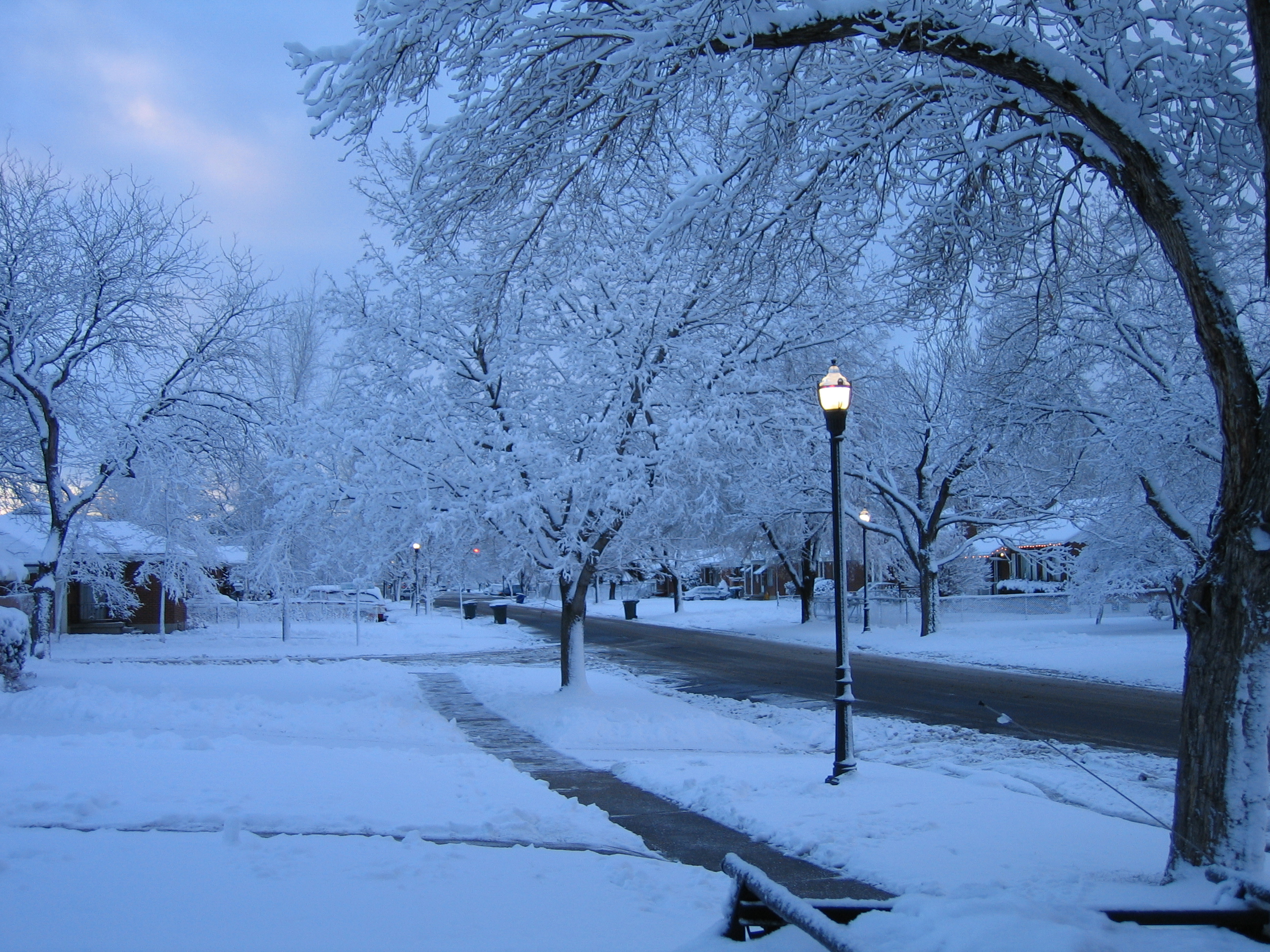
 Spring storms are common in Salt Lake City.
Both precipitation and humidity are highest from March through May and lowest from June through mid-September. Major sources of precipitation are winter snow storms originating in the Gulf of Alaska, late winter and spring rains from the Pineapple Express created in Hawaiian waters, and summer monsoons from the Gulf of California. The airport averages 16.5 inches (419 mm) of precipitation per year, with bench areas receiving up to 20 inches (508 mm), mainly due to increased snowfall. May is the wettest month, averaging 2.09 inches (53.1 mm) of precipitation. Average year-round humidity is 55%.
The summer monsoon rising from Mexico and Arizona passes through the region beginning in mid-July and continuing into September, bringing intense but short-lived thunderstorm activity. Tornadoes have been known to occur during this time period, the most notable recent example being in 1999 when an F2 tornado struck downtown Salt Lake City, causing extensive damage and resulting in one death. Many of these thunderstorms consist of dry lightning, which occurs when humidity is too low to support rainfall and the rain evaporates before reaching the ground. This is the main cause of wildfires in Utah during summer. Smoke from such fires in nearby areas sometimes make their way into the valley. Despite the intensity of the thunderstorms, the low humidity, short duration, and isolationism of the thunderstorms all play a part in making this the driest season. July is the driest month, with only 0.72 in (18.3 mm) of precipitation on average. In late fall, the Pacific Ocean usually begins to kick in again, and starting in late September precipitation begins to increase. During late summer and fall, remnants of tropical cyclones from the East Pacific occasionally reach Utah, resulting in heavy tropical rains. Weather events such as hail, freezing rain, and sleet are uncommon in Salt Lake City. When they do occur, they are of short duration and rarely accumulate. The record precipitation for a single month occurred in September 1982, with 7.04 inches (179 mm), largely due to the remnants of Hurricane Olivia. The record 24 hour precipitation occurred from April 22-23, 1957, when 2.41 inches (61.2 mm) fell.
The first snowfall of the season is usually recorded in October, although significant snowfall usually does not occur until mid-to-late November. However, snow has been recorded in every month of the year in the mountains. Snow fell in the valley as early as September 17 (in 1965). January averages the most snowfall of any month, with 13.6 inches (34.5 cm). Snowfall is common through mid-March, but the last snowfall of the season usually occurs in early or mid-April, although measurable snow has been recorded on the valley floor as late as May 18 (in 1977). However, significant snow can fall in March and in rare cases even April. Measurable snow falls on average from November 6 through April 18.
The airport also averages 61 inches (155 cm) of snow in a year, which is more than most Great Plains and Mid-Atlantic locations. However, bench locations near the mountains receive substantially more, reaching 80 to 100 in (200 to 255 cm) annually. The four ski resorts located in Big and Little Cottonwood each average more than 500" of snow per year. These high snowfall totals can be credited to the lake effect, in which snow storms passing over the Great Salt Lake are amplified by the warm waters of the lake. The lake effect is usually strongest from mid-fall through mid-winter, when lake waters are warmer and land temperatures are cold enough to support snow.
Blizzards are very rare in the Salt Lake City valley due to a rarity of extreme winds. Although average snowfall is relatively high, large snowstorms of more than about 12 inches (30 cm) are rare in the valley. In addition, average winter temperatures in the city are usually not cold enough to support snow cover all winter long. The maximum snow depth recorded in the city was 26 in (66 cm) on January 11, 1993. January 1993 was the snowiest month on record, with 50.3 inches (128 cm). The record 24 hour snowfall occurred from February 24-25, 1998, when 18.9 in (48 cm) fell, while the record single storm snowfall occurred from January 6-10, 1993, with 23.3 inches (59 cm). The snowiest season on record was 1951-1952, when 117.3 inches (298 cm) fell, while the least snowy winter on record was 1939-1940, with 18.5 inches (47.0 cm).
The airport averages around 37 and 97 days of snow and precipitation, respectively, each year.[1] Daily sunshine hours range from a low of 3.6 in December to a high of 12.3 in July,[4] all for a bountiful total of nearly 3030 hours per year.
Jan Feb Mar Apr May Jun Jul Aug Sep Oct Nov Dec Record Precipitation in. 3.23 4.89 3.97 4.90 4.76 3.84 2.57 3.66 7.04 3.91 3.34 4.37 Average Precipitation in. 1.37 1.33 1.91 2.02 2.09 0.77 0.72 0.76 1.33 1.57 1.40 1.23 Average Snowfall in. 13.6 9.9 9.1 4.9 0.6 0.0 0.0 0.0 0.1 1.3 7.0 12.0 Record Snowfall in. 50.3 32.1 41.9 26.4 7.5 0.0 0.0 0.0 4.0 20.4 33.3 35.2 Data is for Salt Lake International Airport 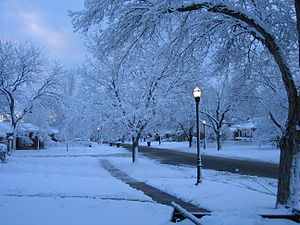 Tree-lined streets
Other weather events
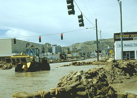
 Flood of City Creek, 1983.
The phenomena El Niño and La Niña also affect precipitation along the Great Basin, bringing occasional cycles of drought and flooding. The largest recent flood in Salt Lake City occurred in 1983. Triggered by a powerful El Niño, an exceptionally large snowpack caused flooding and massive damage. City Creek burst from its underground diversion and flooded the city. Some streets, such as State Street and 1300 South, were diverted into make-shift rivers to accommodate the overflowing creek. Some flooding also occurred in 1987, when the Great Salt Lake reached its all-time maximum water level.
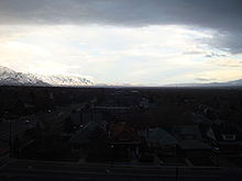
One of the most significant weather events in Salt Lake City occurs in mid-winter, when temperature inversions sometimes form, resulting in cold and extremely foggy, hazy weather in the city while the surrounding mountains enjoy warmer temperatures and sunshine. Temperature inversions are extremely unhealthy and can occur weeks at a time, and are most pronounced in the heart of winter, although may occur in other seasons to a lesser extent. Humidity is only high enough and temperatures cold enough for fog to occur in the heart of winter, although haze and smog can be found year-round. Inversions occur when strong areas of high pressure park themselves over the Great Basin. It usually takes a cold front to force out or break down the high pressure. Consequently, inversions are very rare in spring and fall, when the atmosphere usually takes on a progressive pattern, with fronts moving through frequently.
Tornadoes are also relatively uncommon. However, there has been at least one damaging tornado in the city. The Salt Lake City Tornado of August 11, 1999, which killed one person and injured 60, resulted in only the second ever fatality from a tornado in Utah, and caused about $500 million in damage. As a result of extended drought patterns, Salt Lake City constructed several reservoirs to hold excess water during flood periods and provide water during drought conditions. Additionally, artesian wells and water siphoned from Utah Lake miles to the south act as alternate water sources for the city. [5]
Recent weather events
Utah was in a consistent drought from late 1998 through 2004, although experts warn that the drought-breaking conditions experienced in 2004 and 2005 could actually just be a break in a more extended drought pattern. July 2003 set the record for the warmest month ever in Salt Lake City. 2003 overall was the second warmest year on record, and recorded the second-warmest January, August, and October on record, but with the warmest month ever (July). January 2003 saw a record high January temperature of 63°F (17°C) and record low January snowfall (a trace). That winter was the sixth warmest and third least snowy on record. May 2003 also set a record high May temperature of 99°F (37°C) on two consecutive days. July 2002 also saw a record-tying high temperature of 107°F (41°C), while July 2003 saw a record high minimum temperature (80 °F; 27°C) and a record streak of 100 degree weather (July contributed 10 of that summer's 24 days over 100 degrees).
In late December 2003, a large snowstorm dumped more than 18 inches (460 mm) of snow across the valley, with up to 40 inches (1,000 mm) in high bench areas and up to 100 inches (2,500 mm) in the Wasatch Range. From December 25-29, the official station saw 21.9 inches (56 cm). This snowstorm also caused widespread power outages. Accompanied by subsequent snowstorms and a very cold January and February, snow from this storm remained on the ground for the remainder of the winter. From January 3-26, Salt Lake City spent a record amount of time below freezing. January and February were both very cold, but this was followed by the fourth-warmest March on record, which also saw a record-tying March high.
Before 2005, 1998 was the last year to see above-average precipitation. Near record-setting snowpack in the mountains during the 2004 to 2005 season, as well as heavy spring rains, ended the drought nearly state-wide. Heavy winter and spring rains caused flooding throughout the state. In late January, heavy rains overflowed the Santa Clara River in Washington County in the southwest corner of the state, destroying several homes in Ivins, Santa Clara, and Saint George, and essentially cutting off the small town of Gunlock. Heavy spring rains in late April caused widespread but minor flooding in northern Utah.
Heat returned in the summer of 2006, with July 2006 becoming the second-hottest July on record. Summer 2006 (June-August) closed as the 4th-hottest on record, tempered only by a near-average August. January 2007 became the coldest month since December 1990, and the coldest January since 1978. April 29, 2007, saw a record April high temperature of 89°F. Snow levels in the ski resorts were near record lows. It became one of the driest springs on record in Salt Lake City.
Heat returned again in the summer of 2007, with July 2007 breaking the aforementioned July 2003 record. July 2007 also set the record for the highest average monthly minimum temperature. December 2007 became the third-wettest on record. Snowfall was also abnormally high throughout the winter of 2007-2008 as snow came at an unusually frequent pace. Snow totals ended only slightly under the totals of 2003-2004 without a major snowstorm to boost the totals. Spring 2008 was once again dry but was very cool. Heat returned that summer once again and July 2008 became the fifth-warmest month on record.
Notes
- ^ Cite error: Invalid
<ref>tag; no text was provided for refs namedNCDC; see Help:Cite errors/Cite error references no text - ^ Cite error: Invalid
<ref>tag; no text was provided for refs namedRecMin; see Help:Cite errors/Cite error references no text - ^ Cite error: Invalid
<ref>tag; no text was provided for refs namedRecMax; see Help:Cite errors/Cite error references no text - ^ Cite error: Invalid
<ref>tag; no text was provided for refs namedHKO; see Help:Cite errors/Cite error references no text
References
- Climate charts, retrieved November 2004
External links
Salt Lake City Information Buildings and sites · Climate · Education · Notable citizens · Geography · History · Libraries · Mayors · Media · TransportationNeighborhoods 9th and 9th · The Avenues · Capitol Hill · Central City · Downtown · Foothill · Federal Heights · Glendale · Poplar Grove · Rose Park · Sugar HouseSports Teams Entertainment The DepotCategories:- Salt Lake City, Utah
- Climate by city
- Climate of Utah
- ^ Cite error: Invalid
Wikimedia Foundation. 2010.