- BMT Myrtle Avenue Line
-
For the bus, formerly streetcar, line along Myrtle Avenue in Brooklyn, see Myrtle Avenue Line (surface). For the surface line in Queens, see Richmond Hill Line.
BMT Myrtle Avenue Line 
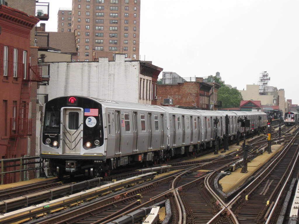
The M train serves the entire BMT Myrtle Avenue Line at all timesOverview Type Rapid transit System New York City Subway Termini Metropolitan Avenue
Central AvenueStations 7 Operation Opened 1889-1915 Owner City of New York Operator(s) New York City Transit Authority Character Street level(Metropolitan Avenue only)
ElevatedTechnical No. of tracks 2 Track gauge 4 ft 8 1⁄2 in (1,435 mm) Electrification 600V DC third rail BMT Myrtle Avenue Line Legend

Middle Village – Metropolitan Avenue 

Fresh Pond Yard 

Fresh Pond Road Forest Avenue Seneca Avenue 


Myrtle–Wyckoff Avenues BMT Canarsie Line Knickerbocker Avenue Central Avenue 


Myrtle Avenue BMT Jamaica Line 
Sumner Avenue Tompkins Avenue 
IND Crosstown Line Nostrand Avenue Franklin Avenue Grand Avenue 

BMT Lexington Avenue Line Washington Avenue Vanderbilt Avenue Navy Street BMT Fifth Avenue Line BMT Brighton Line BMT Fourth Avenue Line 
Bridge–Jay Streets IND Fulton Street Line Adams Street BMT Fulton Street Line 
Sands Street 
Brooklyn Bridge 
Park Row The Myrtle Avenue Line, also called the Myrtle Avenue Elevated[1], is a fully elevated line of the New York City Subway as part of the BMT division. The extant line is the final remnant of one of the original Brooklyn elevated railroads. The remnant line operates as a spur branch from the Jamaica Line to Bushwick, Ridgewood and Middle Village, terminating at its original Eastern terminal across the street from Lutheran Cemetery. Until 1969, the line continued west into Downtown Brooklyn and until 1944, over the Brooklyn Bridge to a terminal at Park Row in Manhattan.
Contents
Extent and service
The Myrtle Avenue Line is currently served by the M service. The line begins at Middle Village – Metropolitan Avenue in Queens. It heads southwest along a private right-of-way, eventually joining an elevated structure above Palmetto Street and Myrtle Avenue. Just before reaching Broadway (on which the BMT Jamaica Line operates), the line curves to the left and merges into the Jamaica Line tracks just east of Myrtle Avenue. The upper level of the station (called "Broadway") opened in 1889 and closed on October 4, 1969, still exists. During late nights and weekends, the M shuttle service terminates here. During this period, the M operates as OPTO (one person train operation) with only four car trains. Like the other lines in the BMT Eastern Division, the station platforms on the Myrtle Avenue Line can only hold 480 feet long trains (eight 60 feet cars), 120 feet shorter than the standard 600 feet length (eight 75 feet cars or ten 60 feet cars) of other "B" Division stations.
Background
The first section of the line ran over Myrtle Avenue from Johnson and Adams Streets to a junction with what was then known as the Main Line at Grand Avenue and was opened on April 10, 1888 by the Union Elevated Railroad. Trains continued along Grand Avenue and Lexington Avenue to Broadway, where the line joined the Broadway Elevated, and then along Broadway to East New York. On September 1, 1888, the line was extended westward along Adams Street and Sands Street, to a terminal at Washington Street for the Brooklyn Bridge. On April 27, 1889, the line was extended east along Myrtle Avenue to Broadway.
The west end of the line was extended north along Adams Street to an elevated station over Sands Street and High Street in 1896. The connection to the Brooklyn Bridge tracks opened on June 18, 1898, along a private right-of-way halfway between Concord Street and Cathedral Place. The first trains to use it came from the Fifth Avenue Elevated (using the Myrtle Avenue El west of Hudson Avenue).
The line was later extended east to Wyckoff Avenue (at the Brooklyn/Queens border). In 1906 the el was connected via a ramp to the Lutheran Cemetery Line, a former steam dummy line to Metropolitan Avenue that had opened on September 3, 1881. That section was elevated as part of the Dual Contracts on February 22, 1915.
On July 29, 1914, the connection to the Broadway (Brooklyn) Line was opened, allowing Myrtle Avenue Line trains to operate via the Williamsburg Bridge. This service became BMT 10 in 1924, and the original Myrtle Avenue Line service to Park Row became BMT 11, later referred to as M and MJ.
As part of the Dual Contracts rebuilding of the Myrtle Avenue El, a third track was installed north of Myrtle Avenue. This track started from a point south of Central Avenue through Myrtle – Wyckoff Avenues to a bumper just south of Seneca Avenue. The only switches were at the southern end so the center track could only be used for layups. It was never used in revenue service and removed sometime after World War II.
On March 5, 1944, the line west of Bridge–Jay Streets was closed coincident with the end of elevated service over the Brooklyn Bridge. The rest of the line from Broadway to Jay Street closed on October 4, 1969 and demolished soon after, ending the MJ service.
Chaining information
- The entire line is chained BMT M. This has no relation to the fact that the M service operates on the line, though both letters may have been chosen because 'Myrtle' begins with 'M'.
- The tracks on the line are M1 towards Metropolitan Avenue and M2 towards Manhattan.
- Chaining zero is BMT Eastern, located at the intersection of the line of the Brooklyn Bridge and the Chambers Street station on the BMT Nassau Street Line by way of the now-dismantled original BMT Brooklyn Bridge Elevated Line and the original Myrtle Avenue Elevated through downtown Brooklyn.
- As originally surveyed, this line was measured in a railroad east direction from Park Row. Once the Board of Transportation took over the system, the direction was reversed so that railroad north on this line became towards Manhattan, and corresponds roughly to a westerly to southwesterly compass direction.
Station listing
Station service legend 
Stops all times Time period details 
Station Services Opened Transfers and notes Middle Village – Metropolitan Avenue M 
October 1, 1906 Service extended to pre-existing Lutheran Line station.
Current station is ~100 feet west of the 1906 one.connecting track to Fresh Pond Yard Fresh Pond Road M February 22, 1915 Forest Avenue M February 22, 1915 Seneca Avenue M February 22, 1915 Myrtle–Wyckoff Avenues M July 21, 1889[2] BMT Canarsie Line (L )
Station rebuilt to 3 tracks July 29, 1914; center track subsequently removed.Knickerbocker Avenue M August 15, 1889[3][4] Station rebuilt to 3 tracks July 29, 1914; center track subsequently removed. Central Avenue M July 21, 1889[citation needed] Station rebuilt to 3 tracks July 29, 1914; center track subsequently removed. merges into BMT Jamaica Line (M ) just east of Myrtle Avenue (connector added July 29, 1914)Closed section Broadway April 27, 1889[5] Station still in place; tracks removed; closed October 4, 1969 Structure removed west of Reid Avenue Sumner Avenue April 27, 1889[5] Closed October 4, 1969 Tompkins Avenue April 27, 1889[5] Closed October 4, 1969 Nostrand Avenue April 27, 1889[5] Closed October 4, 1969 Franklin Avenue April 27, 1889[5] Closed October 4, 1969 Grand Avenue April 27, 1889[5] Closed January 21, 1953 Washington Avenue December 4, 1888[6] Closed October 4, 1969 Vanderbilt Avenue April 10, 1888[citation needed] Closed October 4, 1969 Navy Street April 10, 1888[citation needed] Closed October 4, 1969 Bridge–Jay Streets April 10, 1888[citation needed] Earlier known as Bridge Street. Closed October 4, 1969 Adams Street April 10, 1888[7] Closed March 5, 1944 Sands Street September 1, 1888[8] Closed March 5, 1944 Park Row June 18, 1898[citation needed] Closed March 5, 1944 References
- ^ "Remembering the Myrtle Avenue El". MTA.info. October 19, 2011. http://mta.info/news/stories/?story=421. Retrieved 2011-10-22.
- ^ "Lost the Second Game". Brooklyn Daily Eagle: p. 2. July 21, 1889. http://eagle.brooklynpubliclibrary.org/Default/Scripting/ArchiveView.asp?BaseHref=BEG/1889/07/21&Page=2&skin=BE.
- ^ "To Greenwood on Thursday". Brooklyn Daily Eagle: p. 1. August 14, 1889. http://eagle.brooklynpubliclibrary.org/Default/Scripting/ArchiveView.asp?BaseHref=BEG/1889/08/14&Page=1&skin=BE.
- ^ "The Fifth Avenue Elevated to Greenwood". Brooklyn Daily Eagle: p. 6. August 15, 1889. http://eagle.brooklynpubliclibrary.org/Default/Scripting/ArchiveView.asp?BaseHref=BEG/1889/08/15&Page=6&skin=BE.
- ^ a b c d e f "Will Open on Saturday". Brooklyn Daily Eagle: p. 1. April 25, 1889. http://eagle.brooklynpubliclibrary.org/Default/Scripting/ArchiveView.asp?BaseHref=BEG/1889/04/25&Page=1&skin=BE.
- ^ "Opening the Washington Avenue Station". Brooklyn Daily Eagle: p. 6. December 4, 1888. http://eagle.brooklynpubliclibrary.org/Default/Scripting/ArchiveView.asp?BaseHref=BEG/1888/12/04&Page=6&skin=BE.
- ^ "A Start Made". Brooklyn Daily Eagle: p. 6. April 10, 1888. http://eagle.brooklynpubliclibrary.org/Default/Scripting/ArchiveView.asp?BaseHref=BEG/1888/04/10&Page=6&skin=BE.
- ^ "To the Bridge". Brooklyn Daily Eagle: p. 4. August 30, 1888. http://eagle.brooklynpubliclibrary.org/Default/Scripting/ArchiveView.asp?BaseHref=BEG/1888/08/30&Page=4&skin=BE.
- The New Road Opened, New York Times April 11, 1888 page 8
- City and Suburban News, New York Times April 28, 1889 page 6
- New of the Railroads, New York Times January 9, 1896 page 15
- Park Row to Sheepshead Bay, New York Times June 19, 1898 page 5
- 1,200 on Last Trip on Myrtle Ave. El; Cars Are Stripped, New York Times October 4, 1969 page 23
- "System Map, 1948". nycsubway.org. http://nycsubway.org/perl/caption.pl?/img/maps/system_1948.gif. Retrieved 2009-01-25.
- "BMT Myrtle Avenue Line". nycsubway.org. http://www.nycsubway.org/lines/myrtle.html. Retrieved 2009-01-25.
- "Myrtle Avenue El". Station Reporter. http://www.stationreporter.net/myrtleel.htm. Retrieved 2009-01-25.
External links
- NYCsubway.org - BMT Myrtle Branch
- Numerous photos taken between the Myrtle and Broadway station and the Bridge and Jay station shortly before this section of the line closed down in October 1969.
New York City Subway lines A
DivisionManhattan/QueensBronxBrooklynFormerB
DivisionBMTManhattan/QueensEastern divisionSouthern divisionFormerManhattan/BronxBrooklyn/QueensFutureSecond AvenueFormerConnections Purpose-BuiltChrystie Street (BMT/IND) · 60th Street (BMT/IND) · 63rd Street lines (BMT/IND) · Astoria / Flushing lines (BMT/IRT) · Coney Island – Stillwell Avenue station (BMT/IND)Yards207th Street Yard (IND/IRT) · Coney Island Complex (BMT/IND) · Concourse Yard (IND/IRT) · Linden Shops (BMT/IRT/LIRR)OtherLines with colors next to them are trunk lines; trunk lines determine the color of New York City Subway service bullets. A dark gray color indicates a shuttle.
Note that this is a list of New York City Subway lines, not services.New York City Subway Services 


Unused
or defunct8 · 9 · AA · BB · CC · EE (8 Avenue) · EE (Broadway) · GG · H · HH (Court Street) · HH (Rockaway Park) · JJ · K (Jamaica) · K (8 Avenue) · KK · LL · MJ · NX · P · QB · QJ · QT · RJ · RR · T · TT · U · V · W · X · Y · JFK Express
ShuttlesBMTCapital projects Divisions A Division (IRT) · B Division (BMT · IND)Stations BoroughsThe Bronx · Brooklyn · Manhattan · QueensTypesOther lists Miscellaneous Staten Island Railway · Automation · Chaining · History · Fares · MetroCard · Nomenclature · Rolling stock · Proposed expansion (1929–1940)Categories:- Brooklyn-Manhattan Transit Corporation
- New York City Subway lines
Wikimedia Foundation. 2010.