- Kaumakani, Hawaii
-
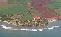
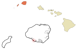
Kaumakani, Hawaii — CDP — 2004 aerial view of Kaumukani Location in Kauai County and the state of Hawaii Coordinates: 21°55′13″N 159°37′27″W / 21.92028°N 159.62417°WCoordinates: 21°55′13″N 159°37′27″W / 21.92028°N 159.62417°W Country United States State Hawaii County Kauai Area - Total 1.0 sq mi (2.7 km2) - Land 1.0 sq mi (2.5 km2) - Water 0.1 sq mi (0.2 km2) Elevation 151 ft (46 m) Population (2000) - Total 607 - Density 635.7/sq mi (245.4/km2) Time zone Hawaii-Aleutian (UTC-10) ZIP code 96747
96769Area code(s) 808 FIPS code 15-30650 GNIS feature ID 0360693 Kaumakani (literally, "place in the wind" in Hawaiian [1]) is a census-designated place (CDP) in Kauaʻi County, Hawaiʻi, United States. The population was 607 at the 2000 census.
Contents
History
Kaumakani was officially known as Makaweli (which means "fearful features" in the Hawaiian Language[2]) for over forty years; Makaweli was an ancient land division (ahupuaʻa).[3] In 1914, the Board on Geographic Names ruled that the community was to be named Makaweli, and only in 1956 did it name the CDP Kaumakani.[4] Kaumakani has its own post office, with the ZIP code of 96747.[5] In 2008, a small settlement to the west at 21°55′59″N 159°38′51″W / 21.93306°N 159.6475°W known as Pakala Village was designated its own CDP,[6] and has its own post office with code 96769.[7][8] Makaweli Landing at Pākala was called Robinson's Landing, since the family of Aubrey Robinson ran a private ferry to their island of Niʻihau.[9] Pākala means "the sun shines" in Hawaiian.[10]
Geography
Kaumakani is located on the southern shore of Kauaʻi island at 21°55′13″N 159°37′27″W / 21.92028°N 159.62417°W (21.920292, -159.624281)[11]. The main road is Kaumualiʻi Highway, Route 50.
According to the United States Census Bureau, the CDP has a total area of 1.0 square mile (2.6 km2), of which, 0.9 square miles (2.3 km2) of it is land and 0.1 square miles (0.26 km2) of it (8.57%) is water.
Demographics
As of the census[12] of 2000, there were 607 people, 207 households, and 162 families residing in the CDP. The population density was 635.7 people per square mile (246.7/km²). There were 234 housing units at an average density of 245.1 per square mile (95.1/km²). The racial makeup of the CDP was 4% White, 77% Asian, 2% Pacific Islander, <1% from other races, and 16% from two or more races. Hispanic or Latino of any race were 5% of the population.
There were 207 households out of which 33% had children under the age of 18 living with them, 60% were married couples living together, 9% had a female householder with no husband present, and 21% were non-families. 18% of all households were made up of individuals and 9% had someone living alone who was 65 years of age or older. The average household size was 2.93 and the average family size was 3.34.
In the CDP the population was spread out with 26% under the age of 18, 6% from 18 to 24, 28% from 25 to 44, 20% from 45 to 64, and 20% who were 65 years of age or older. The median age was 40 years. For every 100 females there were 104.4 males. For every 100 females age 18 and over, there were 102.7 males.
The median income for a household in the CDP was $34,583, and the median income for a family was $41,250. Males had a median income of $26,429 versus $23,654 for females. The per capita income for the CDP was $14,024. About 9% of families and 11% of the population were below the poverty line, including 11% of those under age 18 and 8% of those age 65 or over.
References
- ^ Lloyd J. Soehren (2010). "lookup of Kaumakani ". in Hawaiian Place Names. Ulukau, the Hawaiian Electronic Library. http://ulukau.org/gsdl2.5/cgi-bin/hpn?l=en&a=d&d=HASH7ebc62c4bbd4b3d6d26849. Retrieved October 12, 2010.
- ^ Mary Kawena Pukui, Samuel Hoyt Elbert and Esther T. Mookini (2004). "lookup of Makaweli ". in Place Names of Hawai'i. Ulukau, the Hawaiian Electronic Library, University of Hawaii Press. http://wehewehe.org/gsdl2.5/cgi-bin/hdict?j=pp&l=en&q=Makaweli&d=. Retrieved October 12, 2010.
- ^ Lloyd J. Soehren (2010). "lookup of Makaweli ". in Hawaiian Place Names. Ulukau, the Hawaiian Electronic Library. http://ulukau.org/gsdl2.5/cgi-bin/hpn?l=en&a=d&d=HASH0b407e4c1017c7274ab477. Retrieved October 12, 2010.
- ^ U.S. Geological Survey Geographic Names Information System: Kaumakani
- ^ Zip Code 96747 Lookup
- ^ U.S. Geological Survey Geographic Names Information System: Pakala Village Retrieved October 12, 2010.
- ^ Lloyd J. Soehren (2010). "lookup of Pakala ". in Hawaiian Place Names. Ulukau, the Hawaiian Electronic Library. http://ulukau.org/gsdl2.5/cgi-bin/hpn?l=en&a=d&d=HASHea8efcc5632adf71ebf0eb. Retrieved October 12, 2010.
- ^ Zip Code 96769 Lookup
- ^ John R. K. Clark (2004). "lookup of Makaweli ". in Hawai'i Place Names: Shores, Beaches, and Surf Sites. Ulukau, the Hawaiian Electronic Library, University of Hawaii Press. http://wehewehe.org/gsdl2.5/cgi-bin/hdict?j=cl&l=en&q=Makaweli&d=. Retrieved October 12, 2010.
- ^ John R. K. Clark (2004). "lookup of Pakala ". in Hawai'i Place Names: Shores, Beaches, and Surf Sites. Ulukau, the Hawaiian Electronic Library, University of Hawaii Press. http://wehewehe.org/gsdl2.5/cgi-bin/hdict?j=cl&l=en&q=Pakala&d=. Retrieved October 12, 2010.
- ^ "US Gazetteer files: 2010, 2000, and 1990". United States Census Bureau. 2011-02-12. http://www.census.gov/geo/www/gazetteer/gazette.html. Retrieved 2011-04-23.
- ^ "American FactFinder". United States Census Bureau. http://factfinder.census.gov. Retrieved 2008-01-31.
Municipalities and communities of Kauai County, Hawaii County seat: Lihue CDPs Unincorporated
communitiesCategories:- Census-designated places in Kauai County, Hawaii
- Populated places on Kauai
- Populated places in the United States with Asian American majority populations
Wikimedia Foundation. 2010.


