- Wailua, Hawaii
Infobox Settlement
official_name = Wailua, Hawaii
other_name =
native_name =
nickname =
settlement_type = CDP
motto =
imagesize =
image_caption =
flag_size =
image_
seal_size =
image_shield =
shield_size =
image_blank_emblem =
blank_emblem_type =
blank_emblem_size =
imagesize =
image_caption =
flag_size =
image_
seal_size =
image_shield =
shield_size =
image_blank_emblem =
blank_emblem_type =
blank_emblem_size =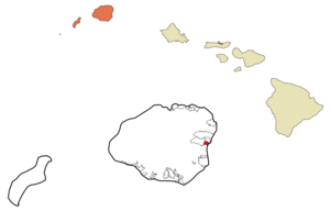
mapsize =
map_caption = Location in Kauai County and the state ofHawaii
mapsize1 =
map_caption1 =
image_dot_
dot_mapsize =
dot_map_caption =
dot_x =
dot_y =
pushpin_
pushpin_label_position =
pushpin_map_caption =
pushpin_mapsize =
subdivision_type = Country
subdivision_name =United States
subdivision_type1 = State
subdivision_name1 =Hawaii
subdivision_type2 = County
subdivision_name2 = Kauai
subdivision_type3 =
subdivision_name3 =
subdivision_type4 =
subdivision_name4 =
government_footnotes =
government_type =
leader_title =
leader_name =
leader_title1 =
leader_name1 =
leader_title2 =
leader_name2 =
leader_title3 =
leader_name3 =
leader_title4 =
leader_name4 =
established_title =
established_date =
established_title2 =
established_date2 =
established_title3 =
established_date3 =
area_magnitude =
unit_pref = Imperial
area_footnotes =
area_total_km2 = 3.7
area_land_km2 = 3.3
area_water_km2 = 0.4
area_total_sq_mi = 1.4
area_land_sq_mi = 1.3
area_water_sq_mi = 0.1
area_water_percent =
area_urban_km2 =
area_urban_sq_mi =
area_metro_km2 =
area_metro_sq_mi =
area_blank1_title =
area_blank1_km2 =
area_blank1_sq_mi =
population_as_of = 2000
population_footnotes =
population_note =
population_total = 2083
population_density_km2 = 624.9
population_density_sq_mi = 1618.6
population_metro =
population_density_metro_km2 =
population_density_metro_sq_mi =
population_urban =
population_density_urban_km2 =
population_density_urban_sq_mi =
population_blank1_title =
population_blank1 =
population_density_blank1_km2 =
population_density_blank1_sq_mi =
timezone = Hawaii-Aleutian
utc_offset = -10
timezone_DST =
utc_offset_DST =
latd = 22
latm = 3
lats = 31
latNS = N
longd = 159
longm = 20
longs = 30
longEW = W
elevation_footnotes =
elevation_m = 6
elevation_ft = 20
postal_code_type =
postal_code =
area_code = 808
blank_name = FIPS code
blank_info = 15-77000
blank1_name = GNIS feature ID
blank1_info = 0364739
website =
footnotes = Wailuā (literally, "two waters" in Hawaiian [Cite book | author=Pukui, Mary Kawena | authorlink= | coauthors= | title=Place Names of Hawaii | date= | publisher=University of Hawaii Press | location= | isbn=0-8248-0524-0 | pages=] ) is acensus-designated place (CDP) in Kauaokinai County, Hawaiokinai,United States . The population was 2,083 at the 2000 census.Geography
Wailuā is located at coor dms|22|3|31|N|159|20|30|W|city (22.058631, -159.341761)GR|1. Nounou Mountain, also known as the "Sleeping Giant", is about 1200 feet tall and divides coastal Wailuā from inland Wailuā. Inland Wailuā is often referred to as a
bedroom community , since it is home to many, but lacks any commercial or government facilities. Coastal Wailuā is a significant commercial center, with many hotels and condominiums for visitors. The Wailuā River is the only navigable river in the state of Hawaiokinai and is a center of activity for locals (water skiing, kayaking) and visitors (boat tour of Fern Grotto).According to the
United States Census Bureau , the CDP has a total area of 1.4square mile s (3.7km² ), of which, 1.3 square miles (3.3 km²) of it is land and 0.1 square miles (0.4 km²) of it (9.79%) is water.Demographics
As of the
census GR|2 of 2000, there were 2,083 people, 781 households, and 549 families residing in the CDP. Thepopulation density was 1,618.6 people per square mile (623.5/km²). There were 1,211 housing units at an average density of 941.0/sq mi (362.5/km²). The racial makeup of the CDP was 29.72% White, 0.77% African American, 0.48% Native American, 34.81% Asian, 8.50% Pacific Islander, 0.62% from other races, and 25.11% from two or more races. Hispanic or Latino of any race were 7.11% of the population.There were 781 households out of which 30.7% had children under the age of 18 living with them, 52.1% were married couples living together, 12.4% had a female householder with no husband present, and 29.7% were non-families. 23.8% of all households were made up of individuals and 8.1% had someone living alone who was 65 years of age or older. The average household size was 2.67 and the average family size was 3.16.
In the CDP the population was spread out with 25.4% under the age of 18, 6.2% from 18 to 24, 25.3% from 25 to 44, 25.6% from 45 to 64, and 17.4% who were 65 years of age or older. The median age was 41 years. For every 100 females there were 102.0 males. For every 100 females age 18 and over, there were 98.2 males.
The median income for a household in the CDP was $45,875, and the median income for a family was $52,083. Males had a median income of $34,615 versus $25,380 for females. The
per capita income for the CDP was $20,231. About 8.7% of families and 8.9% of the population were below thepoverty line , including 9.5% of those under age 18 and none of those age 65 or over.References
External links
Wikimedia Foundation. 2010.