- Maputo Bay
-
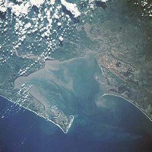 Maputo Bay from space, January 1990
Maputo Bay (Baía de Maputo), formerly Delagoa Bay, Baía da Lagoa (in Portuguese) is an inlet of the Indian Ocean on the coast of Mozambique, between 25° 40' and 26° 20' S, with a length from north to south of over 90 km long and 32 km wide.[1]
Description
The bay is the northern termination of the series of lagoons which line the coast from Saint Lucia Bay. The opening is toward the N.E. The southern part of the bay is formed the Machangulo peninsula, which on its inner or western side affords safe anchorage. At its N.W. point is Port Melville. North of the peninsula is Inhaca Island, and beyond it a smaller island known as Elephants Island.
In spite of a bar at the entrance and a number of shallows within, Maputo Bay forms a valuable harbour, accessible to large vessels at all seasons of the year. The surrounding country is low and very unhealthy, but the island of Inyak has a height of 73 m, and is used as a sanatorium. A river 3.7 to 5.5 m deep, known as the Manhissa or Komati, enters the bay at its northern end; several smaller streams, the Matola (from the north), the Umbeluzi (from the west), and the Tembe (from the south), from the Lebombo Mountains, meet towards the middle of the bay in the estuary called by the Portuguese the Espírito Santo, but generally known as the English river; and the Maputo, which has its headwaters in the Drakensberg, enters in the south, as also does the Umfusi river. These rivers are the haunts of the hippopotamus and the crocodile.
History
The bay was discovered by the Portuguese navigator António de Campo, one of Vasco da Gama captains, in 1502. In 1544 the merchant trader Lourenço Marques explored the upper reaches of the estuaries leading into the bay. Subsequently King John III ordered the Bay to be named Baia de Lourenço Marques. Lourenço Marques is reputed to have named the bay Baía da Lagoa (Portuguese: "Bay of the lagoon"). The origin of the more commonly known name Delagoa Bay is unknown. One interpretation is that Baia da Lagoa has been corrupted to Delagoa Bay. Another interpretation is that the goa in the name refers to the Portuguese colony Goa, and that Delagoa Bay was a port of call for Portuguese merchant ships on the way from Goa to Portugal.
In 1720 the Dutch East India Company built a fort and factory called Lijdzaamheid (Lydsaamheid) on the spot of Lourenço Marques (now Maputo), since April 1721 governed by an Opperhoofd (Chief facor), under authority of the Dutch Cape Colony, interrupted by Taylor's pirate occupation from April 1722 to 28 August 1722; in December 1730 the settlement was abandoned.
Thereafter the Portuguese had - intermittently - trading stations in the Espírito Santo estuary. These stations were protected by small forts, usually incapable, however, of withstanding attacks by the natives.
In 1823 Captain (afterwards Vice-Admiral) W. F. W. Owen, of the Royal Navy, finding that the Portuguese exercised no jurisdiction south of the settlement of Lourenço Marques, concluded treaties of cession with native chiefs, hoisted the British flag, and appropriated the country from the English river southwards; but when he visited the bay again in 1824 he found that the Portuguese, disregarding the British treaties, had concluded others with the natives, and had endeavoured (unsuccessfully) to take military possession of the country. Captain Owen rehoisted the British flag, but the sovereignty of either power was left undecided till the claims of the Transvaal Republic rendered a solution of the question urgent. In the meantime Great Britain had taken no steps to exercise authority on the spot, while the ravages of Zulus confined Portuguese authority to the limits of their fort. In 1835 Boers, under a leader named Orich, had attempted to form a settlement on the bay, which is the natural outlet for the Transvaal; and in 1868 the Transvaal president, Marthinus Pretorius, claimed the country on each side of the Maputa down to the sea. In the following year, however, the Transvaal acknowledged Portugal's sovereignty over the bay.
In 1861 Navy Captain Bickford, had declared Inhaca and Elephant islands British territory; an act protested against by the Lisbon authorities. In 1872 the dispute between Great Britain and Portugal was submitted to the arbitration of Adolphe Thiers, the French president; and on 19 April 1875 his successor, Marshal MacMahon, declared in favor of the Portuguese. It had been previously agreed by Great Britain and Portugal that the right of pre-emption in case of sale or cession should be given to the unsuccessful claimant to the bay. Portuguese authority over the interior was not established until some time after the MacMahon award; nominally the country south of the Manhissa river was ceded to them by the Matshangana chief Umzila in 1861.
In 1889 another dispute arose between Portugal and Great Britain in consequence of the seizure by the Portuguese of the railway running from the bay to the Transvaal. This dispute was referred to arbitration, and in 1900 Portugal was condemned to pay nearly 1,000,000 pounds in compensation to the shareholders in the railway company.
Sources and references
- Sir E. Hertslet, The Map of Africa by Treaty, iii. 991-998 (London, 1909)- an account of the Delagoa Bay arbitration proceedings
- the British blue-book, Delagoa Bay, Correspondence respecting the Claims of Her Majestys Government (London, 1875)
- L. van Deventer, La Hollande et la Baie Delagoa (The Hague, 1883)
- G. McC. Theal, The Portuguese in South Africa (London, 1896), and History of South Africa since September 179,f, vol. v. (London, 1908). The Narrative of Voyages to explore the shores of Africa, performed under direction of Captain W. F. W. Owen, RN. (London, 1833) contains much interesting information concerning the district in the early part of the 19th century.
- WorldStatesmen- Mozambique
 This article incorporates text from a publication now in the public domain: Chisholm, Hugh, ed (1911). Encyclopædia Britannica (11th ed.). Cambridge University Press.
Dutch Empire Colonies and trading posts of the Dutch East India Company (1602-1798) GovernoratesAmbon · Banda · Batavia · Cape Colony · Ceylon · Coromandel · Formosa · Northeast coast of Java · Makassar · Malacca · MoluccasDirectoratesCommandmentsResidenciesSettlements with an opperhoofdColonies and trading posts of the Dutch West India Company (1621-1792) Colonies in the AmericasAcadia · Berbice† · Cayenne · Curaçao and Dependencies · Demerara · Essequibo · Brazil · New Netherland · Pomeroon · Sint Eustatius and Dependencies · Suriname‡ · Tobago · Virgin IslandsTrading posts in Africa† Governed by the Society of Berbice · ‡ Governed by the Society of Suriname Settlements of the Noordsche Compagnie (1614-1642) SettlementsColonies of the Kingdom of the Netherlands (1815-1962) Until 1825Until 1853Until 1872Until 1945Until 1954Until 1962† Became constituent countries of the Kingdom of the Netherlands; Suriname gained full independence in 1975, Curaçao and Dependencies was renamed to the Netherlands Antilles, which was eventually dissolved in 2010. Kingdom of the Netherlands (1954-Present) Constituent countriesPublic bodies of the NetherlandsCategories:- Former Dutch colonies
- Bays of Mozambique
- Maputo River
- Geography of Maputo

Wikimedia Foundation. 2010.