- Condover
-
Coordinates: 52°38′53″N 2°45′00″W / 52.648°N 2.75°W
Condover 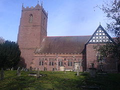
Condover Parish Church viewed from the south side, whose earliest parts date from c.12 A.D.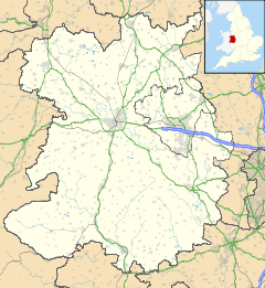
 Condover
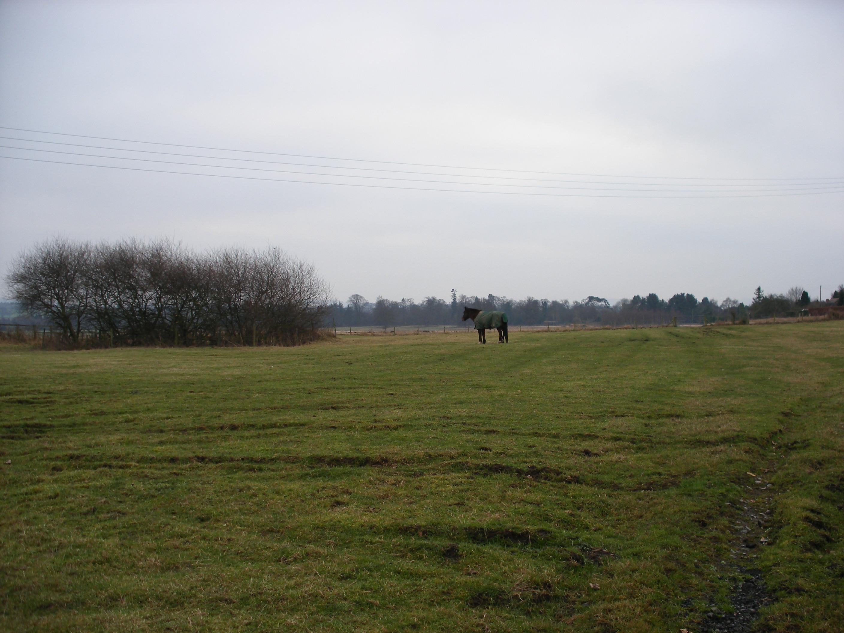
Condover shown within ShropshirePopulation 659 OS grid reference SJ493060 Parish Condover Unitary authority Shropshire Ceremonial county Shropshire Region West Midlands Country England Sovereign state United Kingdom Post town SHREWSBURY Postcode district SY3 Dialling code 01743 Police West Mercia Fire Shropshire Ambulance West Midlands EU Parliament West Midlands UK Parliament Shrewsbury and Atcham List of places: UK • England • Shropshire 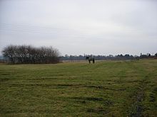 The geographic centre of Shropshire, in a field just north of the village
Condover is a village and civil parish in Shropshire, England. It lies 4.7 miles (7.8 kilometres) south of the county town of Shrewsbury, and just east of the A49. The Cound Brook flows through the village on its way from the Stretton Hills to a confluence with the River Severn. Condover is near to the villages of Dorrington and Bayston Hill, and is the nearest notable settlement to the spot that is the centre point of the geographic county of Shropshire. The centre of the county lies just to the north in a field.[1] The population of the Condover parish was estimated as 1,972 for 2008, of which an estimated 659 live in the village of Condover itself.[2]
Condover contains a higher than normal proportion of Grade II and Grade I listed buildings and over half of the village has been classified as a conservation area since 1976.[3] The more than forty listed structures in Condover range from six separate early cruck-framed buildings and many black-and-white timbered cottages to the present-day Vicarage and several funerary monuments in the churchyard. Of the early half-timbered houses, the most impressive are Church House, the Old School House and the Small House that is now known as Condover Court.[4]
The parish contains two industrial estates, two sand and gravel quarries and a projected borough re-cycling plant is currently planned and under discussion. Villagers and the Parish Council are agreed that there should be no increase in the volume of heavy traffic in the Parish arising from the plant and would regret the detrimental effect to such village services as the post office, shops, primary school and other regular services.
Contents
History
Medieval beginnings
During Saxon times between 613 and 1017 the village was the principal settlement in the Hundred of Condover, an administrative area that was large enough to sustain approximately one hundred households. By the 11th century, Condover was a royal manor held by King Edward the Confessor. It formed a significant part of the great Royal forest known as The Long Forest that stretched almost the full length of South Shropshire.
The Domesday Book surveyed in 1086 referred to it as Conendovre, and the Norman manor house is believed to have stood on the site now occupied by Church House, situated a short distance north west of the Church. It would also appear that a mill stood on the Cound Brook in the village which produced a very good annual income. At the time of the Domesday census, Condover was the property of Roger de Montgomerie, 1st Earl of Shrewsbury, who had been given seven eighths of Shropshire by his cousin King William I in 1071. The revenues of the manor were later forfeited by Robert de Bellême, Earl Roger’s heir, and passed into Royal hands once more under King Henry I. As with other royal manors, the affairs of Condover were managed by the local Shire reeve or sheriff, whose duty it was to keep the King’s forest and manor well stocked and maintained.
In 1226, King Henry III visited Shrewsbury to meet his brother-in-law, Prince Llewellyn ap Gruffydd of Wales. Condover was offered to Llewellyn as a gesture of good will, but sustained wars and skirmishes between England and Wales throughout the 13th Century ensured that stable ownership of Condover manor and Hundred did not settle for nearly three hundred years.
Later history
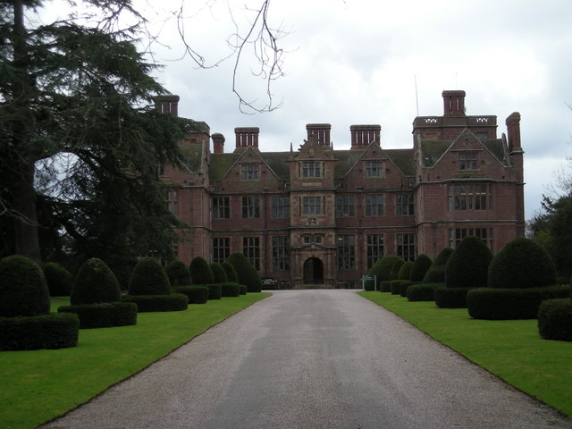
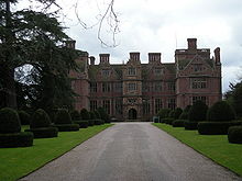 Condover hall from the front driveway
The Royal manor switched in and out of Crown Tenure until, in 1586, Queen Elizabeth I finally made a charter grant of the Condover manor lands to Chief Justice Thomas Owen, a Member of Parliament and Recorder of Shrewsbury. Owen commenced the construction of the current Condover Hall but died before it was completed. The hall remained in the ownership of the Owen family for over three hundred years. In 1870-72, John Marius Wilson's Imperial Gazetteer of England and Wales described Condover thus:
- "CONDOVER, a village, a parish, a sub-district, and a hundred, in Salop. The village stands on an affluent of the river Severn, adjacent to the Shrewsbury and Hereford railway, 4½ miles S of Shrewsbury; and has a station on the railway, and a post office under Shrewsbury. The parish includes also the villages of Chatford and Dorrington. Acres, 7, 422. Real property, £14, 431. Pop., 1, 871. Houses, 376. The property is subdivided. Condover House is the seat of E. W. S. Owen, Esq.; and was built, about 1590, by Chief Justice Owen. The living is a vicarage in the diocese of Lichfield. Value, £258.* Patron, R. Cholmondely, Esq. The church is chiefly Norman; contains monuments of the Owens, one of them by Roubiliac; and is good. The p. curacy of Dorrington is a separate benefice. Charities, £66. -The sub-district is in Atcham district; and contains fourteen parishes. Acres, 37, 057. Pop., 6, 063. Houses, 1, 157. -The hundred includes most of the sub-district; extends considerably beyond it; and is cut into the divisions of Condover and Cound. Acres, 25, 630 and 19, 684. Pop. of the whole, 6, 551. Houses, 1, 261."
On page 112 of Magna Carta Ancestry by Douglas Richardson and Kimball Everingham it is recorded that Anne Owen, daughter of Roger Owen esq and The Honourable Alice of Condover Hall, married Sir St John Booth of Dunham-Massey, Cheshire in 1662 and they had a son named Thomas in 1663.
In 1930 there was a Great Western Railway "Hall Class 4900" steam locomotive No. 4915 with a 4-6-0 configuration named "Condover Hall" that remained in regular service until 1965. In the 1980s Hornby toys issued an electric model replica of the engine.
World War Two
RAF Condover opened in August 1942 and was used variously as a fighter base, a bomber base and a training base during the Second World War, closing in June 1945.[5] Many of the original buildings including the control tower still stand although most of the three concrete runways have been removed. RAF Condover now forms a major part of Berriewood Farm and Condover Industrial Estate. Condover Hall was commandeered as the station's officers' mess during the station's operational years.
Between the latter years of the war and the autumn of 1947 Condover was the site of a Prisoner of War (POW) camp for German airmen, who were employed as farm labourers in the local area. The prisoners were housed in the former WAAF accommodation huts at RAF Condover. Several of the POWs settled permanently in the Shrewsbury area and married local women.
A residential school
The Elizabethan manor house in Condover, Condover Hall was sold to and operated by the RNIB as the residential Condover Hall School for the Blind until 2005.[6] Sold to the private Priory Educational Group, the hall later became home to Condover Horizon School for autistic children but the Priory Group closed the school and college in mid 2009 and the property was again placed on the market. In 2011 the house was bought by JCA Adventure and now hosts residential adventure holidays for children.
Condover in the media
The lanes, footpaths and woodlands around Condover and Bomere Pool featured in several of the medieval detective novels about Brother Cadfael by novelist Ellis Peters.
In 1988 the BBC filmed a three part documentary about the RNIB residential school at Condover Hall and the children were filmed extensively in and around the village.
Governance
Historical
Condover originally formed a principal part of the ancient Hundred of Condover.
Parish Council
There are 12 parish councillors representing Condover, which is a warded parish:
- Condover Ward is represented by five Parish Councillors
- Dorrington Ward is represented by four Parish Councillors
- Ryton Ward is represented by one Parish Councillor
- Stapleton Ward is represented by two Parish Councillors
County
The parish, along with a number of others to its south, is part of the Burnell electoral division, which returns one councillor to Shropshire Council.
Westminster
The parish is part of the Shrewsbury and Atcham parliamentary constituency, and the Member of Parliament since 2005 is Daniel Kawczynski of the Conservative Party.
Demographics
Historical
In the 1801 census Condover's total population was 1,251. In 1901 it was 1,658 and by 1971 the population had fallen to 1,488.
Current
The population of the Condover parish was estimated as 1,972 for 2008, of which an estimated 659 live in the village of Condover itself.[2]
Geography
Waterway
The village of Condover is situated in a low lying area, towards the southern end of the Shropshire-Severn plain. The gently undulating land in the vicinity is bisected by Cound Brook, an important local tributary of the River Severn, which rises in the Stretton Hills some seven miles to the south west.
Geology
Condover stands in the lee of an outcropping spur, consisting of a Pre-Cambrian limestone and sandstone sedimentary rock extension of the Longmyndian range, intruding into the Shropshire-Severn plain with major appearances at Longden, Lyth Hill, Bayston Hill, and Sharpstone Hill. North of the River Severn it does not outcrop again until it appears east of Shrewsbury as Haughmond Hill. The sediments were laid down under a vast warm ocean, surrounded by many volcanoes that were ground down by later ice age glaciers which provided the fertile soil that contributed to Condover becoming a successful farming community throughout medieval times.[7] There are still several active geological fault lines underlying the area and on 2 April 1990 Condover experienced an earthquake, measuring 5.4 on the Richter Scale, that was centred on nearby Bishop's Castle.
The village lies just four miles south of Shrewsbury and is separated from the county town by the main A5 Trunk road. It has good road transport links with easy access to both the A49 and A5. To the west lies the pre-cambrian Lyth Hill, with Sharpstone Hill standing to the north, the latter now mostly a major sandstone quarry with little of the hill itself now remaining after several hundred years of constant quarrying activities.[8] Condover is the nearest notable settlement to the spot that is the centre point of the geographic county of Shropshire. The centre of the county lies just to the north in a field.[9]
Sandstone quarrying and gravel sink holes
There are many small sand and gravel quarries located around the village, although the area is still very rural. It was in one of the many gravel bog sink holes near Bomere Pool that the bones of a Woolly mammoth were discovered in 1986. The skeleton is one of the most complete mammoth skeletons ever to be found in the UK and has been dated at 14,000 years old, later than the animals had been previously thought to survive in Europe.[10] There is a model of the Condover mammoth skeleton at the Shropshire Hills Discovery Centre in Craven Arms, along with a reconstruction of how it might have lived. Adjacent to Bomere Pool is a secluded traditional forest of around 125 acres (0.51 km2), woodland that once formed part of Bayston Hill and Condover Royal hunting forest.
Transport
Bus route
Minsterley Motors route 435 (Shrewsbury-Ludlow) runs through and calls at the village.[11]
Cycle route
Regional Cycle Route 32/33 passes through the village, on its way from Betton Strange to Great Ryton.
Education
Primary
The village has its own primary school, Condover Primary School, a Church of England coeducational school with 109 pupils aged between 5 and 11.
Secondary
There is no secondary school in the village, with children over the age of eleven being bussed to attend a range of secondary schools in nearby Meole Brace, Shrewsbury or Church Stretton and the sixth form college in Shrewsbury.
Religious sites
The Anglican village church of St Andrew and St Mary dates from the 12th century and is of a cruciform layout. The late Norman windows have keeled nook-shafts and waterleaf capitals, resting on a continuous string course. The church is built of finely grained local pink sandstone, quarried at Berriefield, with some recycled Roman stones, presumably robbed from a local derelict farmhouse or villa.
- The replacement nave dates from 1664 after the rebuilding of the crossing tower, which collapsed in 1660 also destroying the northern aisle. A master mason called John Orum cut his initials into the northern jamb of the double-chamfered tower arch in 1664. The three-stage western tower was added in 1678 but has a medieval appearance. The chancel was rebuilt in 1868 by Lord of the Manor, Reginald Cholmondeley of Condover Hall who also added the northern family chapel.
- The northern porch, south vestry together with battlements and buttresses to the nave were built during an 1878 restoration by Fairfax Blomfield Wade-Palmer. Stained glass windows were added in 1868, in 1881 and latterly in 1905 with a four pane Infancy of Christ designed by J H Powell.[12]
- The churchyard contains one of the finest collections of funerary sculpture remaining in Shropshire. The fine array of monuments and family tombs largely date from the 18th and 19th centuries. Many of the sculptures and monuments have listed status.
Sports
- Shrewsbury Motocross Club - holds six meets each year at Condover
- Shrewsbury Golf Club established in 1891 now have their main 18 hole golf course at Condover, which opened in 1971.[13]
- Condover Cricket Club play in the Shropshire Cricket League
- Condover Foxes Football Club play in the Shrewsbury Sunday League
Local landmarks and attractions
- Bomere Pool - A private water sports venue, with public footpaths through the woods
- Lyth Hill Country Park - a free entry country park with extensive walks
- Cantlop Bridge - a single span iron bridge designed and built by Thomas Telford.
- Attingham Park - National Trust property, gardens open all year round, house open in summer.
- Wenlock Edge
- Wroxeter Roman City - English Heritage site
Notable people
- Condover was the birthplace of Richard Tarlton (c1530-1588), actor and court jester on whom the Shakespearian character of Yorick is thought to have been the based.
- The famous American author Samuel Langhorne Clemens better known as Mark Twain holidayed at Condover Hall on two occasions during 1873 and 1879.
- Thomas Corser (1793–1876) was a British literary scholar and Church of England clergyman. He was the editor of Collectanea Anglo-Poetica and was curate at Condover between 1816 and 1819.
References
- ^ [1]
- ^ a b ONS MYE Population Estimates 2008
- ^ Condover conservation area map
- ^ Conservation area PDF with many photos
- ^ RAF Condover
- ^ RNIB closure
- ^ Geology of Shropshire
- ^ Sharpstone Hill
- ^ Centre of Shropshire
- ^ Rincon, Paul (17 June 2009). "Mammoths survived late in Britain". BBC News. http://news.bbc.co.uk/1/hi/sci/tech/8106090.stm. Retrieved 18 June 2009.
- ^ Minsterley Motors 435 Service
- ^ Church History
- ^ Shewsbury Golf Club
See also
- Condover Hall
- Condover railway station
- Cantlop Bridge
- RAF Condover
- Bomere Pool
- Cound Brook
External links
 Media related to Condover at Wikimedia Commons
Ceremonial county of Shropshire Boroughs or districts Major settlements Bishop's Castle • Bridgnorth • Broseley • Church Stretton • Cleobury Mortimer • Clun • Craven Arms • Ellesmere • Ludlow • Market Drayton • Much Wenlock • Newport • Oswestry • Shifnal • Shrewsbury • Telford (Dawley • Madeley • Oakengates • Wellington) • Wem • Whitchurch
See also: List of civil parishes in ShropshireRivers Topics Categories:- Civil parishes in Shropshire
- Villages in Shropshire
- Extremities of Shropshire
- Shrewsbury and Atcham


Wikimedia Foundation. 2010.