- North Center, Chicago
-
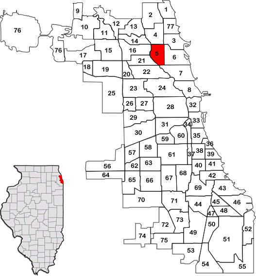
North Center — Community area — Community Area 05 - North Center Streetmap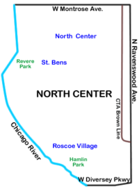 Location within the city of Chicago
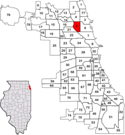
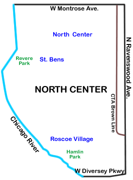
Coordinates: 41°57′N 87°40.8′W / 41.95°N 87.68°WCoordinates: 41°57′N 87°40.8′W / 41.95°N 87.68°W Country United States State Illinois County Cook City Chicago Neighborhoods Area - Total 2.1 sq mi (5.36 km2) Population (2000) - Total 31,895 - Density 15,411.9/sq mi (5,950.6/km2) population down 3.38% from 1990 Demographics - White 68.8% - Black 4.18% - Hispanic 20.4% - Asian 4.15% - Other 2.52% Time zone CST (UTC-6) - Summer (DST) CDT (UTC-5) ZIP Codes parts of 60613, 60618, 60657 Median income $51,758 Source: U.S. Census, Record Information Services North Center is one of the 77 community area of the Chicago, Illinois, located in the city's North Side. North Center is bordered on the north by Montrose Avenue, on the south by Diversey Parkway, on the west by the Chicago River and on the east by Ravenswood Avenue; it includes the neighborhoods of Northcenter, Roscoe Village, St. Ben's, and Hamlin Park. The Brown Line of the Chicago 'L' has stops within the community area at Addison, Irving Park and Montrose.
North Center was settled in the latter part of the 19th century and the early 20th century largely by Germans who worked in what is known as the industrial corridor along Ravenswood Avenue, and the large industrial plants along the Chicago River to the west.
Contents
Neighborhoods
Northcenter
The neighborhood known as Northcenter refers to a neighborhood in the North Side of Chicago, Illinois. Boundaries of Northcenter are Addison on the south, Montrose on the north, the Chicago River on the west and Ravenswood (1800 W) on the east.[1]
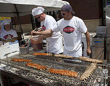 Ribfest Chicago kicks off the summer at the intersection of Irving Park/Lincoln/Damen in the Northcenter neighborhood. Photo: Leigh Hanlon.
Northcenter has grown since the 1870s when the area was only accessible by the Chicago River and Little Fort Road (now known as Lincoln Avenue). Northcenter is considered a vibrant neighborhood with an eclectic mix of retailers, restaurants, live music, live theater, and service-oriented businesses.
Northcenter’s history is deeply rooted in European cultural influences, and that history can be seen in the architectural charm of the homes and buildings from the late 19th and early 20th centuries. Also during this time, the Selig Polyscope Company produced some of America's earliest motion pictures and was based in Chicago. Along Byron Street near Oakley Ave and Western Ave, historic production buildings of the company are still standing and being used as residences and retail businesses. The neighborhood continues to grow and become more culturally diverse. The neighborhood includes bowling alleys, three city parks - including an indoor ice arena, a nearby library, a nearby movie theater complex, and Northcenter Town Square. The Northcenter Chamber of Commerce hosts many free family and community events throughout the year. Northcenter Town Square is also home to a Farmer's Market on Saturdays from June to October.
Roscoe Village
Roscoe Village refers to a neighborhood in the North Side of Chicago, Illinois. While not part of any official city map, Chicago residents perceive the boundaries of the neighborhood to be Addison Street to the north, Belmont Avenue to the south, Ravenswood Avenue to the east and the Chicago River to the west.[2] The primary feature of Roscoe Village is Roscoe Street, which bisects the neighborhood's boundaries between Addison Street and Belmont Avenue. Roscoe Street is populated by businesses and residents. Local historian and longtime neighborhood resident Chuck Betzold notes that people have been living in Roscoe Village since the 18th century, when the area was inhabited by the Fox Indians. Today the area is home to over 6200 residents.
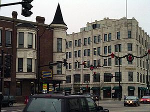 Lincoln Avenue between Cullom and Irving Park in the St. Ben's neighborhood.
St. Ben's
St. Ben's is an unofficial neighborhood with boundaries at Irving Park Road on the north, Addison Street on the south, Damen Avenue on the east, and Western Ave. on the west. It is named for Saint Benedict's Parish, with its Roman Catholic school, on Leavitt Street.[3]
Hamlin Park
The Hamlin Park neighborhood is bounded by Belmont Avenue on the north, Ravenswood Avenue on the east, the Diversey Parkway on the south and the North Branch of the Chicago River on the west. It has its namesake park in the center of the neighborhood. This neighborhood also has the northern half of the Julia C. Lathrop Homes, a CHA housing project.
Places of interest
- Cook County Circuit Court
- Lillstreet Art Center
- American Theatre Company
- WGN-TV Studios
Schools
- Audubon Elementary School
- Bell Elementary School
- Coonley Elementary School
- DeVry Institute of Technology
- Gordon Tech High School
- Jahn Elementary School
- James Adams Alternative High School
- Lane Technical High School
- North Park Elementary School
- Pilgrim Lutheran School
- Schneider Elementary School
- St. Benedict Elementary School
- St. Benedict High School
Former places of interest
- Riverview Park now the site of DeVry University (see above)
References
- "Roscoe Village Chamber of Commerce Map" (http://www.rvcc.biz/map.asp). Retrieved Oct. 24, 2006
- "Roscoe Village Chamber of Commerce Directory" (http://www.rvcc.biz/directory.asp). Retrieved Oct. 24, 2006
- Hadley, Chuck (2002). "A History of Roscoe Village and RVN" (http://www.roscoevillage.org/Default.aspx?pageId=46910). Retrieved Sept. 10, 2008.
- "2000 U.S. Census: Table DP-1. Profile of General Demographics Characteristics: 2000. Geographic area: Roscoe village, Illinois" (http://censtats.census.gov/data/IL/1601765611.pdf) Retrieved Mar. 22, 2005.
External links
- Official City of Chicago North Center Community Map
- North Center Neighborhood Association
- Northcenter Chamber of Commerce
- Roscoe Village Neighbors
- Encyclopedia of Chicago entry on North Center
- Lakeside Community Development Corporation
- Photographs of North Center by Jordan Bettis
Notes
- ^ "Chicago Neighborhood Details:North Center". http://www.chicagohome.com/NHDetails.cfm?NH_ID=32. Retrieved 13 September 2010.
- ^ "Roscoe Village Neighbors website". Roscoe Village Neighbors. http://www.roscoevillage.org. Retrieved 2009-02-17.
- ^ www.chicago.com
City of Chicago Chicago metropolitan area · State of Illinois · United States of America Architecture · Beaches · Climate · Colleges and Universities · Community areas · Culture · Demographics · Economy · Flag · Freeways · Geography · Government · History · Landmarks · Literature · Media · Music · Neighborhoods · Parks · Public schools · Skyscrapers · Sports · Theatre · Transportation
 Category ·
  Portal
Community areas in Chicago Far North side Rogers Park · West Ridge · Uptown · Lincoln Square · Edison Park · Norwood Park · Jefferson Park · Forest Glen · North Park · Albany Park · O'Hare · EdgewaterNorth side Northwest side Central, Near North, and Near South side West and Near West side Southwest side South side Far Southwest side Far Southeast side Chatham · Avalon Park · South Chicago · Burnside · Calumet Heights · Roseland · Pullman · South Deering · East Side · West Pullman · Riverdale · Hegewisch
Albany Park, Chicago Lincoln Square, Chicago Uptown, Chicago Irving Park, Chicago 
Lakeview, Chicago  North Center, Chicago

Avondale, Chicago Logan Square, Chicago Lincoln Park, Chicago Categories:- Community areas of Chicago, Illinois


Wikimedia Foundation. 2010.