- Deuselbach
-
Deuselbach 

 DeuselbachLocation of Deuselbach within Bernkastel-Wittlich district
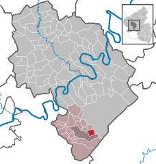
Coordinates 49°45′8″N 7°3′2″E / 49.75222°N 7.05056°ECoordinates: 49°45′8″N 7°3′2″E / 49.75222°N 7.05056°E Administration Country Germany State Rhineland-Palatinate District Bernkastel-Wittlich Municipal assoc. Thalfang am Erbeskopf Mayor Hans-Klaus Hölzemer Basic statistics Area 4.03 km2 (1.56 sq mi) Elevation 460 m (1509 ft) Population 251 (31 December 2010)[1] - Density 62 /km2 (161 /sq mi) Other information Time zone CET/CEST (UTC+1/+2) Licence plate WIL Postal code 54411 Area code 06504 Website www.deuselbach.de Deuselbach is an Ortsgemeinde – a municipality belonging to a Verbandsgemeinde, a kind of collective municipality – in the Bernkastel-Wittlich district in Rhineland-Palatinate, Germany.
Contents
Geography
Location
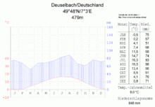 Climate diagram for Deuselbach
The municipality lies in the Hunsrück at the foot of the Erbeskopf. The nearest middle centres are Bernkastel-Kues and Morbach. Trier lies some 31 km away. Deuselbach belongs to the Verbandsgemeinde of Thalfang am Erbeskopf, whose seat is in the municipality of Thalfang.
Climate
The yearly mean temperature is 8 °C.
History
In 1112, Deuselbach had its first documentary mention. After the French Revolution, the Rhine’s left bank, and thereby Deuselbach too, were ceded to France in 1794 and 1795. Through a law from 26 March 1798, the French abolished feudal rights in their zone of occupation. After French rule ended, the village passed in 1814 to the Kingdom of Prussia. Since 1947, it has been part of the then newly founded state of Rhineland-Palatinate. Until administrative reform in Rhineland-Palatinate in 1969, this village in the Hunsrück belonged to the Bernkastel district, whose seat was at Bernkastel-Kues. Today, Deuselbach is part of the Verbandsgemeinde of Thalfang am Erbeskopf.
Politics
Municipal council
The council is made up of 6 council members, who were elected by majority vote at the municipal election held on 7 June 2009, and the honorary mayor as chairman[2].
Economy and infrastructure
In Deuselbach is found a German Weather Service weather station.
References
- ^ "Bevölkerung der Gemeinden am 31.12.2010" (in German). Statistisches Landesamt Rheinland-Pfalz. 31 December 2010. http://www.statistik.rlp.de/fileadmin/dokumente/berichte/A1033_201022_hj_G.pdf.
- ^ Kommunalwahl Rheinland-Pfalz 2009, Gemeinderat
External links
- This article incorporates information from the German Wikipedia.
Categories:- Municipalities in Rhineland-Palatinate
- Bernkastel-Wittlich geography stubs


Wikimedia Foundation. 2010.