- Myrtlewood, Alabama
-
Myrtlewood, Alabama — Town — Location in Marengo County and the state of Alabama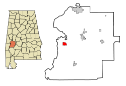
Coordinates: 32°14′50″N 87°56′50″W / 32.24722°N 87.94722°W Country United States State Alabama County Marengo Area – Total 2.6 sq mi (6.7 km2) – Land 2.6 sq mi (6.7 km2) – Water 0 sq mi (0 km2) Elevation 220 ft (67 m) Population (2000) – Total 139 – Density 53.5/sq mi (20.7/km2) Time zone Central (CST) (UTC-6) – Summer (DST) CDT (UTC-5) ZIP code 36763 Area code(s) 334 FIPS code 01-53112 GNIS feature ID 0123626 Myrtlewood is a town in Marengo County, Alabama, United States. At the 2000 census the population was 139.
Geography
Myrtlewood is located at 32°14′50″N 87°56′50″W / 32.24722°N 87.94722°W (32.247254, -87.947141)[1].
According to the U.S. Census Bureau, the town has a total area of 2.6 square miles (6.7 km2), all of it land.
Demographics
As of the census[2] of 2000, there were 139 people, 59 households, and 45 families residing in the town. The population density was 53.6 people per square mile (20.7/km²). There were 76 housing units at an average density of 29.3 per square mile (11.3/km²). The racial makeup of the town was 79.14% White and 20.86% Black or African American. 0.72% of the population were Hispanic or Latino of any race.
There were 59 households out of which 22.0% had children under the age of 18 living with them, 61.0% were married couples living together, 10.2% had a female householder with no husband present, and 23.7% were non-families. 23.7% of all households were made up of individuals and 6.8% had someone living alone who was 65 years of age or older. The average household size was 2.36 and the average family size was 2.76.
In the town the population was spread out with 18.7% under the age of 18, 5.8% from 18 to 24, 25.9% from 25 to 44, 30.2% from 45 to 64, and 19.4% who were 65 years of age or older. The median age was 44 years. For every 100 females there were 95.8 males. For every 100 females age 18 and over, there were 98.2 males.
The median income for a household in the town was $42,188, and the median income for a family was $50,114. Males had a median income of $51,667 versus $31,250 for females. The per capita income for the town was $21,262. There were 4.8% of families and 7.3% of the population living below the poverty line, including 7.1% of under eighteens and 13.0% of those over 64.
References
- ^ "US Gazetteer files: 2010, 2000, and 1990". United States Census Bureau. 2011-02-12. http://www.census.gov/geo/www/gazetteer/gazette.html. Retrieved 2011-04-23.
- ^ "American FactFinder". United States Census Bureau. http://factfinder.census.gov. Retrieved 2008-01-31.
Coordinates: 32°14′50″N 87°56′50″W / 32.247254°N 87.947141°W
Municipalities and communities of Marengo County, Alabama Cities 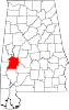
Towns Dayton | Faunsdale | Myrtlewood | Providence | Sweet Water | Thomaston
Unincorporated
communitiesAimwell | Alfalfa | Beaver Creek | Clay Hill | Consul | Coxheath | Dixons Mills | Exmoor | Half Acre | Half Chance | Hampden | Hoboken | Hugo | Jefferson | Lasca | McKinley | Magnolia | Marengo | Moores Valley | Moscow | Nanafalia | Nicholsville | Octagon | Old Spring Hill | Pin Hook | Putnam | Rembert | Salt Well | Shiloh | Siddonsville | Surginer | Vangale | Vineland | Wayne
Ghost town Aigleville
Categories:- Populated places in Marengo County, Alabama
- Towns in Alabama


Wikimedia Foundation. 2010.