- Marengo, Alabama
-
Marengo, Alabama Location within the state of Alabama
 Marengo, Alabama
Coordinates: 32°3′25.52″N 87°48′51.01″W / 32.0570889°N 87.8141694°W Country United States State Alabama County Marengo Elevation 180 ft (55 m) Time zone Central (CST) (UTC-6) – Summer (DST) CDT (UTC-5) ZIP code Area code(s) 334 Marengo is an unincorporated community in Marengo County, Alabama.[1] Marengo had a post office at one time, but it no longer exists.[2]
Geography
Marengo is located at 32°03′26″N 87°48′51″W / 32.05709°N 87.81417°WCoordinates: 32°03′26″N 87°48′51″W / 32.05709°N 87.81417°W and has an elevation of 180 feet (55 m).[1]
References
Municipalities and communities of Marengo County, Alabama Cities 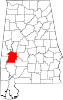
Towns Dayton | Faunsdale | Myrtlewood | Providence | Sweet Water | Thomaston
Unincorporated
communitiesAimwell | Alfalfa | Beaver Creek | Clay Hill | Consul | Coxheath | Dixons Mills | Exmoor | Half Acre | Half Chance | Hampden | Hoboken | Hugo | Jefferson | Lasca | McKinley | Magnolia | Marengo | Moores Valley | Moscow | Nanafalia | Nicholsville | Octagon | Old Spring Hill | Pin Hook | Putnam | Rembert | Salt Well | Shiloh | Siddonsville | Surginer | Vangale | Vineland | Wayne
Ghost town Aigleville
Categories:- Unincorporated communities in Alabama
- Populated places in Marengo County, Alabama
- Alabama geography stubs


Wikimedia Foundation. 2010.