- Dundas, New South Wales
-
Dundas
Sydney, New South Wales
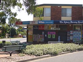
Station Street shopsPopulation: 9,676[1] Postcode: 2117 Location: 22 km (14 mi) north-west of Sydney CBD LGA: City of Parramatta State District: Parramatta Federal Division: Parramatta, Bennelong Suburbs around Dundas: Oatlands Telopea Dundas Valley North Parramatta Dundas Ermington Parramatta Rydalmere Ermington Dundas is a suburb of Sydney, in the state of New South Wales, Australia. Dundas is located 22 kilometres north-west of the Sydney central business district in the local government area of the City of Parramatta.
Contents
History
Dundas and surrounding areas were originally known as "The Ponds", a name still reflected in The Ponds Creek. The first private land grants in Sydney made in 1791 were in what is now North East Dundas and adjoining Dundas Valley and Ermington.
The name Dundas was first used in the area in 1799, named for the Dundas family of Scotland. There are over 100 places named in their honour, mostly in parts of the former British Empire.[2]
Transport
Dundas railway station is on the Carlingford line of the CityRail network. To the south, the next station is Rydalmere and to the north, Telopea. The station is located on Station Street, connects to Kissing Point Road by footpath. There are few Sydney Buses routes that go past Dundas.
545: Parramatta to Chastwood (Kissing Point Road) 720: Student bus route (Cumberland High School Dunmore Ave to Calder Road)
Schools
St Patrick's Marist College Dundas, located on Kirby Street, is a Catholic secondary school and plays host to the Shamrocks Dundas JRLFC Football Club.
- Dundas Public School is located on Kissing Point Road, opposite Calder Road.
Churches
- The local Anglican Church meets at Telopea on Saturday evenings and at Dundas on Sundays.[3]
References
Suburbs and localities within the City of Parramatta · Western Sydney · Sydney Camellia · Carlingford · Chester Hill · Clyde · Constitution Hill · Dundas · Dundas Valley · Eastwood · Epping · Ermington · Granville · Harris Park · Model Farms · Northmead · Oatlands · Old Toongabbie · Parramatta · North Parramatta · Pendle Hill · Rosehill · Rydalmere · South Granville · Telopea · Toongabbie · Winston Hills · Wentworthville · Westmead
Coordinates: 33°48′15″S 151°02′06″E / 33.80404°S 151.03510°E
Categories:- Suburbs of Sydney
- Sydney geography stubs
Wikimedia Foundation. 2010.

