- North Parramatta, New South Wales
-
North Parramatta
Sydney, New South Wales
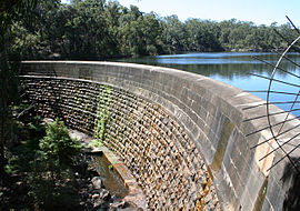
Masonry arch wall at Lake ParramattaPostcode: 2151 Location: 24 km (15 mi) north-west of Sydney CBD LGA: City of Parramatta State District: Parramatta Federal Division: Parramatta Suburbs around North Parramatta: Northmead North Rocks Carlingford Northmead North Parramatta Oatlands Westmead Parramatta Rydalmere North Parramatta is a suburb of Sydney, in the state of New South Wales, Australia. North Parramatta is located 24 kilometres north-west of the Sydney central business district in the local government area of the City of Parramatta. Parramatta is a separate suburb to the south.
Contents
History
Aboriginal culture
The Darug people had lived in the area for many generations, and regarded the area as a food bowl, rich in food from the river and forests. They called the area Baramada or Burramatta ('Parramatta') which means "the place where the eels lie down"[1].
Landmarks
North Parramatta is dominated by Lake Parramatta and The King's School, which together comprise almost 50% of the land area.
References
- ^ Troy, Jakelin. "The Sydney Language". Macquarie Aboriginal Words. Sydney: Macquarie Library. p. 76.
External links
- http://www.parracity.nsw.gov.au/
- North Parramatta, New South Wales is at coordinates 33°48′11″S 151°00′20″E / 33.80315°S 151.00548°ECoordinates: 33°48′11″S 151°00′20″E / 33.80315°S 151.00548°E
Suburbs and localities within the City of Parramatta · Western Sydney · Sydney Camellia · Carlingford · Chester Hill · Clyde · Constitution Hill · Dundas · Dundas Valley · Eastwood · Epping · Ermington · Granville · Harris Park · Model Farms · Northmead · Oatlands · Old Toongabbie · Parramatta · North Parramatta · Pendle Hill · Rosehill · Rydalmere · South Granville · Telopea · Toongabbie · Winston Hills · Wentworthville · Westmead
Categories:- Suburbs of Sydney
- Sydney geography stubs
Wikimedia Foundation. 2010.
