- Davey Street, Hobart
-
Davey Street
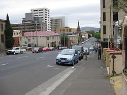
Part of Davey Street, looking north-east from near Anglesea BarracksLength: 2 km (1 mi) Location: Hobart East end:  Brooker Highway /
 Tasman Highway /
 Macquarie Street Hobart, Tasmania
Major
junctions:Sandy Bay Road West end: Southern Outlet /
 Huon Road /
South Hobart, TasmaniaDavey Street is one of the main streets of the central business district of the city of Hobart, capital of Tasmania, Australia. As well as forming the southern border of the CBD, it is part of the A6, technically making it part of the Huon Highway. Like Collins Street, it is named after an early Governor: Tasmania's second Governor, Colonel Thomas (Mad Tom) Davey, Lt. Governor from 1810–1817.
It forms a One-way couplet with Macquarie Street and starts at its junction with the Tasman Highway, the Brooker Highway and Macquarie Street, near the historic Royal Engineers Building. It is four-lane for almost all of its length, providing access to Salamanca, Sandy Bay and the Southern Outlet to Kingston and Huonville.
A little known fact, even among Hobart residents, is that Davey Street sits upon reclaimed land on the edge of the harbour.
Davey Street borders two of the city's largest urban parks — Franklin Square and St David's Park. Prominent buildings in the street include the Executive Building, which houses the Department of Premier and Cabinet, the Hotel Grand Chancellor and Federation Concert Hall, the Hobart Real Tennis Club, and what was the Davey St Telstra exchange (now apartments).
In 2004 ZeroDavey, a controversial new development, was built on the corner of Davey and Hunter Street. This angered residents (who compared it to the back of a refrigerator) as its top story, added on against the advice of local planners and in contravention of the area's planning scheme, is visible above the former skyline of heritage buildings in Hunter Street.
Davey Street is featured as a property in the Australian version of Monopoly.
See also
 Road Infrastructure in greater Hobart
Highways 
Major Roads Bridges Bowen Bridge · Bridgewater Bridge · Jordan River Bridge · Mcgees Bridge · Sorell Causeway · Tasman BridgeUnder construction Proposals Bagdad Bypass · Eastern Ring Road · Hobart Area Transportation Study · Hobart Bypass · Rokeby Bypass · Sorell Bypass · Southern Transport Investment Program Streets of HobartHobart city centre Argyle Street · Barrack Street · Bathurst Street · Brisbane Street · Campbell Street · Collins Street · Davey Street · Elizabeth Street · Goulburn Street · Harrington Street · Liverpool Street · Macquarie Street · Melville Street · Murray Street · Patrick StreetGreater Hobart Coordinates: 42°52′51″S 147°20′03″E / 42.8809°S 147.3342°E
Categories:- Streets in Hobart

Wikimedia Foundation. 2010.