- Hobart Bypass
-
 An Artists impression of the Northside Freeway, proposed in 1965
The Hobart bypass is a proposed concept to Bypass the Central Business District of Hobart, Tasmania. Currently through traffic travels from the Tasman/Brooker Highways down the one-way Davey/Macquarie Couplet to the Southern Outlet. As well as Traffic concerns there is also a call to build the bypass on the grounds that the current traffic arrangement cuts the Central business district off from the Hobart Waterfront.
Contents
Current Alignment
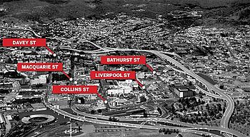
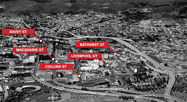
At Present Traffic proceeding to/from the Southern Outlet must pass through the One-way couplet of Davey and Macquarrie Streets for access to The Tasman and Brooker Highways. This current Alignment was implemented in 1987 to coincide with the completion of the Sheraton. It was originally intended that the couplet system would serve as a stop gap measure prior to the construction of a Freeway in the Hobart's Transportation study of 1965.[1][2] Prior to this all Traffic in Hobart was 2-way and had to navigate through the Central business district.
Proposals
Northside Freeway
The Northside Freeway was one of several Traffic soultions proposed in the Hobart Area Transportation Study of 1965.[1][3] The proposed Link was to extend from the Southern Outlet at Davey Street and traverse the foot hills of West Hobart, crossing the Brooker Highway between Melville and Brisbane Streets and passing through the Queens Domain and connecting to the Tasman Highway.[1] The Freeway was designed to be a raised Freeway to avoid the sharp topographical features associated with the Queens Domain.[1]
Tunnels
There has since been several Design proposals for a Tunnel[4] under the city ranging from Cut and cover proposals under Davey/Macquarie Streets to Large scale bored tunnels running From the Southern Outlet through to the Tasman Bridge.
See Also
References
- ^ a b c d Hobart Area Transportation Study. Hobart, Tasmania: Wilbur Smith and Associates. 1965.
- ^ "Kingston & Environs Transport Study". Department of Infrastructure, Energy and Resources. 2006. http://www.transport.tas.gov.au/pdf/publications/transport_study/Kingston_Environs_Transport_Study.pdf. Retrieved 2007-04-30.
- ^ http://www.themercury.com.au/article/2010/11/23/188121_tasmania-news.html
- ^ http://www.abc.net.au/news/stories/2003/03/17/808336.htm
 Road Infrastructure in greater Hobart
Highways 
Major Roads Bridges Bowen Bridge · Bridgewater Bridge · Jordan River Bridge · Mcgees Bridge · Sorell Causeway · Tasman BridgeUnder construction Proposals Bagdad Bypass · Eastern Ring Road · Hobart Area Transportation Study · Hobart Bypass · Rokeby Bypass · Sorell Bypass · Southern Transport Investment ProgramCategories:- Proposed roads in Australia
Wikimedia Foundation. 2010.