- Morganton, Tennessee
-
Morganton — Former town — Morganton in 1939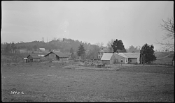 Location within the state of Tennessee
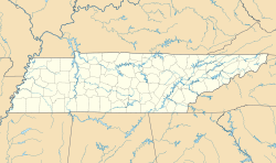
 Morganton
Coordinates: 35°38′36″N 84°13′38″W / 35.64333°N 84.22722°WCoordinates: 35°38′36″N 84°13′38″W / 35.64333°N 84.22722°W Country United States State Tennessee County Loudon Time zone Eastern (EST) (UTC-5) - Summer (DST) EDT (UTC-4) ZIP codes GNIS feature ID Morganton was a community once located in Loudon County, Tennessee, in the southeastern United States. Although now submerged by Tellico Lake, during its heyday in the 19th century Morganton thrived as a flatboat port and regional business center. An important ferry operated at Morganton for nearly 170 years.
Due largely to the decline in river trade that occurred in the mid-19th century with the construction of railroads in East Tennessee, Morganton was mostly deserted by the time the Tennessee Valley Authority started buying up property for the construction of Tellico Dam in the late 1960s. Today, the Morganton Cemetery, which overlooks the now-flooded townsite, is all that remains of the former town. A road and TWRA boat ramp are named for Morganton.
Contents
Geographical setting
The Little Tennessee River rises in the Appalachian Mountains of Georgia and meanders its way through southwestern North Carolina before entering Tennessee, where it flows for roughly 54 miles (87 km) before emptying into the Tennessee River near Lenoir City. The completion of Tellico Dam at the river's mouth in 1979 created a lake that spans the lower 33 miles (53 km) of the river. Morganton was located 13.7 miles (22.0 km) above the mouth of the Little Tennessee at the river's confluence with Bakers Creek, which flows westward from Maryville.[1]
The Morganton site is visible from the junction of East Coast Tellico Parkway and Morganton Road, just west of Greenback. The area is under the management of the Tennessee Valley Authority.
History
Early history, 1800-1860
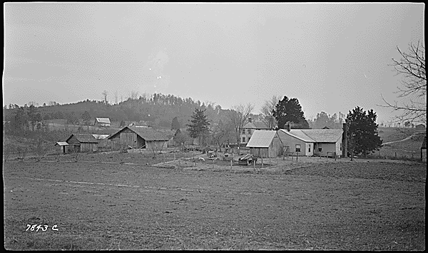
 The former site of Morganton, now under Tellico Lake.
The Morganton area was part of the lands ceded by the Cherokee with the signing of the First Treaty of Tellico in 1798. The first Euro-American settlers had arrived at the mouth of Bakers Creek in 1796, however, when the land was still claimed by the Cherokee.[2] Several major villages of the Overhill Cherokee were located upstream from the Morganton site (the village of Mialoquo was situated just around Wears Bend, on the opposite side of the river), although most of these villages had either been destroyed or were in decline by the late 1790s. Ethnologist James Mooney recorded a Cherokee legend regarding curiously-blazed trees on the banks "opposite Morganton" that supposedly marked the location of hidden mines.[3]
By 1799 a grist mill had been established along Bakers Creek by Hugh and Charles Kelso. The following year, Captain Robert Wear (1781-1846) arrived in the area, establishing a plantation near the mouth of the river and a ferry near the mouth of Bakers Creek. In 1801, an inspection port was established near the ferry, and the small community that developed in its vicinity became known as "Portville." The community of Portville incorporated in 1813 after the Kelso brothers donated land for the formation of a town square. The community chose the name "Morganton" after Gideon Morgan (1751-1830), a Revolutionary War veteran and prominent local merchant.[4][5]
By the 1830s, Morganton had grown to become the main shipping hub and business center in the Little Tennessee region. Flatboats carried local products such as whiskey and hemp to trade throughout the Tennessee Valley— and sometimes as far away as New Orleans— for products such as clothing, salt, and spices. By 1832, the town had its own doctor, hatter's shop, hemp factory, wagon factory, cabinet shop, distillery, and silversmith.[6] A steamboat line connecting Morganton and Knoxville began operating in 1831.[7]
Decline, 1861-1967
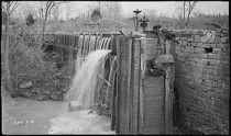 Abandoned mill along Bakers Creek in Morganton, photographed in 1939
In late 1863, at the height of the U.S. Civil War, Confederate General James Longstreet hoped to cross the Little Tennessee at Morganton en route from Chattanooga to Knoxville to dislodge the troops under the command of Ambrose Burnside, who had occupied Knoxville earlier in the year. Longstreet later recalled:
Had the means been at hand for making proper moves I should have marched for the rear of Knoxville via Morganton and Marysville...[8]
As Longstreet lacked the materials to construct a pontoon bridge, however, he was forced to cross the Tennessee River at Loudon, and approach from the west. That same year, however, Union General William T. Sherman crossed the Little Tennessee at Morganton en route to Chattanooga. Sherman tore down several of the town's houses to construct a pontoon bridge.[7]
After the Civil War, railroads slowly replaced riverboats as the preferred mode of shipping and transportation. When the L&N Railroad laid tracks through nearby Greenback in the late 19th century, Morganton slowly declined. In 1947, a bridge near Niles Ferry became toll-free, putting most of the ferries along the Little Tennessee River out of business. The Morganton Ferry was the last to go, folding in 1961.[9]
Archaeological survey, 1978
In 1968, the Tennessee Valley Authority reported 18 houses, a store, and a church at Morganton, all of which were to be torn down in anticipation of the construction of Tellico Dam. In 1978, as the Tellico Dam project was stalled by litigation, University of Tennessee archaeologists conducted a test survey of the Morganton townsite. Several early American artifacts were located, some dating to as early as 1762, as well as several projectile points. The artifacts were similar to those uncovered at the nearby Tellico Blockhouse site, which had been excavated around the same time.[10]
References
- ^ James Polhemus and Richard Polhemus, An Assessment of the Archaeological Potential of Townsite of Morganton in Loudon County, Tennessee (Knoxville, Tenn.: Tennessee Valley Authority, 1978), 1.
- ^ Polhemus and Polhemus, 1.
- ^ James Mooney, Myths of the Cherokee and Sacred Formulas of the Cherokee (Nashville: C and R Elder, 1972), 414.
- ^ Alberta and Carson Brewer, Valley So Wild (Knoxville, Tenn.: East Tennessee Historical Society, 1975), 94-95.
- ^ Polhemus and Polhemus, 1-2.
- ^ Brewer and Brewer, 94-96.
- ^ a b Polhemus and Polhemus, 2.
- ^ Yong Kim, The Sevierville Hill Site: A Civil War Union Encampment on the Southern Heights of Knoxville, Tennessee (Knoxville, Tenn.: University of Tennessee Transportation Center, 1993), 15.
- ^ Brewer and Brewer, 97.
- ^ Polhemus and Polhemus, lithic and ceramic catalogues in An Assessment of the Archaeological Potential of Townsite of Morganton in Loudon County, Tennessee.
Categories:- Geography of Loudon County, Tennessee
- Archaeological sites in Tennessee
- Sunken cities
- Former populated places in Tennessee


Wikimedia Foundation. 2010.