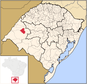
- Manoel Viana
-
Map 
Statistics State: Rio Grande do Sul Meso-region: Micro-Region: Campanha Ocidental Founded: March 20, 1992 Location: 30.589/30° 35' 21" S lat.
55.828/55° 28' 58" W long.Area: 1,390.7 km² Population (2010):
- Total
- Change
- Density
7,074
-
5.61/km²Elevation: 113 m Postal code: 97640-000 Manoel Viana is a small Brazilian town in the western part of the state of Rio Grande do Sul. It has a population of 7,074 (2010). Its elevation is 113 m. It has an area of 1,390.7 square kilometers making it one of the largest municipalities in the state. It is located 590 km west of the state capital of Porto Alegre and east of Alegrete. It is the only municipality that is by the rio Ibicuí
Other
Manoel Viana has a school or a collegiate, churches and a few squares and parks.
External links
- http://www.citybrazil.com.br/rs/manoelviana/ (Portuguese)
- Map and Aerial photos:
- Coordinates: 29°35′21″S 55°28′58″W / 29.58917°S 55.48278°W
- Street maps: Street map from Mapquest, MapPoint or Google
- Satellite images and Aerial photos: Google
Campanha Ocidental Alegrete · Barra do Quaraí · Garruchos · Itaqui · Maçambara · Manoel Viana · Quaraí · São Borja · São Francisco de Assis · Uruguaiana
Categories:- Municipalities of Brazil
- Populated places in Rio Grande do Sul
- Rio Grande do Sul geography stubs
Wikimedia Foundation. 2010.

