- Mulbarton, Norfolk
-
Coordinates: 52°35′14″N 1°13′31″E / 52.5872°N 1.2253°E
Mulbarton 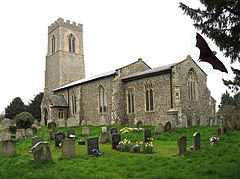

 Mulbarton
Mulbarton shown within NorfolkArea 5.34 km2 (2.06 sq mi) Population 66,000 - Density 12,360 /km2 (32,000 /sq mi) OS grid reference TG187003 Parish Mulbarton District South Norfolk Shire county Norfolk Region East Country England Sovereign state United Kingdom Post town Norwich Postcode district NR14 Police Norfolk Fire Norfolk Ambulance East of England EU Parliament East of England List of places: UK • England • Norfolk Mulbarton is a village and civil parish located south of Norwich in the English county of Norfolk. It covers an area of 5.34 km2 (2.06 sq mi).[1]
The population at the 2001 census was 2,827.[2]
Facilities include an Adnams' public house, The World's End, a social club, 2 convenience stores (One Stop and CO-OP), a church, a fish-and-chip shop, and a chinese takeaway. There is a regular bus service to Norwich, with buses coming every 30 minutes.[citation needed] In the centre of the village is a large common, and a pond where many ducks live.
Mulbarton is famous for having more association football teams than any other village in Norfolk. Its churchyard is famous for having a large population of bats, some of which have been recorded as having the largest wingspans in British recorded natural history.
Contents
Notable people
- Maurice Norman - footballer
War
Both the First and Second World Wars had a profound effect on Mulbarton, affecting not only those who lost their lives in the wars, but the generation of children who missed out on their education in order to do agricultural work during the First World War.
A Roll of Honour in the Church porch lists all the Mulbarton men who served in the 1914-18 war. The 16 who died are highlighted in gold. A total of 90 men went to war, which must have been a high proportion of the men of the village, as it was 19% of the total population (481 in the national census of 1911).
Although the Second World War is within living memory, something of its local impact can also be gleaned from records of Parish Council discussions and from the school Log Book.
The War Memorial in the church lists seven names of those who died in the 1939-45 war.
Mulbarton Wanderers and Belles FC
In 1989, Mulbarton United Youth Formed and five years later Harford Belles formed playing at the South Harford School, Norwich. Four years later Mulbarton Youth FC split and formed Mulbarton Wanderers Youth FC.
In 2000, Harford Belles were awarded the Umbro club of the year title. In 2001, the Belles moved to Mulbarton and joined the Wanderers. They became the Mulbarton Belles and formed one of the largest football clubs in Norfolk.
The Mulbarton Wanderers and Belles were awarded the FA National Football Grass Roots award, presented in Mulbarton by Kevin Keegan. This was later shown on national ITV. The Belles formed their first Ladies senior team.
In 2002, Mulbarton Wanderers and Belles became the first club in Norfolk to be awarded the FA Charter Standard Development award. The Wanderers formed their first Men’s senior team.
In 2004, both senior teams achieved the FA Charter Standard Adult Club award. The club was granted the FA Charter Standard Community Club Award.
In 2005, Mulbarton became the Charter Standard Community Club of the Year for Norfolk.
In 2007, Mulbarton Wanderers and Belles were recognised as the FA Charter Standard Community Club 2007. The Senior Men were recognised as Charter Standard Adult Club of the year.
Mulbarton was originally the home to world famous footballers such as Rivaldo, Diego Maradona and Frank Sinclair. Sinclair and Rivaldo were both in the under 12 team and scored 83 goals in 19 games between them, 74 of them being netted directly from corners. More recently, David Ginola has been seen playing hockey with Iker Casillas at the Mulbarton Common. There has also been talk of of multi-billionaire Roman Abramovich buying the club and setting up a 65,000 seater stadium. This however, has yet to be confirmed.
Church
For centuries the church has been at the hub of village life, not just as a religious institution, but as a provider of housing for villagers, administering charity, and overseeing the work of the school. Both the church and the Methodist chapel have traditionally been at the centre of village celebrations such as coronations, social events and social clubs, and village entertainments.
Common
Today, the common is a recreation area for the rapidly increasing number of people in the village. Its football pitches are used by all ages.
Mulbarton common is famous for being one of the possible locations of King John's lost caravan of gold. Many attempts to locate the hoard, which is thought to have sunk into boggy ground, have been thwarted by the now hard-packed ground and thick undergrowth.
Even in the 19th century, there were day-trips from Norwich to Mulbarton for games on the common and liquid refreshment at the World's End. A move to enclose the common aroused great opposition in 1865, and modern development on the perimeter has been resisted with partial success.
Pubs
Mulbarton had two pubs: the Tradesman's Arms and the World's End. Both had bowls and other sporting clubs. They also hosted a number of clubs and societies, including an Oddfellows Lodge.
Today there is just one pub - the World's End, which offers food as well as beverages. But there is also a licensed social club in the Village Hall. This is the modern successor to the old Parish Hall (often called the Wingfield Hall) that was very near the World's End. For over 60 years, it was the venue for many village activities. Many of these continued when the old school became the Village Hall, and their present home is the modern Village Hall and Social Club near the common.
Schools
Today, Mulbarton has two thriving schools: Mulbarton Infant School and Mulbarton Junior School, both of which give local pupils an excellent education. The predecessor to the modern buildings housing these school stands across the common - now a dental surgery, and before that the Village Hall. It was opened in 1865 as a 'National School' (i.e. run by the Church of England).
Shops
Today, Mulbarton has a Co-oP, a small supermarket with post office, a farm shop at Paddock Farm with a small butchers, bakers, and a chemist shop next to the dental surgery (both in the old school). There is a 24-hour Tesco only 3 miles away, but in the past, the village was well served with shops. Villagers remember that in the past all the shops sold everything, from sugar to paraffin and even crack cocaine was available directly off the shelf.
It also has a mediocre fish and chip shop just behind the chemist and dentist, famous for never handing out bags even if you spend £20.
References
- ^ "Mulbarton parish information". South Norfolk Council. 17 April 2007. http://www.south-norfolk.gov.uk/democracy/Mulbarton_parish.asp. Retrieved 20 June 2009.
- ^ Office for National Statistics & Norfolk County Council 2001 Census population and household counts for unparished urban areas and all parishes (XLS)
External links
- Mulbarton parish website
- Parish council website
- Mulbarton Wanderers and Belles FC
- Mulbarton Village cricket club
- Mulbarton Infant School
- Mulbarton Junior School
Categories:- South Norfolk
- Villages in Norfolk
- Civil parishes in Norfolk


Wikimedia Foundation. 2010.