- Colney
-
Coordinates: 52°37′31″N 1°13′18″E / 52.625353°N 1.221714°E
Colney 
 Colney
Colney shown within NorfolkArea 3.83 km2 (1.48 sq mi) Population 124 - Density 32 /km2 (83 /sq mi) OS grid reference TG181079 Parish Colney District South Norfolk Shire county Norfolk Region East Country England Sovereign state United Kingdom Post town NORWICH Postcode district NR4 Police Norfolk Fire Norfolk Ambulance East of England EU Parliament East of England List of places: UK • England • Norfolk 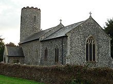 Colney St Andrew
Colney is a village in the western outskirts of Norwich in Norfolk, England. It is in the administrative district of South Norfolk. It covers an area of 3.83 km2 (1.48 sq mi) and had a population of 124 in 35 households at the 2001 census.[1]
Its church, St Andrew, is one of 124 existing round-tower churches in Norfolk.
Colney is home to the Norfolk and Norwich University Hospital, John Innes Centre and Institute of Food Research. It's also the location of Norwich City F.C.'s training ground.
The River Yare flows through it.
Notes
- ^ "Colney parish information". South Norfolk Council. 4 January 2006. http://www.south-norfolk.gov.uk/democracy/Colney_parish.asp. Retrieved 20 June 2009.
External links
 Media related to Colney at Wikimedia CommonsCategories:
- South Norfolk
- Villages in Norfolk
- Civil parishes in Norfolk
- United Kingdom church stubs
- Norfolk geography stubs


Wikimedia Foundation. 2010.